<< Our Photo Pages >> Maesbury Castle - Hillfort in England in Somerset
Submitted by vicky on Tuesday, 10 December 2002 Page Views: 12645
Iron Age and Later PrehistorySite Name: Maesbury CastleCountry: England
NOTE: This site is 0.604 km away from the location you searched for.
County: Somerset Type: Hillfort
Nearest Village: Oakhill
Map Ref: ST610472 Landranger Map Number: 183
Latitude: 51.222653N Longitude: 2.559841W
Condition:
| 5 | Perfect |
| 4 | Almost Perfect |
| 3 | Reasonable but with some damage |
| 2 | Ruined but still recognisable as an ancient site |
| 1 | Pretty much destroyed, possibly visible as crop marks |
| 0 | No data. |
| -1 | Completely destroyed |
| 5 | Superb |
| 4 | Good |
| 3 | Ordinary |
| 2 | Not Good |
| 1 | Awful |
| 0 | No data. |
| 5 | Can be driven to, probably with disabled access |
| 4 | Short walk on a footpath |
| 3 | Requiring a bit more of a walk |
| 2 | A long walk |
| 1 | In the middle of nowhere, a nightmare to find |
| 0 | No data. |
| 5 | co-ordinates taken by GPS or official recorded co-ordinates |
| 4 | co-ordinates scaled from a detailed map |
| 3 | co-ordinates scaled from a bad map |
| 2 | co-ordinates of the nearest village |
| 1 | co-ordinates of the nearest town |
| 0 | no data |
Internal Links:
External Links:
")
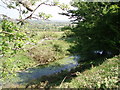
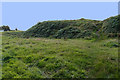
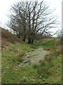
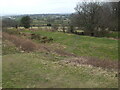
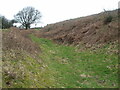
The view on a clear day is fantastic and offers almost a 360° degee panorama view of the Somerset Levels and the Mendips.
You may be viewing yesterday's version of this page. To see the most up to date information please register for a free account.
")
Do not use the above information on other web sites or publications without permission of the contributor.
coldrum has found this location on Google Street View:
Nearby Images from Geograph Britain and Ireland:
©2006(licence)
©2020(licence)
©2021(licence)
©2021(licence)
©2021(licence)
The above images may not be of the site on this page, they are loaded from Geograph.
Please Submit an Image of this site or go out and take one for us!
Click here to see more info for this site
Nearby sites
Key: Red: member's photo, Blue: 3rd party photo, Yellow: other image, Green: no photo - please go there and take one, Grey: site destroyed
Download sites to:
KML (Google Earth)
GPX (GPS waypoints)
CSV (Garmin/Navman)
CSV (Excel)
To unlock full downloads you need to sign up as a Contributory Member. Otherwise downloads are limited to 50 sites.
Turn off the page maps and other distractions
Nearby sites listing. In the following links * = Image available
2.2km SW 219° Crapnell Stone Circle (ST596455)
2.2km NNW 328° Whitnell Corner Barrows* Barrow Cemetery (ST5982849096)
2.7km ESE 112° Beacon Hill (Oakhill) Barrows* Barrow Cemetery (ST63484616)
3.9km NE 42° Blackers Hill Promontory Fort* Hillfort (ST6364850045)
4.3km NNE 31° Three Tuns Tumuli* Barrow Cemetery (ST6324250870)
4.5km WSW 249° King's Castle (Wells) Ancient Village or Settlement (ST568456)
4.7km E 83° Fairy Cave Cave or Rock Shelter (ST65654775)
4.9km WNW 287° Pen Hill Longbarrow* Long Barrow (ST563487)
5.3km SE 133° Doulting Quarries barrow* Modern Stone Circle etc (ST64824353)
5.4km SE 137° St Aldhelm's Well* Holy Well or Sacred Spring (ST647432)
5.7km WNW 297° Drove Cottage Henge* Henge (ST559498)
5.7km NE 42° Fry's Well* Holy Well or Sacred Spring (ST649514)
5.7km ENE 67° Stratton on the Fosse Artificial Mound (ST66314938)
5.9km WNW 299° Hunter's Lodge Inn Barrow* Round Barrow(s) (ST559501)
5.9km N 351° Lime House Long Barrow* Long Barrow (ST60095305)
5.9km WSW 256° St Andrew's Well (Wells)* Holy Well or Sacred Spring (ST5522745824)
6.0km WSW 257° Wells Cathedral* Early Christian Sculptured Stone (ST5514645865)
6.0km WSW 254° Glastonbury Tor milestone at Wells* Modern Stone Circle etc (ST552456)
6.0km WSW 257° Wells and Mendip Museum* Museum (ST551459)
6.1km NNW 347° Chewton Mendip Cross* Ancient Cross (ST5962353136)
6.2km N 351° Barrow House Farm Long Barrow * Chambered Tomb (ST60095334)
6.6km SE 132° West Cranmore Round Barrows* Barrow Cemetery (ST65844274)
7.2km N 9° Ston Easton Barrow* Round Barrow(s) (ST622543)
7.4km WNW 299° Fair Lady Well* Holy Well or Sacred Spring (ST54515079)
7.8km W 275° Badger Hole (Somerset) Cave or Rock Shelter (ST53244795)
View more nearby sites and additional images


 We would like to know more about this location. Please feel free to add a brief description and any relevant information in your own language.
 Wir möchten mehr über diese Stätte erfahren. Bitte zögern Sie nicht, eine kurze Beschreibung und relevante Informationen in Deutsch hinzuzufügen.
 Nous aimerions en savoir encore un peu sur les lieux. S'il vous plaît n'hesitez pas à ajouter une courte description et tous les renseignements pertinents dans votre propre langue.
 Quisieramos informarnos un poco más de las lugares. No dude en añadir una breve descripción y otros datos relevantes en su propio idioma.