<< Our Photo Pages >> Pulpit Rock (Portland) - Rock Outcrop in England in Dorset
Submitted by Bladup on Thursday, 14 March 2024 Page Views: 112
Natural PlacesSite Name: Pulpit Rock (Portland)Country: England
NOTE: This site is 0.502 km away from the location you searched for.
County: Dorset Type: Rock Outcrop
Nearest Town: Dorchester Nearest Village: Weymouth
Map Ref: SY675683
Latitude: 50.513581N Longitude: 2.459732W
Condition:
| 5 | Perfect |
| 4 | Almost Perfect |
| 3 | Reasonable but with some damage |
| 2 | Ruined but still recognisable as an ancient site |
| 1 | Pretty much destroyed, possibly visible as crop marks |
| 0 | No data. |
| -1 | Completely destroyed |
| 5 | Superb |
| 4 | Good |
| 3 | Ordinary |
| 2 | Not Good |
| 1 | Awful |
| 0 | No data. |
| 5 | Can be driven to, probably with disabled access |
| 4 | Short walk on a footpath |
| 3 | Requiring a bit more of a walk |
| 2 | A long walk |
| 1 | In the middle of nowhere, a nightmare to find |
| 0 | No data. |
| 5 | co-ordinates taken by GPS or official recorded co-ordinates |
| 4 | co-ordinates scaled from a detailed map |
| 3 | co-ordinates scaled from a bad map |
| 2 | co-ordinates of the nearest village |
| 1 | co-ordinates of the nearest town |
| 0 | no data |
Internal Links:
External Links:
 (PID:270272)")
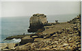
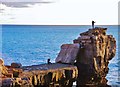
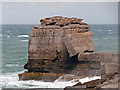
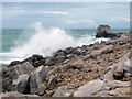
A rock outcrop near the Southern Tip of Portland Bill
You may be viewing yesterday's version of this page. To see the most up to date information please register for a free account.
Do not use the above information on other web sites or publications without permission of the contributor.
Nearby Images from Geograph Britain and Ireland:
©2006(licence)
©2011(licence)
©2012(licence)

©2012(licence)
©2012(licence)
The above images may not be of the site on this page, they are loaded from Geograph.
Please Submit an Image of this site or go out and take one for us!
Click here to see more info for this site
Nearby sites
Key: Red: member's photo, Blue: 3rd party photo, Yellow: other image, Green: no photo - please go there and take one, Grey: site destroyed
Download sites to:
KML (Google Earth)
GPX (GPS waypoints)
CSV (Garmin/Navman)
CSV (Excel)
To unlock full downloads you need to sign up as a Contributory Member. Otherwise downloads are limited to 50 sites.
Turn off the page maps and other distractions
Nearby sites listing. In the following links * = Image available
1.4km NE 45° Culverwell Mesolithic Site* Ancient Village or Settlement (SY685693)
4.3km NNE 12° Tout Quarry Sculpture Park - The Circle of Stones* Modern Stone Circle etc (SY68397248)
4.7km NNE 13° Tout Quarry Sculpture Park Alignment* Modern Stone Circle etc (SY68577283)
4.7km NNE 19° Kingbarrow Modern Stone Circle etc (SY6907772745)
4.7km NNE 15° Tout Quarry Sculpture Park Stone Circle* Modern Stone Circle etc (SY68747286)
4.8km N 9° Jacob's Well (Portland)* Holy Well or Sacred Spring (SY683730)
4.9km NE 35° Grove Road* Stone Circle (SY703723)
9.8km N 360° Dripping Well (Weymouth) Holy Well or Sacred Spring (SY6750478079)
15.6km N 7° Chalbury* Hillfort (SY695838)
16.0km NNE 27° Southdown (Dorset)* Barrow Cemetery (SY749825)
16.5km N 5° Bincombe Barrows* Barrow Cemetery (SY689847)
16.8km NNE 24° Poxwell Cairn* Cairn (SY74518357)
16.8km NE 40° Chaldon Down* Barrow Cemetery (SY783812)
16.8km N 11° Northdown (Dorset)* Barrow Cemetery (SY708848)
17.0km N 355° Upwey Wishing Well* Holy Well or Sacred Spring (SY661852)
17.2km N 9° Broadmayne Bank Barrow* Long Barrow (SY702853)
17.4km N 1° Bincombe Down* Barrow Cemetery (SY679857)
17.5km N 359° Ridgeway Hill* Barrow Cemetery (SY672858)
17.5km NNW 348° Friar Waddon Hill Barrow Cemetery (SY641855)
17.6km NE 42° Wardstone Barrow* Round Barrow(s) (SY79338133)
17.7km N 7° Whitcombe 1* Long Barrow (SY699858)
17.7km N 1° Winterborne Came 18b (Bincombe) Cairn (SY680860)
18.0km N 3° Came Down* Barrow Cemetery (SY687863)
18.3km N 356° Upwey Ridgeway* Barrow Cemetery (SY66298659)
18.4km NNW 342° Waddon Henge Henge (SY6185085783)
View more nearby sites and additional images


 We would like to know more about this location. Please feel free to add a brief description and any relevant information in your own language.
 Wir möchten mehr über diese Stätte erfahren. Bitte zögern Sie nicht, eine kurze Beschreibung und relevante Informationen in Deutsch hinzuzufügen.
 Nous aimerions en savoir encore un peu sur les lieux. S'il vous plaît n'hesitez pas à ajouter une courte description et tous les renseignements pertinents dans votre propre langue.
 Quisieramos informarnos un poco más de las lugares. No dude en añadir una breve descripción y otros datos relevantes en su propio idioma.