<< Our Photo Pages >> Tyra Stone - Rock Art in Czech Republic in Moravia
Submitted by ladrin on Monday, 19 August 2024 Page Views: 1660
Multi-periodSite Name: Tyra Stone Alternative Name: Celtic Stone, Keltský kámen, Sluneční kámenCountry: Czech Republic
NOTE: This site is 15.853 km away from the location you searched for.
Region: Moravia Type: Rock Art
Nearest Town: Třinec Nearest Village: Tyra
Latitude: 49.607874N Longitude: 18.631099E
Condition:
| 5 | Perfect |
| 4 | Almost Perfect |
| 3 | Reasonable but with some damage |
| 2 | Ruined but still recognisable as an ancient site |
| 1 | Pretty much destroyed, possibly visible as crop marks |
| 0 | No data. |
| -1 | Completely destroyed |
| 5 | Superb |
| 4 | Good |
| 3 | Ordinary |
| 2 | Not Good |
| 1 | Awful |
| 0 | No data. |
| 5 | Can be driven to, probably with disabled access |
| 4 | Short walk on a footpath |
| 3 | Requiring a bit more of a walk |
| 2 | A long walk |
| 1 | In the middle of nowhere, a nightmare to find |
| 0 | No data. |
| 5 | co-ordinates taken by GPS or official recorded co-ordinates |
| 4 | co-ordinates scaled from a detailed map |
| 3 | co-ordinates scaled from a bad map |
| 2 | co-ordinates of the nearest village |
| 1 | co-ordinates of the nearest town |
| 0 | no data |
Internal Links:
External Links:

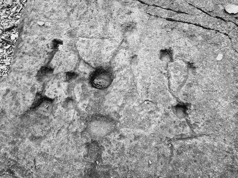
Some of them are square, some round shaped and some are pretty large. Most of the hollows are connected in some sort of pattern.
Recent discovery of an prehistoric bronze axe in this area can help with dating, probably to the Hallstatt/La Tène period. Pottery sherds found around are of medieval origin which corresponds to obviously later carvings of different types of crosses on a sides of boulder.
According to the alignment of the holes in spring/autumn equinox and also summer solstice axes, this prehistoric cultic object could serve as very precise calendar. But that's just a theory.
There are more stones in the close vicinity. Some seems to be creating enclosure to the main boulder. The location of this prehistoric site is easy as it is already in the maps but the way there can be quite a challenge. And since the stone is on private property, permission is needed.
You may be viewing yesterday's version of this page. To see the most up to date information please register for a free account.


Do not use the above information on other web sites or publications without permission of the contributor.
Click here to see more info for this site
Nearby sites
Click here to view sites on an interactive map of the areaKey: Red: member's photo, Blue: 3rd party photo, Yellow: other image, Green: no photo - please go there and take one, Grey: site destroyed
Download sites to:
KML (Google Earth)
GPX (GPS waypoints)
CSV (Garmin/Navman)
CSV (Excel)
To unlock full downloads you need to sign up as a Contributory Member. Otherwise downloads are limited to 50 sites.
Turn off the page maps and other distractions
Nearby sites listing. In the following links * = Image available
11.1km NNE 15° Puńców Settlement* Ancient Village or Settlement
11.6km NE 48° Góra Ostry Settlement* Ancient Village or Settlement
12.9km NE 38° Góra Tuł Settlement* Ancient Village or Settlement
14.4km NE 40° Góra Grodzisko Settlement* Ancient Village or Settlement
15.4km NE 36° Machulowa Settlement* Ancient Village or Settlement
16.0km N 359° Grodzisko Góra Zamkowa - Cieszyn* Hillfort
22.5km NNE 27° Grodzisko Międzyświeć* Hillfort
30.5km NE 51° Palenica Earthwork* Misc. Earthwork
30.8km NE 49° Grodzisko Zómczysko* Ancient Village or Settlement
30.8km NE 46° Młyńska Kępa Settlement* Ancient Village or Settlement
36.9km NE 49° Grodzisko Stare Bielsko* Hillfort
39.2km NW 318° Landek hill Ancient Village or Settlement
42.9km WSW 245° Vidče Stone Spheres* Natural Stone / Erratic / Other Natural Feature
46.3km NW 311° Dobroslavice* Ancient Cross
52.3km ENE 79° Grodzisko Gilowice* Hillfort
61.6km NNW 331° Muzeum w Raciborzu* Museum
68.6km ENE 66° Grodzisko Gorzeń Górny* Hillfort
71.4km ENE 75° Grodzisko Zembrzyce* Promontory Fort / Cliff Castle
71.5km ENE 77° Muzeum Miejskie Suchej Beskidzkiej* Museum
74.8km N 355° Kurhan Łany Wielkie* Round Barrow(s)
75.2km NNW 330° Grodzisko Dzielawy Hillfort
77.2km SE 138° Skalná päsť* Rock Outcrop
78.6km ENE 69° Grodzisko Bugaj* Hillfort
83.2km SE 132° Archeoskanzen Havránok* Museum
87.6km W 260° Predmosti* Ancient Village or Settlement
View more nearby sites and additional images


 We would like to know more about this location. Please feel free to add a brief description and any relevant information in your own language.
 Wir möchten mehr über diese Stätte erfahren. Bitte zögern Sie nicht, eine kurze Beschreibung und relevante Informationen in Deutsch hinzuzufügen.
 Nous aimerions en savoir encore un peu sur les lieux. S'il vous plaît n'hesitez pas à ajouter une courte description et tous les renseignements pertinents dans votre propre langue.
 Quisieramos informarnos un poco más de las lugares. No dude en añadir una breve descripción y otros datos relevantes en su propio idioma.