<< Other Photo Pages >> Anthropomorphic Stelae near Mount Kremenets - Carving in Ukraine
Submitted by Andy B on Monday, 16 May 2022 Page Views: 1693
Early Medieval (Dark Age)Site Name: Anthropomorphic Stelae near Mount Kremenets Alternative Name: Gora KremenetsCountry: Ukraine Type: Carving
Nearest Town: Slovjansk Nearest Village: Izyum
Latitude: 49.178909N Longitude: 37.276767E
Condition:
| 5 | Perfect |
| 4 | Almost Perfect |
| 3 | Reasonable but with some damage |
| 2 | Ruined but still recognisable as an ancient site |
| 1 | Pretty much destroyed, possibly visible as crop marks |
| 0 | No data. |
| -1 | Completely destroyed |
| 5 | Superb |
| 4 | Good |
| 3 | Ordinary |
| 2 | Not Good |
| 1 | Awful |
| 0 | No data. |
| 5 | Can be driven to, probably with disabled access |
| 4 | Short walk on a footpath |
| 3 | Requiring a bit more of a walk |
| 2 | A long walk |
| 1 | In the middle of nowhere, a nightmare to find |
| 0 | No data. |
| 5 | co-ordinates taken by GPS or official recorded co-ordinates |
| 4 | co-ordinates scaled from a detailed map |
| 3 | co-ordinates scaled from a bad map |
| 2 | co-ordinates of the nearest village |
| 1 | co-ordinates of the nearest town |
| 0 | no data |
Internal Links:
External Links:
")
Source: The Stoic Observer on Twitter
XIII added:
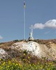
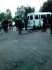
Gora Kremenets is the highest point in Kharkiv (177 meters). On the hill there is a collection of stone women (babas) collected from the Kharkiv region and a monument dedicated to the soldiers who died in the Second World War.
Source: discover.ua
Streetview:
You may be viewing yesterday's version of this page. To see the most up to date information please register for a free account.
")
")
Do not use the above information on other web sites or publications without permission of the contributor.
Nearby Images from Flickr

The above images may not be of the site on this page, but were taken nearby. They are loaded from Flickr so please click on them for image credits.
Click here to see more info for this site
Nearby sites
Click here to view sites on an interactive map of the areaKey: Red: member's photo, Blue: 3rd party photo, Yellow: other image, Green: no photo - please go there and take one, Grey: site destroyed
Download sites to:
KML (Google Earth)
GPX (GPS waypoints)
CSV (Garmin/Navman)
CSV (Excel)
To unlock full downloads you need to sign up as a Contributory Member. Otherwise downloads are limited to 50 sites.
Turn off the page maps and other distractions
Nearby sites listing. In the following links * = Image available
85.6km S 171° Popov Yar 2* Barrow Cemetery
117.8km NW 321° Kharkiv Historical Museum* Museum
145.0km NNW 349° Hillfort Krapivinskoe* Hillfort
149.2km SE 125° Merheleva Ridge Barrow Cemetery
180.9km WSW 244° Dmytro Yavornytsky National Historical Museum of Dnipro* Museum
189.6km WSW 242° Sursʹkyy Kromlekh* Round Barrow(s)
216.5km SW 226° Zaporizhzhya Regional Museum* Museum
220.3km SW 227° Dolmens Scythian Camp* Burial Chamber or Dolmen
232.9km S 175° Mariupol Museum of Local Lore* Museum
243.3km NNE 32° Mostischensky Stone Labyrinth* Ancient Palace
271.9km S 188° Stone Babas on Tsentralna Street* Carving
273.2km SW 235° Chertomlyk Kurgan Round Barrow(s)
278.9km NNW 343° Polovetskiy warrior* Sculptured Stone
281.9km SSW 209° Kamyana Mohyla Rock Cut Tomb
286.2km SW 235° Tolstaja Mogila Burial Mound Round Barrow(s)
287.3km SE 137° Kobyakovo Settlement* Ancient Village or Settlement
287.3km SE 137° Kobyakovo hillfort* Hillfort
290.9km WSW 253° Bohdaniv Kurgan Burial Mound Round Barrow(s)
293.4km WSW 247° Mohyla Baba* Round Barrow(s)
295.0km SW 230° Mamay-Hora* Round Barrow(s)
295.3km SSW 209° Melitopol Museum of Local History* Museum
299.5km SW 228° Znamenskoye Round Barrow(s)
305.1km NNE 17° Green Stone on the river Veduga* Natural Stone / Erratic / Other Natural Feature
326.4km SW 222° Kozel Burial Mound Round Barrow(s)
332.1km SW 221° Oguz Burial Mound Round Barrow(s)
View more nearby sites and additional images


 We would like to know more about this location. Please feel free to add a brief description and any relevant information in your own language.
 Wir möchten mehr über diese Stätte erfahren. Bitte zögern Sie nicht, eine kurze Beschreibung und relevante Informationen in Deutsch hinzuzufügen.
 Nous aimerions en savoir encore un peu sur les lieux. S'il vous plaît n'hesitez pas à ajouter une courte description et tous les renseignements pertinents dans votre propre langue.
 Quisieramos informarnos un poco más de las lugares. No dude en añadir una breve descripción y otros datos relevantes en su propio idioma.