<< Text Pages >> Dolmen du Champ-du-Saule 3 - Burial Chamber or Dolmen in France in Bourgogne:Côte-d'Or (21)
Submitted by holger_rix on Thursday, 04 February 2016 Page Views: 818
Neolithic and Bronze AgeSite Name: Dolmen du Champ-du-Saule 3Country: France
NOTE: This site is 12.082 km away from the location you searched for.
Département: Bourgogne:Côte-d'Or (21) Type: Burial Chamber or Dolmen
Nearest Town: Beaune Nearest Village: Marcilly-Ogny
Latitude: 47.243889N Longitude: 4.437500E
Condition:
| 5 | Perfect |
| 4 | Almost Perfect |
| 3 | Reasonable but with some damage |
| 2 | Ruined but still recognisable as an ancient site |
| 1 | Pretty much destroyed, possibly visible as crop marks |
| 0 | No data. |
| -1 | Completely destroyed |
| 5 | Superb |
| 4 | Good |
| 3 | Ordinary |
| 2 | Not Good |
| 1 | Awful |
| 0 | No data. |
| 5 | Can be driven to, probably with disabled access |
| 4 | Short walk on a footpath |
| 3 | Requiring a bit more of a walk |
| 2 | A long walk |
| 1 | In the middle of nowhere, a nightmare to find |
| 0 | No data. |
| 5 | co-ordinates taken by GPS or official recorded co-ordinates |
| 4 | co-ordinates scaled from a detailed map |
| 3 | co-ordinates scaled from a bad map |
| 2 | co-ordinates of the nearest village |
| 1 | co-ordinates of the nearest town |
| 0 | no data |
Be the first person to rate this site - see the 'Contribute!' box in the right hand menu.
Internal Links:
External Links:
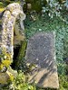
Burial Chamber (Dolmen) in Bourgogne:Côte-d'Or (21)
Remains of three slab sided chambers within their tumulus, are to be found near to the village of Marcilly-Ogny, Côte-d'Or.
You may be viewing yesterday's version of this page. To see the most up to date information please register for a free account.
Do not use the above information on other web sites or publications without permission of the contributor.
Nearby Images from Flickr
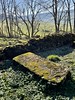
The above images may not be of the site on this page, but were taken nearby. They are loaded from Flickr so please click on them for image credits.
Click here to see more info for this site
Nearby sites
Click here to view sites on an interactive map of the areaKey: Red: member's photo, Blue: 3rd party photo, Yellow: other image, Green: no photo - please go there and take one, Grey: site destroyed
Download sites to:
KML (Google Earth)
GPX (GPS waypoints)
CSV (Garmin/Navman)
CSV (Excel)
To unlock full downloads you need to sign up as a Contributory Member. Otherwise downloads are limited to 50 sites.
Turn off the page maps and other distractions
Nearby sites listing. In the following links * = Image available
143m W 269° Dolmen du Champ-du-Saule 2 Burial Chamber or Dolmen
193m SW 228° Dolmen du Champ-du-Saule 1 Burial Chamber or Dolmen
8.0km W 259° Pierre-Pointe* Standing Stone (Menhir)
17.0km NNE 20° Camp de Myard* Ancient Village or Settlement
23.5km NNW 328° Cimetière Menhir* Standing Stone (Menhir)
24.3km WNW 303° Poron Meurger* Rock Art
24.5km NW 312° Roche d'Arthur* Standing Stone (Menhir)
24.5km NW 312° Pierre Pelot* Standing Stone (Menhir)
27.1km ESE 101° Dolmen du Poiset Burial Chamber or Dolmen
28.6km W 277° Chevresse Dolmen* Burial Chamber or Dolmen
29.3km W 278° Dolmen de la Pierre-Plate* Burial Chamber or Dolmen
29.6km E 99° Dolmen du Bois-de-Monfarbeau 2* Burial Chamber or Dolmen
29.7km E 99° Dolmen du Bois-de-Monfarbeau 1* Burial Chamber or Dolmen
29.8km SSW 198° Camp de la Justice Alignements* Stone Row / Alignment
31.3km W 265° Table du Festin des Fées Rock Art
32.0km SE 130° Croconnet Tumulus Chambered Cairn
32.3km ESE 105° Collonges Ciste Burial Chamber or Dolmen
32.6km SE 136° Tombeaux du Single Burial Chamber or Dolmen
32.7km ENE 76° Sur-les-Roches Burial Chamber or Dolmen
33.6km NE 51° Ciste du Val-Courbe Burial Chamber or Dolmen
33.8km SSW 200° Temple of Janus (Autun)* Ancient Temple
35.1km SE 136° Dolmen dit la Pierre-Brûlée* Burial Chamber or Dolmen
35.2km NNW 340° Menhir-Sainte-Christine* Standing Stone (Menhir)
35.9km WNW 290° Roche aux Fées (Quarré-les-Tombes)* Rock Outcrop
36.4km E 84° Ciste du Mont-Afrique Burial Chamber or Dolmen
View more nearby sites and additional images


 We would like to know more about this location. Please feel free to add a brief description and any relevant information in your own language.
 Wir möchten mehr über diese Stätte erfahren. Bitte zögern Sie nicht, eine kurze Beschreibung und relevante Informationen in Deutsch hinzuzufügen.
 Nous aimerions en savoir encore un peu sur les lieux. S'il vous plaît n'hesitez pas à ajouter une courte description et tous les renseignements pertinents dans votre propre langue.
 Quisieramos informarnos un poco más de las lugares. No dude en añadir una breve descripción y otros datos relevantes en su propio idioma.