<< Text Pages >> Menhir de Charmeau - Standing Stone (Menhir) in France in Bourgogne:Saône-et-Loire (71)
Submitted by AlexHunger on Tuesday, 13 July 2010 Page Views: 3823
Neolithic and Bronze AgeSite Name: Menhir de Charmeau Alternative Name: Menhir de BroyeCountry: France
NOTE: This site is 4.907 km away from the location you searched for.
Département: Bourgogne:Saône-et-Loire (71) Type: Standing Stone (Menhir)
Nearest Town: Autun Nearest Village: Charmeau
Latitude: 46.868713N Longitude: 4.306505E
Condition:
| 5 | Perfect |
| 4 | Almost Perfect |
| 3 | Reasonable but with some damage |
| 2 | Ruined but still recognisable as an ancient site |
| 1 | Pretty much destroyed, possibly visible as crop marks |
| 0 | No data. |
| -1 | Completely destroyed |
| 5 | Superb |
| 4 | Good |
| 3 | Ordinary |
| 2 | Not Good |
| 1 | Awful |
| 0 | No data. |
| 5 | Can be driven to, probably with disabled access |
| 4 | Short walk on a footpath |
| 3 | Requiring a bit more of a walk |
| 2 | A long walk |
| 1 | In the middle of nowhere, a nightmare to find |
| 0 | No data. |
| 5 | co-ordinates taken by GPS or official recorded co-ordinates |
| 4 | co-ordinates scaled from a detailed map |
| 3 | co-ordinates scaled from a bad map |
| 2 | co-ordinates of the nearest village |
| 1 | co-ordinates of the nearest town |
| 0 | no data |
Internal Links:
External Links:
Standing Stone (Menhir) in Bourgogne:Saône-et-Loire (71)
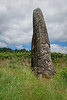
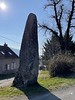
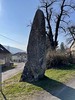
Large, 4,65 meter tall, pointy Menhir in the center of the village.
Info with Picture:
www.mairie-broye.fr
You may be viewing yesterday's version of this page. To see the most up to date information please register for a free account.
Do not use the above information on other web sites or publications without permission of the contributor.
Nearby Images from Flickr
The above images may not be of the site on this page, but were taken nearby. They are loaded from Flickr so please click on them for image credits.
Click here to see more info for this site
Nearby sites
Click here to view sites on an interactive map of the areaKey: Red: member's photo, Blue: 3rd party photo, Yellow: other image, Green: no photo - please go there and take one, Grey: site destroyed
Download sites to:
KML (Google Earth)
GPX (GPS waypoints)
CSV (Garmin/Navman)
CSV (Excel)
To unlock full downloads you need to sign up as a Contributory Member. Otherwise downloads are limited to 50 sites.
Turn off the page maps and other distractions
Nearby sites listing. In the following links * = Image available
9.5km NW 322° Pierre de la Grande Corvée Standing Stone (Menhir)
10.0km N 352° Temple of Janus (Autun)* Ancient Temple
12.2km WSW 244° Menhir du Chafaud Standing Stone (Menhir)
12.3km ESE 106° Menhir des Caillots Standing Stone (Menhir)
13.3km ENE 67° Pierre Guénachère* Sculptured Stone
13.4km N 3° Camp de la Justice Alignements* Stone Row / Alignment
17.3km E 87° Menhirs d'Epoigny* Standing Stones
21.5km WNW 287° Oppidum de Bibracte* Hillfort
26.7km SE 137° Pierre-aux-Fées (St-Micaud)* Standing Stone (Menhir)
27.9km ENE 78° Mont-de-Sene 2 Burial Chamber or Dolmen
27.9km ENE 77° Cul Blanc Dolmens* Burial Chamber or Dolmen
28.0km ENE 78° Mont-de-Sène dolmen 1 Burial Chamber or Dolmen
28.1km ENE 78° Mont-de-Sene 3 Burial Chamber or Dolmen
28.2km ENE 79° Mont-de-Sene 5 Burial Chamber or Dolmen
28.2km ENE 78° Mont-de-Sene 4 Burial Chamber or Dolmen
28.5km ENE 71° La Garenne (La Rochepot) Burial Chamber or Dolmen
29.1km ENE 74° Allée Couverte de la Chaume Passage Grave
29.6km ENE 72° La Pierre qui Vire (Rochepot)* Burial Chamber or Dolmen
29.7km ENE 71° Chateillon Passage Grave
30.9km WSW 245° Chigy Menhir* Standing Stone (Menhir)
31.2km W 276° Menhir dit la Pierre Aiguë (Villapourçon) Standing Stone (Menhir)
35.1km SE 144° Menhir de Saint-Clément 2 Standing Stone (Menhir)
35.2km SE 144° Menhir de Saint-Clément 1 Standing Stone (Menhir)
37.3km ENE 61° Tombeaux du Single Burial Chamber or Dolmen
37.7km NW 318° Pierres à Sacrifices de Faubouloin Rock Outcrop
View more nearby sites and additional images


 We would like to know more about this location. Please feel free to add a brief description and any relevant information in your own language.
 Wir möchten mehr über diese Stätte erfahren. Bitte zögern Sie nicht, eine kurze Beschreibung und relevante Informationen in Deutsch hinzuzufügen.
 Nous aimerions en savoir encore un peu sur les lieux. S'il vous plaît n'hesitez pas à ajouter une courte description et tous les renseignements pertinents dans votre propre langue.
 Quisieramos informarnos un poco más de las lugares. No dude en añadir una breve descripción y otros datos relevantes en su propio idioma.