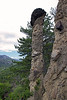
<< Other Photo Pages >> Demoiselles Coiffées de Théus - Rock Outcrop in France in Provence:Hautes-Alpes (05)
Submitted by holger_rix on Sunday, 01 May 2016 Page Views: 1893
Natural PlacesSite Name: Demoiselles Coiffées de Théus Alternative Name: Cheminée de Fées, HoodooCountry: France
NOTE: This site is 5.351 km away from the location you searched for.
Département: Provence:Hautes-Alpes (05) Type: Rock Outcrop
Nearest Town: Gap Nearest Village: Théus
Latitude: 44.477718N Longitude: 6.192903E
Condition:
| 5 | Perfect |
| 4 | Almost Perfect |
| 3 | Reasonable but with some damage |
| 2 | Ruined but still recognisable as an ancient site |
| 1 | Pretty much destroyed, possibly visible as crop marks |
| 0 | No data. |
| -1 | Completely destroyed |
| 5 | Superb |
| 4 | Good |
| 3 | Ordinary |
| 2 | Not Good |
| 1 | Awful |
| 0 | No data. |
| 5 | Can be driven to, probably with disabled access |
| 4 | Short walk on a footpath |
| 3 | Requiring a bit more of a walk |
| 2 | A long walk |
| 1 | In the middle of nowhere, a nightmare to find |
| 0 | No data. |
| 5 | co-ordinates taken by GPS or official recorded co-ordinates |
| 4 | co-ordinates scaled from a detailed map |
| 3 | co-ordinates scaled from a bad map |
| 2 | co-ordinates of the nearest village |
| 1 | co-ordinates of the nearest town |
| 0 | no data |
Be the first person to rate this site - see the 'Contribute!' box in the right hand menu.
Internal Links:
External Links:
")
Théus, Gap, Hautes-Alpes, Provence-Alpes-Côte d'Azur
You may be viewing yesterday's version of this page. To see the most up to date information please register for a free account.
")
")
Do not use the above information on other web sites or publications without permission of the contributor.
Nearby Images from Flickr
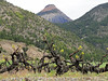
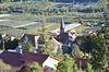
The above images may not be of the site on this page, but were taken nearby. They are loaded from Flickr so please click on them for image credits.
Click here to see more info for this site
Nearby sites
Click here to view sites on an interactive map of the areaKey: Red: member's photo, Blue: 3rd party photo, Yellow: other image, Green: no photo - please go there and take one, Grey: site destroyed
Download sites to:
KML (Google Earth)
GPX (GPS waypoints)
CSV (Garmin/Navman)
CSV (Excel)
To unlock full downloads you need to sign up as a Contributory Member. Otherwise downloads are limited to 50 sites.
Turn off the page maps and other distractions
Nearby sites listing. In the following links * = Image available
10.3km N 9° Dolmen de Saint-Pancrace Burial Chamber or Dolmen
10.8km N 3° Tumulus de Saint-Pancrace Artificial Mound
11.9km W 267° Serres des Fourches Dolmen Burial Chamber or Dolmen
12.8km ENE 77° Demoiselles Coiffées de Pontis* Rock Outcrop
12.9km NW 315° Dolmen de Camargues Burial Chamber or Dolmen
14.0km E 90° Dolmen du Villard* Burial Chamber or Dolmen
19.4km ESE 120° Cairn du Vallon Chambered Cairn
19.4km ESE 118° Cairn du Gué Chambered Cairn
22.0km WSW 243° Tumulus de la Queylane Artificial Mound
22.8km N 2° Dolmen de Roranches Burial Chamber or Dolmen
23.7km NNW 333° Dolmen de Notre-Dame de Bois Vert Burial Chamber or Dolmen
25.5km WSW 243° La Condamine Tumulus Artificial Mound
30.3km ENE 59° Dolmen de Chateauroux Burial Chamber or Dolmen
32.6km WSW 242° Ferme de Chateau Bon Tumulus Artificial Mound
37.9km WSW 249° Bois de la Blache du Raoux Tumulus Artificial Mound
40.5km W 267° Grotte du Grapelet Cave or Rock Shelter
40.6km NE 46° Grotte de Rame Cave or Rock Shelter
43.2km NE 45° Roche de Rame Sepulture Cave or Rock Shelter
43.3km NE 45° La Roche-de-Rame Sepulture Ancient Village or Settlement
47.7km SW 232° Grotte des Trucs de la Chapelle Cave or Rock Shelter
51.7km W 267° Col des Tourettes Cave or Rock Shelter
52.2km W 267° Grotte des Aiguilles Cave or Rock Shelter
59.8km ENE 57° Menhir dit la Pierre Fiche (Ville-Vieille) Standing Stone (Menhir)
60.4km NE 34° Pierre à cupules dite la Pierre aux Oeufs Rock Art
63.3km S 173° Abri de l'Estodeou Cave or Rock Shelter
View more nearby sites and additional images


 We would like to know more about this location. Please feel free to add a brief description and any relevant information in your own language.
 Wir möchten mehr über diese Stätte erfahren. Bitte zögern Sie nicht, eine kurze Beschreibung und relevante Informationen in Deutsch hinzuzufügen.
 Nous aimerions en savoir encore un peu sur les lieux. S'il vous plaît n'hesitez pas à ajouter une courte description et tous les renseignements pertinents dans votre propre langue.
 Quisieramos informarnos un poco más de las lugares. No dude en añadir una breve descripción y otros datos relevantes en su propio idioma.