<< Our Photo Pages >> Pawtuckaway Balancing Rock - Natural Stone / Erratic / Other Natural Feature in United States in New England
Submitted by AlexAssa on Tuesday, 21 May 2019 Page Views: 6461
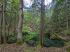
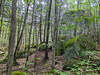
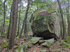
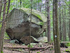
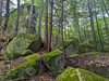
Natural PlacesSite Name: Pawtuckaway Balancing Rock Alternative Name: Pawtuckaway Boulder FieldCountry: United States Region: New England Type: Natural Stone / Erratic / Other Natural Feature
Nearest Town: Deerfield
Latitude: 43.118655N Longitude: 71.183088W
Condition:
| 5 | Perfect |
| 4 | Almost Perfect |
| 3 | Reasonable but with some damage |
| 2 | Ruined but still recognisable as an ancient site |
| 1 | Pretty much destroyed, possibly visible as crop marks |
| 0 | No data. |
| -1 | Completely destroyed |
| 5 | Superb |
| 4 | Good |
| 3 | Ordinary |
| 2 | Not Good |
| 1 | Awful |
| 0 | No data. |
| 5 | Can be driven to, probably with disabled access |
| 4 | Short walk on a footpath |
| 3 | Requiring a bit more of a walk |
| 2 | A long walk |
| 1 | In the middle of nowhere, a nightmare to find |
| 0 | No data. |
| 5 | co-ordinates taken by GPS or official recorded co-ordinates |
| 4 | co-ordinates scaled from a detailed map |
| 3 | co-ordinates scaled from a bad map |
| 2 | co-ordinates of the nearest village |
| 1 | co-ordinates of the nearest town |
| 0 | no data |
Internal Links:
External Links:
I have visited· I would like to visit
grenciae would like to visit
")
Pawtuckaway Boulder Field in State Park
You may be viewing yesterday's version of this page. To see the most up to date information please register for a free account.
")
")
")
Do not use the above information on other web sites or publications without permission of the contributor.
Nearby Images from Flickr

The above images may not be of the site on this page, but were taken nearby. They are loaded from Flickr so please click on them for image credits.
Click here to see more info for this site
Nearby sites
Click here to view sites on an interactive map of the areaKey: Red: member's photo, Blue: 3rd party photo, Yellow: other image, Green: no photo - please go there and take one, Grey: site destroyed
Download sites to:
KML (Google Earth)
GPX (GPS waypoints)
CSV (Garmin/Navman)
CSV (Excel)
To unlock full downloads you need to sign up as a Contributory Member. Otherwise downloads are limited to 50 sites.
Turn off the page maps and other distractions
Nearby sites listing. In the following links * = Image available
30.7km S 184° America's Stonehenge* Ancient Village or Settlement
55.6km WNW 291° Mount Kearsarge Indian Museum Museum
89.7km SW 221° Wachusett Stone* Natural Stone / Erratic / Other Natural Feature
100.3km S 175° Mary Caroline Herter Public Garden Modern Stone Circle etc
102.1km W 271° Bellows Falls Petroglyphs* Rock Art
111.4km NW 306° Humming Stone Norwich (Summstein) Modern Stone Circle etc
115.0km WSW 256° Brattleboro Petroglyphs Rock Art
117.6km WSW 254° Humming Stone Guilford (Summstein) Modern Stone Circle etc
117.9km S 184° Foxborough Prayer Seat (2)* Cairn
117.9km S 184° Foxborough Stone Pile* Cairn
118.0km S 184° Foxborough Prayer Seat (3)* Cairn
118.0km S 184° Foxborough Prayer Seat (11)* Cairn
118.1km S 184° Foxborough Perched Boulder (1)* Natural Stone / Erratic / Other Natural Feature
118.1km S 184° Foxborough Prayer Seat (4)* Cairn
118.2km S 184° Foxborough Prayer Seat (9)* Cairn
118.2km S 184° Foxborough Prayer Seat (1)* Cairn
118.2km S 184° Foxborough Marker Stone* Rock Outcrop
118.5km S 184° Foxborough Stone Row (2)* Stone Row / Alignment
118.6km S 184° Foxborough Standing Stone (1)* Standing Stone (Menhir)
118.6km S 184° Foxborough Prayer Seat and Stone Ring* Cairn
118.7km S 184° Foxborough Dolmen* Marker Stone
118.7km S 184° Foxborough Stone Row (1)* Stone Row / Alignment
118.7km S 184° Foxborough Standing Stone (2)* Marker Stone
118.8km S 184° Foxborough Perched Boulder (5)* Natural Stone / Erratic / Other Natural Feature
118.8km S 184° Foxborough Prayer Seat (6)* Cairn
View more nearby sites and additional images


 We would like to know more about this location. Please feel free to add a brief description and any relevant information in your own language.
 Wir möchten mehr über diese Stätte erfahren. Bitte zögern Sie nicht, eine kurze Beschreibung und relevante Informationen in Deutsch hinzuzufügen.
 Nous aimerions en savoir encore un peu sur les lieux. S'il vous plaît n'hesitez pas à ajouter une courte description et tous les renseignements pertinents dans votre propre langue.
 Quisieramos informarnos un poco más de las lugares. No dude en añadir una breve descripción y otros datos relevantes en su propio idioma.