<< Text Pages >> Chiatura - Ancient Temple in Georgia
Submitted by davidmorgan on Sunday, 27 February 2011 Page Views: 7587
Multi-periodSite Name: ChiaturaCountry: Georgia
NOTE: This site is 24.82 km away from the location you searched for.
Type: Ancient Temple
Nearest Town: Chiatura
Latitude: 42.287632N Longitude: 43.215708E
Condition:
| 5 | Perfect |
| 4 | Almost Perfect |
| 3 | Reasonable but with some damage |
| 2 | Ruined but still recognisable as an ancient site |
| 1 | Pretty much destroyed, possibly visible as crop marks |
| 0 | No data. |
| -1 | Completely destroyed |
| 5 | Superb |
| 4 | Good |
| 3 | Ordinary |
| 2 | Not Good |
| 1 | Awful |
| 0 | No data. |
| 5 | Can be driven to, probably with disabled access |
| 4 | Short walk on a footpath |
| 3 | Requiring a bit more of a walk |
| 2 | A long walk |
| 1 | In the middle of nowhere, a nightmare to find |
| 0 | No data. |
| 5 | co-ordinates taken by GPS or official recorded co-ordinates |
| 4 | co-ordinates scaled from a detailed map |
| 3 | co-ordinates scaled from a bad map |
| 2 | co-ordinates of the nearest village |
| 1 | co-ordinates of the nearest town |
| 0 | no data |
Be the first person to rate this site - see the 'Contribute!' box in the right hand menu.
Internal Links:
External Links:
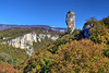
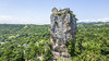
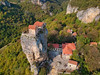
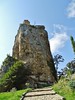
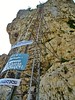
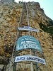
Ancient Temple in Georgia.
The site of a former pagan temple, now a church, on top of a sheer pillar of rock.
You may be viewing yesterday's version of this page. To see the most up to date information please register for a free account.
Do not use the above information on other web sites or publications without permission of the contributor.
Nearby Images from Flickr
The above images may not be of the site on this page, but were taken nearby. They are loaded from Flickr so please click on them for image credits.
Click here to see more info for this site
Nearby sites
Click here to view sites on an interactive map of the areaKey: Red: member's photo, Blue: 3rd party photo, Yellow: other image, Green: no photo - please go there and take one, Grey: site destroyed
Download sites to:
KML (Google Earth)
GPX (GPS waypoints)
CSV (Garmin/Navman)
CSV (Excel)
To unlock full downloads you need to sign up as a Contributory Member. Otherwise downloads are limited to 50 sites.
Turn off the page maps and other distractions
Nearby sites listing. In the following links * = Image available
97.9km SE 132° Tejisi Menhir* Standing Stone (Menhir)
103.4km SSE 147° Chikiani Menhir Standing Stone (Menhir)
105.2km SSE 168° Kat Kar Menhir Standing Stone (Menhir)
108.9km SSE 159° Abuli Fortress* Ancient Village or Settlement
109.2km N 357° City of the dead on River Chegem* Ancient Village or Settlement
122.0km SE 136° Mamulos Pantiani* Ancient Village or Settlement
126.2km WSW 250° Pichvnari* Ancient Village or Settlement
142.2km N 349° Ancient settlements on Kabardian Ridge Ancient Village or Settlement
142.9km N 8° Dolmen river Chegem* Burial Chamber or Dolmen
147.5km NNW 346° Bronze Age Settlements west of Nalchik Ancient Village or Settlement
166.2km SE 126° Gadachrili Gora* Ancient Village or Settlement
175.3km ENE 61° Dattykh hillfort* Hillfort
176.1km SSE 152° Gogaran Iron Age mausoleum Burial Chamber or Dolmen
180.7km WNW 300° Azantskiy Dolmen* Burial Chamber or Dolmen
190.3km SSE 162° Vardakar settlement Ancient Village or Settlement
195.0km SSE 154° Gegharot* Ancient Village or Settlement
196.2km WNW 295° Museum of Abkhazia Museum
196.2km WNW 295° Sukhumi Museum Dolmen* Burial Chamber or Dolmen
207.9km WNW 296° Dolmen Upper Eshera 1* Burial Chamber or Dolmen
208.3km S 173° Alem Rock Art* Rock Art
215.9km SE 135° Anapat Cave Rock Art
226.4km SSE 162° Kakavadzor temple Ancient Temple
226.4km SE 124° Yastytepe Ancient Village or Settlement
230.9km WNW 303° Dolmen Pskhu* Burial Chamber or Dolmen
231.6km WNW 303° Dolmen Pskhu 3* Burial Chamber or Dolmen
View more nearby sites and additional images


 We would like to know more about this location. Please feel free to add a brief description and any relevant information in your own language.
 Wir möchten mehr über diese Stätte erfahren. Bitte zögern Sie nicht, eine kurze Beschreibung und relevante Informationen in Deutsch hinzuzufügen.
 Nous aimerions en savoir encore un peu sur les lieux. S'il vous plaît n'hesitez pas à ajouter une courte description et tous les renseignements pertinents dans votre propre langue.
 Quisieramos informarnos un poco más de las lugares. No dude en añadir una breve descripción y otros datos relevantes en su propio idioma.