<< Other Photo Pages >> Kizil Caves of 1000 Buddhas - Cave or Rock Shelter in China
Submitted by KaiHofmann on Thursday, 11 August 2011 Page Views: 6013
Natural PlacesSite Name: Kizil Caves of 1000 BuddhasCountry: China
NOTE: This site is 27.365 km away from the location you searched for.
Type: Cave or Rock Shelter
Nearest Town: Aksu Nearest Village: Kizil
Latitude: 41.781412N Longitude: 82.503548E
Condition:
| 5 | Perfect |
| 4 | Almost Perfect |
| 3 | Reasonable but with some damage |
| 2 | Ruined but still recognisable as an ancient site |
| 1 | Pretty much destroyed, possibly visible as crop marks |
| 0 | No data. |
| -1 | Completely destroyed |
| 5 | Superb |
| 4 | Good |
| 3 | Ordinary |
| 2 | Not Good |
| 1 | Awful |
| 0 | No data. |
| 5 | Can be driven to, probably with disabled access |
| 4 | Short walk on a footpath |
| 3 | Requiring a bit more of a walk |
| 2 | A long walk |
| 1 | In the middle of nowhere, a nightmare to find |
| 0 | No data. |
| 5 | co-ordinates taken by GPS or official recorded co-ordinates |
| 4 | co-ordinates scaled from a detailed map |
| 3 | co-ordinates scaled from a bad map |
| 2 | co-ordinates of the nearest village |
| 1 | co-ordinates of the nearest town |
| 0 | no data |
Be the first person to rate this site - see the 'Contribute!' box in the right hand menu.
Internal Links:
External Links:
")
Caves with ancient Buddhistic paintings dated for 3rd-8th century CE.
You may be viewing yesterday's version of this page. To see the most up to date information please register for a free account.
")
Do not use the above information on other web sites or publications without permission of the contributor.
Nearby Images from Flickr
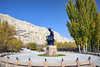
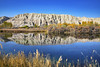
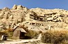
The above images may not be of the site on this page, but were taken nearby. They are loaded from Flickr so please click on them for image credits.
Click here to see more info for this site
Nearby sites
Click here to view sites on an interactive map of the areaKey: Red: member's photo, Blue: 3rd party photo, Yellow: other image, Green: no photo - please go there and take one, Grey: site destroyed
Download sites to:
KML (Google Earth)
GPX (GPS waypoints)
CSV (Garmin/Navman)
CSV (Excel)
To unlock full downloads you need to sign up as a Contributory Member. Otherwise downloads are limited to 50 sites.
Turn off the page maps and other distractions
Nearby sites listing. In the following links * = Image available
347.5km WNW 285° Karakol Park* Sculptured Stone
348.0km WNW 284° Karakol Regional Museum* Museum
354.0km ESE 102° Tarim River Tombs Barrow Cemetery
365.2km S 189° Karadong* Ancient Village or Settlement
423.4km NW 306° Complex Besshatyr* Artificial Mound
455.9km E 97° Buyantu-Bulaq Rock Art* Rock Art
457.6km SSE 165° Endere (China)* Ancient Village or Settlement
470.5km ENE 61° Sahensai Cemetery* Barrow Cemetery
472.3km ENE 60° Zinjiang Autonomous Region Museum* Museum
483.0km WNW 291° The Central State Museum of the Republic of Kazakhstan* Museum
520.5km S 176° Niya (China)* Ancient Village or Settlement
526.1km SSW 195° Rawak* Ancient Village or Settlement
533.0km ESE 106° Xiaohe Necropolis* Barrow Cemetery
540.6km ESE 105° Small River Cemetery* Barrow Cemetery
562.6km SSW 203° Dandan Oilik* Ancient Village or Settlement
563.4km ENE 74° Jiayi Cemetery* Barrow Cemetery
579.2km WSW 248° Mor Stupas* Ancient Temple
580.6km WNW 289° Targan Barrow Cemetery Barrow Cemetery
589.3km W 273° East Song Köl Balbal* Sculptured Stone
590.0km ENE 76° Astana Graves Rock Cut Tomb
590.0km ENE 76° Gaochang Ancient Village or Settlement
603.2km ESE 116° Miran (China)* Ancient Village or Settlement
606.3km WNW 283° Balasagun stone Balbas Sculptured Stone
611.2km WNW 294° Tamgaly Petroglyphs* Rock Art
618.5km N 357° Eleke Sazy Burial Mounds* Barrow Cemetery
View more nearby sites and additional images


 We would like to know more about this location. Please feel free to add a brief description and any relevant information in your own language.
 Wir möchten mehr über diese Stätte erfahren. Bitte zögern Sie nicht, eine kurze Beschreibung und relevante Informationen in Deutsch hinzuzufügen.
 Nous aimerions en savoir encore un peu sur les lieux. S'il vous plaît n'hesitez pas à ajouter une courte description et tous les renseignements pertinents dans votre propre langue.
 Quisieramos informarnos un poco más de las lugares. No dude en añadir una breve descripción y otros datos relevantes en su propio idioma.