<< Text Pages >> Tsarevi Kuli - Ancient Village or Settlement in North Macedonia
Submitted by coldrum on Thursday, 08 July 2010 Page Views: 5632
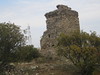
DigsSite Name: Tsarevi Kuli Alternative Name: Carevi KuliCountry: North Macedonia
NOTE: This site is 25.475 km away from the location you searched for.
Type: Ancient Village or Settlement
Nearest Town: Strumica Nearest Village: Strumica
Latitude: 41.432260N Longitude: 22.629260E
Condition:
| 5 | Perfect |
| 4 | Almost Perfect |
| 3 | Reasonable but with some damage |
| 2 | Ruined but still recognisable as an ancient site |
| 1 | Pretty much destroyed, possibly visible as crop marks |
| 0 | No data. |
| -1 | Completely destroyed |
| 5 | Superb |
| 4 | Good |
| 3 | Ordinary |
| 2 | Not Good |
| 1 | Awful |
| 0 | No data. |
| 5 | Can be driven to, probably with disabled access |
| 4 | Short walk on a footpath |
| 3 | Requiring a bit more of a walk |
| 2 | A long walk |
| 1 | In the middle of nowhere, a nightmare to find |
| 0 | No data. |
| 5 | co-ordinates taken by GPS or official recorded co-ordinates |
| 4 | co-ordinates scaled from a detailed map |
| 3 | co-ordinates scaled from a bad map |
| 2 | co-ordinates of the nearest village |
| 1 | co-ordinates of the nearest town |
| 0 | no data |
Be the first person to rate this site - see the 'Contribute!' box in the right hand menu.
Internal Links:
External Links:
Ancient Settlement in Macedonia (FYROM). Dating from the Chalcolithic/Early Bronze Age, this site has evidence of settlement right through to the Middle Ages.
There have been some interesting recent finds from the Middle Bronze Age and 4th century BCE.
The archaeological excavations at the Carevi Kuli (Tsar's Towers) site in 2009 were performed at several positions in order to finalize the excavations of the cultural layers in the south-eastern and central plateau, a part of the north-western plateau and the necropolis in the Southern hill sector (Juzen rid).
Note: Archaeologists Discover Vessels from Bronze Age and 4th Century in Eastern Macedonia
You may be viewing yesterday's version of this page. To see the most up to date information please register for a free account.
Do not use the above information on other web sites or publications without permission of the contributor.
Nearby Images from Flickr

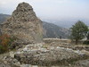
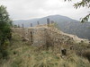
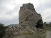
The above images may not be of the site on this page, but were taken nearby. They are loaded from Flickr so please click on them for image credits.
Click here to see more info for this site
Nearby sites
Click here to view sites on an interactive map of the areaKey: Red: member's photo, Blue: 3rd party photo, Yellow: other image, Green: no photo - please go there and take one, Grey: site destroyed
Download sites to:
KML (Google Earth)
GPX (GPS waypoints)
CSV (Garmin/Navman)
CSV (Excel)
To unlock full downloads you need to sign up as a Contributory Member. Otherwise downloads are limited to 50 sites.
Turn off the page maps and other distractions
Nearby sites listing. In the following links * = Image available
56.0km WNW 284° Stobi* Ancient Village or Settlement
70.7km NNE 14° Piyanets Museum Museum
73.1km S 191° Giannitsa Archontikon* Ancient Village or Settlement
75.3km NW 308° Bylazora Ancient Village or Settlement
75.8km S 187° Pella (Greece)* Ancient Village or Settlement
85.4km SW 214° Edessa* Ancient Village or Settlement
86.5km W 262° The Great Goddess with three faces* Natural Stone / Erratic / Other Natural Feature
90.5km WSW 254° Pavla chuka Burial Chamber or Dolmen
95.7km ENE 59° Megalith near Eleshnitza, Razlog region* Burial Chamber or Dolmen
95.7km SSW 206° Fleurons Macedonian Tomb* Chambered Tomb
95.9km SSW 206° Krisis Macedonian Tomb* Chambered Tomb
96.3km SSW 206° Kinch's Macedonian Tomb* Chambered Tomb
96.4km SSW 206° Lyson and Kallicleus Macedonian Tomb* Chambered Tomb
98.0km SSE 164° Karabournaki* Ancient Village or Settlement
99.5km SSW 207° Mieza* Ancient Village or Settlement
99.7km SSW 207° School of Aristotle* NOT SET
102.6km NW 309° The Sacred Stone of Tekia Standing Stone (Menhir)
108.1km NNW 329° Cocev Kamen* Cave or Rock Shelter
108.2km SSW 194° Tomb of Philip II* Chambered Cairn
109.1km SSW 194° Vergina* Ancient Village or Settlement
112.4km NW 325° Kokino* Rock Outcrop
113.2km ENE 67° Pobit Kamak* Standing Stone (Menhir)
116.9km S 180° Pydna* Ancient Village or Settlement
117.3km WSW 247° Heraclea* Ancient Village or Settlement
121.3km ESE 123° Amphipolis* Ancient Village or Settlement
View more nearby sites and additional images


 We would like to know more about this location. Please feel free to add a brief description and any relevant information in your own language.
 Wir möchten mehr über diese Stätte erfahren. Bitte zögern Sie nicht, eine kurze Beschreibung und relevante Informationen in Deutsch hinzuzufügen.
 Nous aimerions en savoir encore un peu sur les lieux. S'il vous plaît n'hesitez pas à ajouter une courte description et tous les renseignements pertinents dans votre propre langue.
 Quisieramos informarnos un poco más de las lugares. No dude en añadir una breve descripción y otros datos relevantes en su propio idioma.