<< Text Pages >> Herculaneum - Ancient Village or Settlement in Italy in Lazio/Roma
Submitted by TheDruid-3X3 on Monday, 01 February 2021 Page Views: 963
Roman, Greek and ClassicalSite Name: HerculaneumCountry: Italy
NOTE: This site is 17.344 km away from the location you searched for.
Region: Lazio/Roma Type: Ancient Village or Settlement
Nearest Town: Ercolano Nearest Village: Portici
Latitude: 40.806000N Longitude: 14.347000E
Condition:
| 5 | Perfect |
| 4 | Almost Perfect |
| 3 | Reasonable but with some damage |
| 2 | Ruined but still recognisable as an ancient site |
| 1 | Pretty much destroyed, possibly visible as crop marks |
| 0 | No data. |
| -1 | Completely destroyed |
| 5 | Superb |
| 4 | Good |
| 3 | Ordinary |
| 2 | Not Good |
| 1 | Awful |
| 0 | No data. |
| 5 | Can be driven to, probably with disabled access |
| 4 | Short walk on a footpath |
| 3 | Requiring a bit more of a walk |
| 2 | A long walk |
| 1 | In the middle of nowhere, a nightmare to find |
| 0 | No data. |
| 5 | co-ordinates taken by GPS or official recorded co-ordinates |
| 4 | co-ordinates scaled from a detailed map |
| 3 | co-ordinates scaled from a bad map |
| 2 | co-ordinates of the nearest village |
| 1 | co-ordinates of the nearest town |
| 0 | no data |
Internal Links:
External Links:
I have visited· I would like to visit
davidmorgan has visited here
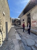
Like the nearby city of Pompeii, Herculaneum is famous as one of the few ancient cities to be preserved more or less intact, with no later accretions or modifications. The thick layer of ash that blanketed the town also protected it against looting and the elements. Unlike Pompeii, the mainly pyroclastic material that covered Herculaneum carbonized and preserved more wood in objects such as roofs, beds, and doors, as well as other organic-based materials such as food and papyrus.
In the first years after its rediscovery, tunnels were dug at the site by treasure hunters, and many artifacts were removed without authorization. Regular excavations began in 1738, and have continued ever since, albeit intermittently. Today, only part of the ancient site has been excavated, and attention and funds have shifted to the preservation of the already excavated parts of the city, rather than focusing on uncovering more areas.
Although it was smaller than Pompeii, Herculaneum was a wealthier town. It was a popular seaside retreat for the Roman elite, which is reflected in the extraordinary density of grand and luxurious houses with, for example, far more lavish use of coloured marble cladding. Famous buildings of the ancient city include the Villa of the Papyri and the so-called "boat houses", in which the skeletal remains of at least 300 people were found.
You may be viewing yesterday's version of this page. To see the most up to date information please register for a free account.
Do not use the above information on other web sites or publications without permission of the contributor.
Nearby Images from Flickr


The above images may not be of the site on this page, but were taken nearby. They are loaded from Flickr so please click on them for image credits.
Click here to see more info for this site
Nearby sites
Click here to view sites on an interactive map of the areaKey: Red: member's photo, Blue: 3rd party photo, Yellow: other image, Green: no photo - please go there and take one, Grey: site destroyed
Download sites to:
KML (Google Earth)
GPX (GPS waypoints)
CSV (Garmin/Navman)
CSV (Excel)
To unlock full downloads you need to sign up as a Contributory Member. Otherwise downloads are limited to 50 sites.
Turn off the page maps and other distractions
Nearby sites listing. In the following links * = Image available
12.8km ESE 119° Pompeii* Ancient Village or Settlement
13.2km ESE 118° Macellum of Pompeii* Modern Stone Circle etc
53.5km NW 313° Roccia San Sebastiano Cave or Rock Shelter
63.3km ESE 124° Foce del Sele Temple of Hera* Ancient Temple
69.9km SE 127° Poseidonia Temple of Athena* Ancient Temple
70.2km SE 127° Poseidonia Temple of Poseidon* Ancient Temple
70.3km SE 128° Poseidonia Temple of Hera* Ancient Temple
99.1km SE 136° Eleia Temple Ancient Temple
111.8km NNW 327° Arpino Acropolis* Ancient Village or Settlement
116.4km WNW 295° Mura Ciclopiche San Felice Circeo Stone Fort or Dun
129.7km NE 52° Daunian Arpi Ancient Village or Settlement
132.2km NW 321° Alatri Acropolis* Hillfort
134.1km NW 322° Alatri Temple* Ancient Temple
134.5km NE 51° Passo di Corvo* Henge
141.7km NE 48° Dolmen di Madonna di Cristo Burial Chamber or Dolmen
141.7km NE 47° Museo Grotta Paglicci e il Paliolitico del Gargano Museum
141.9km NE 48° Grotta Paglicci Cave or Rock Shelter
145.1km NW 307° Antica Norba* Ancient Village or Settlement
148.4km NW 312° Giunone Moneta (Segni)* Ancient Village or Settlement
156.3km NE 55° Ipogei Capparelli Ancient Village or Settlement
156.8km NE 49° Monte Calvo Ancient Village or Settlement
158.6km WNW 299° Nettuno Tomb Burial Chamber or Dolmen
160.0km NE 54° Scaloria Cavern Cave or Rock Shelter
160.7km ENE 70° Canne Standing Stone* Standing Stone (Menhir)
160.8km ENE 70° Mount of Cannae* Ancient Village or Settlement
View more nearby sites and additional images


 We would like to know more about this location. Please feel free to add a brief description and any relevant information in your own language.
 Wir möchten mehr über diese Stätte erfahren. Bitte zögern Sie nicht, eine kurze Beschreibung und relevante Informationen in Deutsch hinzuzufügen.
 Nous aimerions en savoir encore un peu sur les lieux. S'il vous plaît n'hesitez pas à ajouter une courte description et tous les renseignements pertinents dans votre propre langue.
 Quisieramos informarnos un poco más de las lugares. No dude en añadir una breve descripción y otros datos relevantes en su propio idioma.