<< Text Pages >> Es Castellot - Ancient Village or Settlement in Spain in Balearic Isles (Mallorca / Majorca)
Submitted by Anonymous on Friday, 04 August 2017 Page Views: 1359
Multi-periodSite Name: Es CastellotCountry: Spain Region: Balearic Isles (Mallorca / Majorca) Type: Ancient Village or Settlement
Nearest Town: Lloseta
Latitude: 39.726900N Longitude: 2.833300E
Condition:
| 5 | Perfect |
| 4 | Almost Perfect |
| 3 | Reasonable but with some damage |
| 2 | Ruined but still recognisable as an ancient site |
| 1 | Pretty much destroyed, possibly visible as crop marks |
| 0 | No data. |
| -1 | Completely destroyed |
| 5 | Superb |
| 4 | Good |
| 3 | Ordinary |
| 2 | Not Good |
| 1 | Awful |
| 0 | No data. |
| 5 | Can be driven to, probably with disabled access |
| 4 | Short walk on a footpath |
| 3 | Requiring a bit more of a walk |
| 2 | A long walk |
| 1 | In the middle of nowhere, a nightmare to find |
| 0 | No data. |
| 5 | co-ordinates taken by GPS or official recorded co-ordinates |
| 4 | co-ordinates scaled from a detailed map |
| 3 | co-ordinates scaled from a bad map |
| 2 | co-ordinates of the nearest village |
| 1 | co-ordinates of the nearest town |
| 0 | no data |
Internal Links:
External Links:
Ancient Village or Settlement in Balearic Isles (Mallorca / Majorca)
Megalithic settlement with defensive wall. There are a few burial caves near the ancient village.
You may be viewing yesterday's version of this page. To see the most up to date information please register for a free account.
Do not use the above information on other web sites or publications without permission of the contributor.
Nearby Images from Flickr
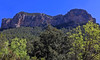
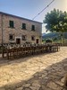
The above images may not be of the site on this page, but were taken nearby. They are loaded from Flickr so please click on them for image credits.
Click here to see more info for this site
Nearby sites
Click here to view sites on an interactive map of the areaKey: Red: member's photo, Blue: 3rd party photo, Yellow: other image, Green: no photo - please go there and take one, Grey: site destroyed
Download sites to:
KML (Google Earth)
GPX (GPS waypoints)
CSV (Garmin/Navman)
CSV (Excel)
To unlock full downloads you need to sign up as a Contributory Member. Otherwise downloads are limited to 50 sites.
Turn off the page maps and other distractions
Nearby sites listing. In the following links * = Image available
8.6km N 353° Almallutx Sanctuary* Ancient Village or Settlement
8.9km N 352° Almallutx Stone* Ancient Village or Settlement
10.1km SE 138° Son Fred* Broch or Nuraghe
10.6km SE 144° Camp del Bisbe* Cave or Rock Shelter
11.9km SE 134° Son Corro* Ancient Village or Settlement
13.2km SE 137° Binifat* Broch or Nuraghe
13.9km SE 134° Es Turassot* Ancient Village or Settlement
15.3km ESE 104° Es Racons* Broch or Nuraghe
19.6km SE 144° Son Fornes Settlement* Ancient Village or Settlement
19.7km W 266° Son Mas* Ancient Temple
20.0km W 265° The Maze, Mallorca Ancient Village or Settlement
20.2km SE 141° Campanari des Moros* Broch or Nuraghe
20.4km E 82° Talaiot de Sa Font* Broch or Nuraghe
21.4km SSE 155° Son Coll Nou Broch or Nuraghe
21.5km W 264° Son Oleza Ancient Village or Settlement
21.7km SE 143° Archaeological Museum of Son Fornés* Museum
23.1km SSW 207° Son Oms santuario* Ancient Temple
23.2km E 82° Son Serra (Can Picafort)* Ancient Village or Settlement
23.7km SW 221° Museu de Mallorca* Museum
27.3km S 175° Son Noguera* Broch or Nuraghe
27.8km NE 41° Cala Sant Vincenc* Cave or Rock Shelter
27.9km E 84° Son Bauló D'Alt* Burial Chamber or Dolmen
28.7km SE 134° Es Pagos* Broch or Nuraghe
29.9km NE 45° Bocchoris* Ancient Village or Settlement
30.0km E 84° Son Real Necropolis* Barrow Cemetery
View more nearby sites and additional images


 We would like to know more about this location. Please feel free to add a brief description and any relevant information in your own language.
 Wir möchten mehr über diese Stätte erfahren. Bitte zögern Sie nicht, eine kurze Beschreibung und relevante Informationen in Deutsch hinzuzufügen.
 Nous aimerions en savoir encore un peu sur les lieux. S'il vous plaît n'hesitez pas à ajouter une courte description et tous les renseignements pertinents dans votre propre langue.
 Quisieramos informarnos un poco más de las lugares. No dude en añadir una breve descripción y otros datos relevantes en su propio idioma.