<< Our Photo Pages >> Poblat del Puig de sa Morisca - Ancient Village or Settlement in Spain in Balearic Isles (Mallorca / Majorca)
Submitted by Ogneslav on Saturday, 08 November 2014 Page Views: 3195
Multi-periodSite Name: Poblat del Puig de sa Morisca Alternative Name: Santa Ponça 1Country: Spain
NOTE: This site is 9.582 km away from the location you searched for.
Region: Balearic Isles (Mallorca / Majorca) Type: Ancient Village or Settlement
Nearest Town: Santa Ponça
Latitude: 39.507540N Longitude: 2.480630E
Condition:
| 5 | Perfect |
| 4 | Almost Perfect |
| 3 | Reasonable but with some damage |
| 2 | Ruined but still recognisable as an ancient site |
| 1 | Pretty much destroyed, possibly visible as crop marks |
| 0 | No data. |
| -1 | Completely destroyed |
| 5 | Superb |
| 4 | Good |
| 3 | Ordinary |
| 2 | Not Good |
| 1 | Awful |
| 0 | No data. |
| 5 | Can be driven to, probably with disabled access |
| 4 | Short walk on a footpath |
| 3 | Requiring a bit more of a walk |
| 2 | A long walk |
| 1 | In the middle of nowhere, a nightmare to find |
| 0 | No data. |
| 5 | co-ordinates taken by GPS or official recorded co-ordinates |
| 4 | co-ordinates scaled from a detailed map |
| 3 | co-ordinates scaled from a bad map |
| 2 | co-ordinates of the nearest village |
| 1 | co-ordinates of the nearest town |
| 0 | no data |
Internal Links:
External Links:
I have visited· I would like to visit
43559959 would like to visit
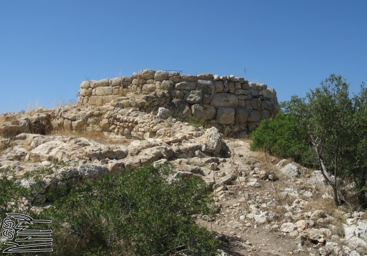
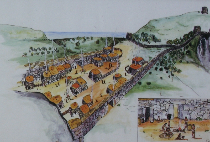
An Iron Age settlement of a complex configuration located in the Archaeological Park of Puig de sa Morisca in Santa Ponça.
Following are the reprints from several information boards installed in different places of the settlement.
Settlement at Puig de sa Morisca
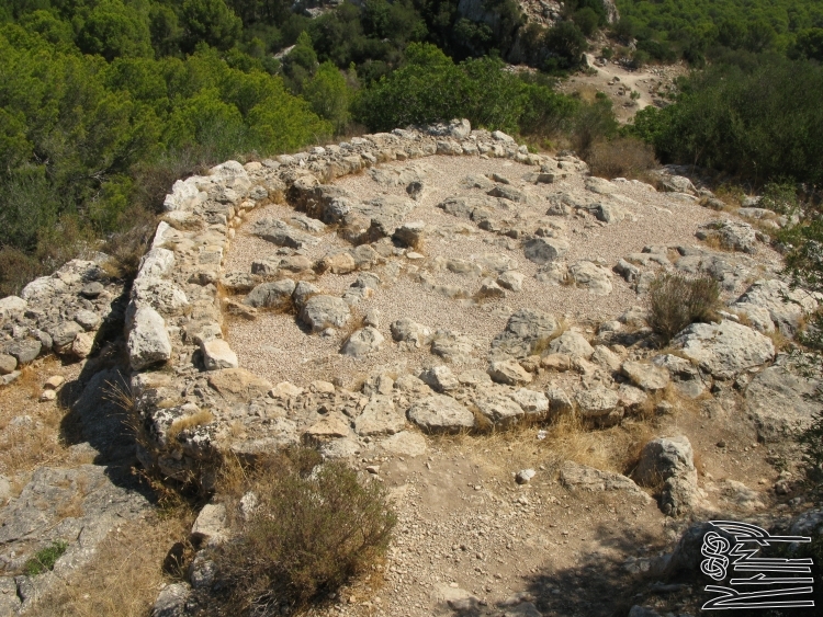
The settlement at Puig de sa Morisca, where the main part of the population of the area of Santa Ponça would have lived during the Iron Age, is situated between two rock formations and is defined by two walls which enclose it on both of the most of the most accessible sides. This kind of settlement began to appear in the Talayotic period (850-650 BC) and show signs of prolonged inhabitation which may even go beyond the end of that era. Inside there are many hand made and wheel-turned pieces of pottery, and we can make out the form of various rooms.
NW settlement sector
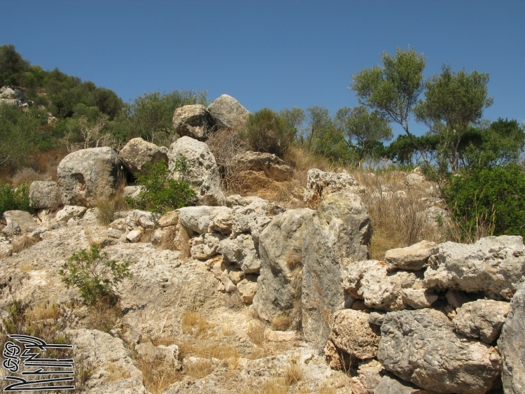
The northwest area of the settlement at Puig de sa Morisca is defined by a wall running from the hill fortifications to the rocky outcrop which encloses the settlement to the north and has a tower built into it that guards the route on this side of the settlement. Various rooms built into the outer side of this wall have also been discovered which seem to have been constructed from the stone and adobe and were inhabited from the 3rd to the 1st centuries BC. Significant pottery finds have been made in these rooms – in particular, ceramic amphora – which suggests that the area was used as a dumping ground.
SE settlement sector
The south-easterly area of the settlement at Puig de sa Morisca is defined by a wall that runs from the hill fortifications to the rocky outcrop which encloses the settlement to the north. This wall was constructed from large blocks of stone and is notable for the presence of a linteled entrance similar to that found at other sites on the island such as in Ses Païsses (Artà) . Various rooms have been discovered built into the outer and inner faces of this wall which were inhabited during the 2nd and 1st centuries BC.
Tower I
In the highest part of Puig de sa Morisca four tower were constructed. Two of the towers face north, monitoring the bay of Santa Ponça (Tower I and Tower II). The third dominated the southern area (Tower IV) , while the central tower offered a 360° field of vision (Tower III).
Tower I was built in the 7th century BC. From the 4th century BC onwards it underwent substantial remodelling, during which three spaces were created. The first served as a storage room, where Punic and Iberian amphorae were deposited. A second, very small area was used for the storage of bronxe nails next to a fire. The final space had various uses, with a fireplace area and evidence of domestic activity. At the end of the 4th century BC this tower fell into disuse, suggesting that the settlement tower-based defence system had lost its function.
Tower III at Puig de sa Morisca
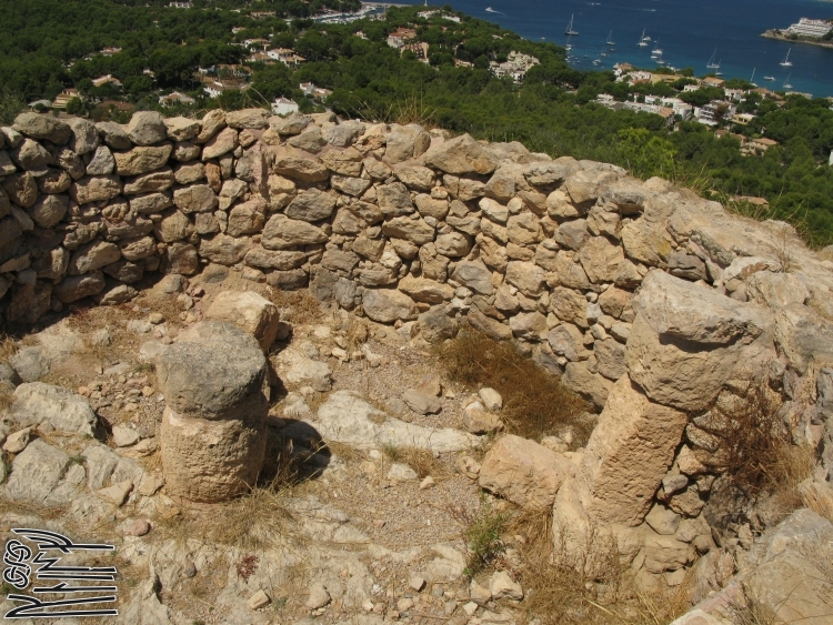
During the Talayotic period (850-650 BC) fortifications were built on the hillside at Puig de sa Morisca, such as tower III, which is located at the highest point of the hill and offers extensive views of all aspects of the surrounding area, including the sea and the natural port of Sa Caleta. The access to this turret with its walls two meters thick is undocumented, since a recent modern construction added to the inside of the tower has affected prehistoric levels and altered the original configuration of the space, leaving only a column and various coulmn drums preserved in good condition.
Restoration of tower III
Work to reinforce and restore the structure of tower III at Puig de sa Morisca was carried out following the excavation work completed in 2006. The renovation of the tower involved remounting the interior and exterior courses of the wall faces, the repositioning of one column and two pilasters, and the reinforcement of the four pilasters conserved in situ. These actions were carried out in accordance with the Law on Historic Heritage of the Balearic Islands, using reversible materials and differentiating at all times between the restored areas and the original preserved structures using a course of mortar.
You may be viewing yesterday's version of this page. To see the most up to date information please register for a free account.
Do not use the above information on other web sites or publications without permission of the contributor.
Nearby Images from Flickr


The above images may not be of the site on this page, but were taken nearby. They are loaded from Flickr so please click on them for image credits.
Click here to see more info for this site
Nearby sites
Click here to view sites on an interactive map of the areaKey: Red: member's photo, Blue: 3rd party photo, Yellow: other image, Green: no photo - please go there and take one, Grey: site destroyed
Download sites to:
KML (Google Earth)
GPX (GPS waypoints)
CSV (Garmin/Navman)
CSV (Excel)
To unlock full downloads you need to sign up as a Contributory Member. Otherwise downloads are limited to 50 sites.
Turn off the page maps and other distractions
Nearby sites listing. In the following links * = Image available
420m E 79° Santa Ponça 5* Ancient Village or Settlement
486m ESE 122° Talayot de Son Miralles* Broch or Nuraghe
542m ESE 116° Túmulo de Son Miralles* Artificial Mound
672m E 90° Santa Ponça 20* Ancient Village or Settlement
2.2km SE 135° Túmulo de Son Ferrer* Round Barrow(s)
4.1km ESE 107° Naveta Alemany* Ancient Village or Settlement
16.0km ENE 66° Museu de Mallorca* Museum
20.1km E 79° Son Oms santuario* Ancient Temple
23.7km NNE 22° Son Oleza Ancient Village or Settlement
25.0km NNE 24° The Maze, Mallorca Ancient Village or Settlement
25.3km NNE 25° Son Mas* Ancient Temple
31.9km ESE 112° Capocorb Vell* Ancient Village or Settlement
32.6km E 95° Son Noguera* Broch or Nuraghe
34.9km ESE 116° Talaies de Cala Pi* Ancient Village or Settlement
38.8km NE 51° Es Castellot Ancient Village or Settlement
39.7km E 83° Son Coll Nou Broch or Nuraghe
39.7km ENE 66° Camp del Bisbe* Cave or Rock Shelter
40.6km ENE 65° Son Fred* Broch or Nuraghe
41.9km ENE 69° Binifat* Broch or Nuraghe
42.0km ENE 67° Son Corro* Ancient Village or Settlement
42.6km ENE 78° Son Fornes Settlement* Ancient Village or Settlement
43.0km ENE 70° Es Turassot* Ancient Village or Settlement
43.9km ENE 78° Campanari des Moros* Broch or Nuraghe
44.0km NE 41° Almallutx Sanctuary* Ancient Village or Settlement
44.0km E 81° Archaeological Museum of Son Fornés* Museum
View more nearby sites and additional images


 We would like to know more about this location. Please feel free to add a brief description and any relevant information in your own language.
 Wir möchten mehr über diese Stätte erfahren. Bitte zögern Sie nicht, eine kurze Beschreibung und relevante Informationen in Deutsch hinzuzufügen.
 Nous aimerions en savoir encore un peu sur les lieux. S'il vous plaît n'hesitez pas à ajouter une courte description et tous les renseignements pertinents dans votre propre langue.
 Quisieramos informarnos un poco más de las lugares. No dude en añadir una breve descripción y otros datos relevantes en su propio idioma.