<< Our Photo Pages >> Monte Idda Nuraghe - Broch or Nuraghe in Italy in Sardinia (Sardegna)
Submitted by SolarMegalith on Wednesday, 11 May 2022 Page Views: 348
Neolithic and Bronze AgeSite Name: Monte Idda Nuraghe Alternative Name: Nuraghe Monte Sa IddaCountry: Italy
NOTE: This site is 5.643 km away from the location you searched for.
Region: Sardinia (Sardegna) Type: Broch or Nuraghe
Nearest Town: Decimoputzu
Latitude: 39.314685N Longitude: 8.861103E
Condition:
| 5 | Perfect |
| 4 | Almost Perfect |
| 3 | Reasonable but with some damage |
| 2 | Ruined but still recognisable as an ancient site |
| 1 | Pretty much destroyed, possibly visible as crop marks |
| 0 | No data. |
| -1 | Completely destroyed |
| 5 | Superb |
| 4 | Good |
| 3 | Ordinary |
| 2 | Not Good |
| 1 | Awful |
| 0 | No data. |
| 5 | Can be driven to, probably with disabled access |
| 4 | Short walk on a footpath |
| 3 | Requiring a bit more of a walk |
| 2 | A long walk |
| 1 | In the middle of nowhere, a nightmare to find |
| 0 | No data. |
| 5 | co-ordinates taken by GPS or official recorded co-ordinates |
| 4 | co-ordinates scaled from a detailed map |
| 3 | co-ordinates scaled from a bad map |
| 2 | co-ordinates of the nearest village |
| 1 | co-ordinates of the nearest town |
| 0 | no data |
Internal Links:
External Links:
I have visited· I would like to visit
SolarMegalith visited on 21st Sep 2021 - their rating: Cond: 2 Amb: 5 Access: 3
")
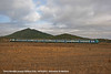
Nuraghe Monte Idda occupies the summit of a hill east of Decimoputzu, near the confine with Siliqua. It is a single-towered nuraghe bult of granite blocks. The tholos chamber partly survived, the outer wall-face is best preserved in eastern part of the structure.
You may be viewing yesterday's version of this page. To see the most up to date information please register for a free account.
")
")
Do not use the above information on other web sites or publications without permission of the contributor.
Nearby Images from Flickr
The above images may not be of the site on this page, but were taken nearby. They are loaded from Flickr so please click on them for image credits.
Click here to see more info for this site
Nearby sites
Click here to view sites on an interactive map of the areaKey: Red: member's photo, Blue: 3rd party photo, Yellow: other image, Green: no photo - please go there and take one, Grey: site destroyed
Download sites to:
KML (Google Earth)
GPX (GPS waypoints)
CSV (Garmin/Navman)
CSV (Excel)
To unlock full downloads you need to sign up as a Contributory Member. Otherwise downloads are limited to 50 sites.
Turn off the page maps and other distractions
Nearby sites listing. In the following links * = Image available
3.5km NNW 331° Fundali Fanaris de Jossu Nuraghe* Broch or Nuraghe
3.9km NNW 332° Casteddu de Fanaris Complesso Nuragico* Broch or Nuraghe
11.0km NNW 335° Monte Zippiri Nuraghe* Broch or Nuraghe
13.9km SSE 151° Serra Is Cabbias Nuraghe* Broch or Nuraghe
14.3km W 266° Cuccuru 'e Sa Funtana Nuraghe Broch or Nuraghe
15.9km WNW 293° Matzanni* Holy Well or Sacred Spring
17.2km WNW 301° Genna Uraxi Nuraghe Broch or Nuraghe
17.7km WSW 253° Bia Arrubia Nuraghe Broch or Nuraghe
17.9km ENE 66° Bia 'e Monti Insediamento Nuragico* Ancient Village or Settlement
18.0km ENE 65° Monte Zara Domus de Janas* Rock Cut Tomb
18.1km NNE 17° Cuccuru Sa Uga Nuraghe Broch or Nuraghe
18.5km WSW 239° Monte Scorra Nuraghe Broch or Nuraghe
19.0km W 273° S'Omu 'e s'Orku Nuraghe* Broch or Nuraghe
19.8km SE 135° Cuccuru Ibba Nuraghe* Broch or Nuraghe
20.2km WSW 255° Santu Pauli Nuraghe* Broch or Nuraghe
20.2km S 177° Is Fanebas Nuraghe* Broch or Nuraghe
20.8km NE 36° Monte Leonaxi Complesso Nuragico* Broch or Nuraghe
21.3km NNE 25° Bruncu Su Castiu Nuraghe Broch or Nuraghe
21.6km NE 38° Serra Cannigas Nuraghe* Broch or Nuraghe
21.7km NE 37° Sa Corona Protonuraghe* Broch or Nuraghe
22.1km NE 35° Monte Cuamnaxi Protonuraghe Broch or Nuraghe
22.1km SSW 213° Ega Is Marsinis Nuraghe* Broch or Nuraghe
22.3km SW 214° Pranedda Domus de Janas* Rock Cut Tomb
22.5km NNE 30° Monti Atziadei Protonuraghe Broch or Nuraghe
22.8km ESE 115° Necropoli fenicio-punica di Tuvixeddu* Rock Cut Tomb
View more nearby sites and additional images


 We would like to know more about this location. Please feel free to add a brief description and any relevant information in your own language.
 Wir möchten mehr über diese Stätte erfahren. Bitte zögern Sie nicht, eine kurze Beschreibung und relevante Informationen in Deutsch hinzuzufügen.
 Nous aimerions en savoir encore un peu sur les lieux. S'il vous plaît n'hesitez pas à ajouter une courte description et tous les renseignements pertinents dans votre propre langue.
 Quisieramos informarnos un poco más de las lugares. No dude en añadir una breve descripción y otros datos relevantes en su propio idioma.