<< Our Photo Pages >> Sultan Hani Stele - Rock Art in Turkey
Submitted by AlexHunger on Tuesday, 02 October 2007 Page Views: 4070
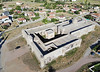
Rock ArtSite Name: Sultan Hani SteleCountry: Turkey
NOTE: This site is 24.206 km away from the location you searched for.
Type: Rock Art
Nearest Town: Sultan Hanı
Latitude: 38.975812N Longitude: 35.894465E
Condition:
| 5 | Perfect |
| 4 | Almost Perfect |
| 3 | Reasonable but with some damage |
| 2 | Ruined but still recognisable as an ancient site |
| 1 | Pretty much destroyed, possibly visible as crop marks |
| 0 | No data. |
| -1 | Completely destroyed |
| 5 | Superb |
| 4 | Good |
| 3 | Ordinary |
| 2 | Not Good |
| 1 | Awful |
| 0 | No data. |
| 5 | Can be driven to, probably with disabled access |
| 4 | Short walk on a footpath |
| 3 | Requiring a bit more of a walk |
| 2 | A long walk |
| 1 | In the middle of nowhere, a nightmare to find |
| 0 | No data. |
| 5 | co-ordinates taken by GPS or official recorded co-ordinates |
| 4 | co-ordinates scaled from a detailed map |
| 3 | co-ordinates scaled from a bad map |
| 2 | co-ordinates of the nearest village |
| 1 | co-ordinates of the nearest town |
| 0 | no data |
Internal Links:
External Links:
")
Hittite Stele taken from its original location, now in the Ankara Museum. Another one, in worse condition, is said to be still in its original location.
Exact location unknown, position to nearest town.
You may be viewing yesterday's version of this page. To see the most up to date information please register for a free account.
")
Do not use the above information on other web sites or publications without permission of the contributor.
Nearby Images from Flickr


The above images may not be of the site on this page, but were taken nearby. They are loaded from Flickr so please click on them for image credits.
Click here to see more info for this site
Nearby sites
Click here to view sites on an interactive map of the areaKey: Red: member's photo, Blue: 3rd party photo, Yellow: other image, Green: no photo - please go there and take one, Grey: site destroyed
Download sites to:
KML (Google Earth)
GPX (GPS waypoints)
CSV (Garmin/Navman)
CSV (Excel)
To unlock full downloads you need to sign up as a Contributory Member. Otherwise downloads are limited to 50 sites.
Turn off the page maps and other distractions
Nearby sites listing. In the following links * = Image available
25.9km WSW 238° Karum Kanes* Ancient Village or Settlement
26.4km WSW 238° Kültepe Kanes* Ancient Village or Settlement
45.1km SW 231° Kayseri Archaeological Museum* Museum
64.9km WSW 242° Örenşehir* Ancient Village or Settlement
73.0km NW 322° Sarikaya Roman Bath* Ancient Village or Settlement
73.1km E 98° Karakuyu Hittite Dam* Ancient Mine, Quarry or other Industry
81.1km S 178° Imamkullu* Carving
81.1km SSE 152° Comana Chryse* Ancient Village or Settlement
81.9km SSW 196° Fraktin* Carving
85.4km S 173° Gezbeli* Carving
88.8km NW 322° Alisar Hoyuk* Ancient Village or Settlement
90.0km NE 37° Kayalipinar Ancient Village or Settlement
92.4km W 273° Topakli Hoyuk Ancient Village or Settlement
95.0km ENE 67° Sarissa Ancient Village or Settlement
96.8km WSW 249° Rock Cones of Urgup (Cappadocia)* Natural Stone / Erratic / Other Natural Feature
98.6km SW 235° Sobessos* Ancient Village or Settlement
101.2km NW 321° Cadir Hoyuk* Ancient Village or Settlement
103.5km NNW 334° Karakiz* Carving
109.7km WSW 249° Nevsehir Underground City* Cave or Rock Shelter
112.1km NW 320° Kerkenes Ancient Village or Settlement
113.1km WSW 257° Arapsun* Ancient Village or Settlement
114.5km WSW 240° Kaymakli Underground City* Ancient Village or Settlement
117.9km NW 322° Usakli Mound* Ancient Village or Settlement
120.9km WSW 237° Derinkuyu Underground City* Ancient Village or Settlement
125.0km W 266° Karaburna* Carving
View more nearby sites and additional images


 We would like to know more about this location. Please feel free to add a brief description and any relevant information in your own language.
 Wir möchten mehr über diese Stätte erfahren. Bitte zögern Sie nicht, eine kurze Beschreibung und relevante Informationen in Deutsch hinzuzufügen.
 Nous aimerions en savoir encore un peu sur les lieux. S'il vous plaît n'hesitez pas à ajouter une courte description et tous les renseignements pertinents dans votre propre langue.
 Quisieramos informarnos un poco más de las lugares. No dude en añadir una breve descripción y otros datos relevantes en su propio idioma.