<< Our Photo Pages >> Panarea Capo Graciano - Ancient Village or Settlement in Italy in Sicily (Sicilia)
Submitted by AlexHunger on Sunday, 27 August 2006 Page Views: 6657
Multi-periodSite Name: Panarea Capo GracianoCountry: Italy
NOTE: This site is 31.324 km away from the location you searched for.
Region: Sicily (Sicilia) Type: Ancient Village or Settlement
Nearest Town: Messina Nearest Village: Panarea
Latitude: 38.626839N Longitude: 15.058184E
Condition:
| 5 | Perfect |
| 4 | Almost Perfect |
| 3 | Reasonable but with some damage |
| 2 | Ruined but still recognisable as an ancient site |
| 1 | Pretty much destroyed, possibly visible as crop marks |
| 0 | No data. |
| -1 | Completely destroyed |
| 5 | Superb |
| 4 | Good |
| 3 | Ordinary |
| 2 | Not Good |
| 1 | Awful |
| 0 | No data. |
| 5 | Can be driven to, probably with disabled access |
| 4 | Short walk on a footpath |
| 3 | Requiring a bit more of a walk |
| 2 | A long walk |
| 1 | In the middle of nowhere, a nightmare to find |
| 0 | No data. |
| 5 | co-ordinates taken by GPS or official recorded co-ordinates |
| 4 | co-ordinates scaled from a detailed map |
| 3 | co-ordinates scaled from a bad map |
| 2 | co-ordinates of the nearest village |
| 1 | co-ordinates of the nearest town |
| 0 | no data |
Internal Links:
External Links:
I have visited· I would like to visit
43559959 would like to visit
")
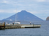
Remains of 1300 BCE Beehive huts on Panarea Island, Capo Graciano north of Sicilly.
Important note: Exact position unknown, GPS position to nearest village.
You may be viewing yesterday's version of this page. To see the most up to date information please register for a free account.
")
")
Do not use the above information on other web sites or publications without permission of the contributor.
Nearby Images from Flickr
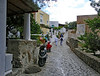
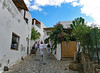
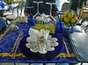


The above images may not be of the site on this page, but were taken nearby. They are loaded from Flickr so please click on them for image credits.
Click here to see more info for this site
Nearby sites
Click here to view sites on an interactive map of the areaKey: Red: member's photo, Blue: 3rd party photo, Yellow: other image, Green: no photo - please go there and take one, Grey: site destroyed
Download sites to:
KML (Google Earth)
GPX (GPS waypoints)
CSV (Garmin/Navman)
CSV (Excel)
To unlock full downloads you need to sign up as a Contributory Member. Otherwise downloads are limited to 50 sites.
Turn off the page maps and other distractions
Nearby sites listing. In the following links * = Image available
41.4km W 259° Filicudi Island Settlement* Ancient Village or Settlement
53.7km S 181° Tindari* Ancient Village or Settlement
64.5km S 177° The rocky millstones of Tripi Ancient Mine, Quarry or other Industry
65.3km SSE 164° Rocca Timogna* Rock Outcrop
67.6km S 173° Rocca Nkravaccada* Natural Stone / Erratic / Other Natural Feature
70.7km S 174° Rocca Salvatesta* Rock Outcrop
70.7km S 174° La Valle di Levante* Natural Stone / Erratic / Other Natural Feature
70.9km S 181° Megaliti dell'Argimusco* Natural Stone / Erratic / Other Natural Feature
71.0km S 172° Pizzo Vento* Natural Stone / Erratic / Other Natural Feature
72.3km S 172° Grotta Grottona* Cave or Rock Shelter
88.5km SSE 167° Taormina* Ancient Village or Settlement
91.6km E 86° Hipponion Temples Ancient Temple
98.8km SW 225° Halaesa* Ancient Village or Settlement
111.4km SW 234° Cefalu Temple of Artemis* Ancient Temple
111.8km ESE 114° Locri Epizephyrii Ancient Village or Settlement
112.8km ESE 114° Locri Epizefiri* Ancient Village or Settlement
116.7km ESE 108° Marina di Gioiosa Jonica* Ancient Village or Settlement
129.9km WSW 236° Himera Temple* Ancient Temple
129.9km WSW 236° Gela Temples Ancient Temple
133.7km E 98° Museo Archeologico di Monasterace Museum
133.8km E 98° Kaulonia Ancient Village or Settlement
133.8km E 98° Caulonia* Ancient Village or Settlement
134.8km E 81° Scolacium* Ancient Temple
135.5km WSW 237° Mura Pregne dolmen (Sicily)* Burial Chamber or Dolmen
142.4km SSW 201° Morgantina* Ancient Village or Settlement
View more nearby sites and additional images


 We would like to know more about this location. Please feel free to add a brief description and any relevant information in your own language.
 Wir möchten mehr über diese Stätte erfahren. Bitte zögern Sie nicht, eine kurze Beschreibung und relevante Informationen in Deutsch hinzuzufügen.
 Nous aimerions en savoir encore un peu sur les lieux. S'il vous plaît n'hesitez pas à ajouter une courte description et tous les renseignements pertinents dans votre propre langue.
 Quisieramos informarnos un poco más de las lugares. No dude en añadir una breve descripción y otros datos relevantes en su propio idioma.