<< Other Photo Pages >> Stone Serpent Mound - Hill Figure or Geoglyph in United States in Great Lakes Midwest
Submitted by AKFisher on Wednesday, 30 August 2023 Page Views: 670
Pre-ColumbianSite Name: Stone Serpent Mound Alternative Name: Kentucky Stone Serpent Mound, 15Bd6Country: United States Region: Great Lakes Midwest Type: Hill Figure or Geoglyph
Nearest Town: Catlettsburg, KY
Latitude: 38.353020N Longitude: 82.600985W
Condition:
| 5 | Perfect |
| 4 | Almost Perfect |
| 3 | Reasonable but with some damage |
| 2 | Ruined but still recognisable as an ancient site |
| 1 | Pretty much destroyed, possibly visible as crop marks |
| 0 | No data. |
| -1 | Completely destroyed |
| 5 | Superb |
| 4 | Good |
| 3 | Ordinary |
| 2 | Not Good |
| 1 | Awful |
| 0 | No data. |
| 5 | Can be driven to, probably with disabled access |
| 4 | Short walk on a footpath |
| 3 | Requiring a bit more of a walk |
| 2 | A long walk |
| 1 | In the middle of nowhere, a nightmare to find |
| 0 | No data. |
| 5 | co-ordinates taken by GPS or official recorded co-ordinates |
| 4 | co-ordinates scaled from a detailed map |
| 3 | co-ordinates scaled from a bad map |
| 2 | co-ordinates of the nearest village |
| 1 | co-ordinates of the nearest town |
| 0 | no data |
Be the first person to rate this site - see the 'Contribute!' box in the right hand menu.
Internal Links:
External Links:
")
Ohio's Serpent Mound is the most famous of American effigy mounds. However, it is not the only remaining serpent effigy. Stone Serpent Mound, one of three serpent stone effigies known in Kentucky, is now famous in archaeology but remains little-known to the public. The effigy was constructed on a steep hill adjacent to a modern oil refinery and appears to have been first officially reported in 1976. A large semi-circle of stone appears to represent an egg at the serpent's head. The stone forming the major portion of the snake is piled to a height of 12 feet. As the head and tail are reached, the height of the stone formation is 4 feet with a width of 5 feet. The exact length has not been reported. Archaeologists date the formation to as early as 1000 BCE, and to as recent as 1000 CE.[1]
Reference:
1. Description courtesy of Dr. Greg Little, author of the Illustrated Encyclopedia of Native American Indian Mounds & Earthworks (2016), pp 157.
Further reading and information:
People of the Stone
peopleofthestone.com/mystery-stone-mounds<2>
JSTOR
http://www.jstor.org/stable/20708318<4>
Directions:
This site is on private property. Please gain owner permission when accessing sites on private property. Approximate location is given above in LAT/LONG and is an estimate based on current information from sources.
You may be viewing yesterday's version of this page. To see the most up to date information please register for a free account.
Do not use the above information on other web sites or publications without permission of the contributor.
Nearby Images from Flickr

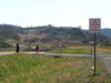
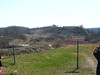

The above images may not be of the site on this page, but were taken nearby. They are loaded from Flickr so please click on them for image credits.
Click here to see more info for this site
Nearby sites
Click here to view sites on an interactive map of the areaKey: Red: member's photo, Blue: 3rd party photo, Yellow: other image, Green: no photo - please go there and take one, Grey: site destroyed
Download sites to:
KML (Google Earth)
GPX (GPS waypoints)
CSV (Garmin/Navman)
CSV (Excel)
To unlock full downloads you need to sign up as a Contributory Member. Otherwise downloads are limited to 50 sites.
Turn off the page maps and other distractions
Nearby sites listing. In the following links * = Image available
54.4km NW 323° Portsmouth Earthworks* Misc. Earthwork
56.5km NE 40° May Moore Mound* Misc. Earthwork
61.3km NW 325° Tremper* Barrow Cemetery
73.3km E 88° Dunbar Mound* Barrow Cemetery
76.6km E 89° Sunset Mound Artificial Mound
78.8km E 88° Criel Mound* Barrow Cemetery
85.8km NNW 335° Piketon Mounds* Artificial Mound
103.5km NNW 347° Liberty Earthworks* Artificial Mound
103.6km NW 316° Serpent Mound, Ohio* Artificial Mound
103.8km NW 316° Serpent Mound Stone Standing Stone (Menhir)
107.4km NNW 345° High Bank Works* Misc. Earthwork
109.8km NW 321° Fort Hill* Hillfort
111.3km NNW 335° Baum Earthworks* Artificial Mound
112.1km NNW 332° Seip Mound* Artificial Mound
112.1km NNW 332° Seip Earthwork Enclosure* Misc. Earthwork
112.4km NNW 336° Spruce Hill* Vitrified Fort
112.9km NNW 342° Junction Earthworks* Misc. Earthwork
114.1km NNW 341° Steel Earthworks* Misc. Earthwork
115.2km W 281° Shannon Mound* Artificial Mound
115.3km NNW 343° Story Mound (Chillicothe)* Artificial Mound
116.8km ESE 104° Armstrong Mountain* Artificial Mound
117.0km NNW 343° Adena Mound* Artificial Mound
119.0km NNW 343° Hopewell Culture National Historic Site* Misc. Earthwork
119.5km NNW 344° Hopeton Earthworks* Artificial Mound
119.8km NNW 339° Hopewell Mound Group* Artificial Mound
View more nearby sites and additional images


 We would like to know more about this location. Please feel free to add a brief description and any relevant information in your own language.
 Wir möchten mehr über diese Stätte erfahren. Bitte zögern Sie nicht, eine kurze Beschreibung und relevante Informationen in Deutsch hinzuzufügen.
 Nous aimerions en savoir encore un peu sur les lieux. S'il vous plaît n'hesitez pas à ajouter une courte description et tous les renseignements pertinents dans votre propre langue.
 Quisieramos informarnos un poco más de las lugares. No dude en añadir una breve descripción y otros datos relevantes en su propio idioma.