<< Our Photo Pages >> Cava D'Ispica - Rock Cut Tomb in Italy in Sicily (Sicilia)
Submitted by Armand on Friday, 21 December 2018 Page Views: 1080
Multi-periodSite Name: Cava D''IspicaCountry: Italy
NOTE: This site is 51.201 km away from the location you searched for.
Region: Sicily (Sicilia) Type: Rock Cut Tomb
Nearest Town: Modica
Latitude: 36.852700N Longitude: 14.837590E
Condition:
| 5 | Perfect |
| 4 | Almost Perfect |
| 3 | Reasonable but with some damage |
| 2 | Ruined but still recognisable as an ancient site |
| 1 | Pretty much destroyed, possibly visible as crop marks |
| 0 | No data. |
| -1 | Completely destroyed |
| 5 | Superb |
| 4 | Good |
| 3 | Ordinary |
| 2 | Not Good |
| 1 | Awful |
| 0 | No data. |
| 5 | Can be driven to, probably with disabled access |
| 4 | Short walk on a footpath |
| 3 | Requiring a bit more of a walk |
| 2 | A long walk |
| 1 | In the middle of nowhere, a nightmare to find |
| 0 | No data. |
| 5 | co-ordinates taken by GPS or official recorded co-ordinates |
| 4 | co-ordinates scaled from a detailed map |
| 3 | co-ordinates scaled from a bad map |
| 2 | co-ordinates of the nearest village |
| 1 | co-ordinates of the nearest town |
| 0 | no data |
Internal Links:
External Links:
")
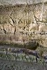
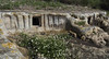
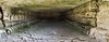
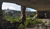
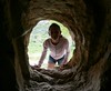
The Cava d'Ispica (Cave of Ispica) consists of a series of housing units carved in rocky formations. Built prior to the Greek colonization, these houses were used until the end of the nineteenth century.
http://www.regione.sicilia.it/beniculturali/dirbenicult/database/page_musei/pagina_musei.asp?ID=52&IdSito=69
You may be viewing yesterday's version of this page. To see the most up to date information please register for a free account.
")
")
")
Do not use the above information on other web sites or publications without permission of the contributor.
Nearby Images from Flickr
The above images may not be of the site on this page, but were taken nearby. They are loaded from Flickr so please click on them for image credits.
Click here to see more info for this site
Nearby sites
Click here to view sites on an interactive map of the areaKey: Red: member's photo, Blue: 3rd party photo, Yellow: other image, Green: no photo - please go there and take one, Grey: site destroyed
Download sites to:
KML (Google Earth)
GPX (GPS waypoints)
CSV (Garmin/Navman)
CSV (Excel)
To unlock full downloads you need to sign up as a Contributory Member. Otherwise downloads are limited to 50 sites.
Turn off the page maps and other distractions
Nearby sites listing. In the following links * = Image available
6.1km ENE 66° Cava Lazzaro* Burial Chamber or Dolmen
7.7km N 352° Cava dei Servi* Burial Chamber or Dolmen
14.8km NE 35° Castelluccio Necropolis Rock Cut Tomb
19.5km ENE 58° Noto antica* Ancient Village or Settlement
23.1km NNE 14° Santoni* Carving
23.4km NNE 13° Akrai* Ancient Village or Settlement
29.7km ENE 73° Dolmen di Avola* Natural Stone / Erratic / Other Natural Feature
29.9km N 3° The neviere of Buccheri* Artificial Mound
34.8km W 274° Kamarina Ancient Village or Settlement
35.3km NNE 27° Pantalica Rock Cut Tombs* Rock Cut Tomb
35.5km NNE 28° The Anaktoron Palace* Ancient Palace
43.7km ENE 59° Syracuse Temple of Olympian Zeus Ancient Temple
46.1km ENE 58° Syracuse Archaeological Park* Museum
46.6km ENE 60° Ortigia Temple of Athena* Ancient Temple
46.8km ENE 60° Ortigia Temple of Apollo* Ancient Temple
46.9km ENE 59° Paolo Orsi Museo Archeologico Museum
49.6km NE 38° Megara Hyblaea* Ancient Village or Settlement
56.6km WNW 295° Archaeological museum (Gela)* Museum
59.2km WNW 295° Bagni Greci* Ancient Village or Settlement
59.7km WNW 294° Capo Soprano* Hillfort
62.4km NW 315° Monte Bubbonia* Chambered Tomb
71.6km NNW 334° Morgantina* Ancient Village or Settlement
72.3km NW 322° Villa imperiale del Casale* Ancient Palace
100.6km SSW 211° Ghajn Damma Stone Row* Stone Row / Alignment
101.1km SSW 211° Ghajn Damma Stones* Standing Stones
View more nearby sites and additional images


 We would like to know more about this location. Please feel free to add a brief description and any relevant information in your own language.
 Wir möchten mehr über diese Stätte erfahren. Bitte zögern Sie nicht, eine kurze Beschreibung und relevante Informationen in Deutsch hinzuzufügen.
 Nous aimerions en savoir encore un peu sur les lieux. S'il vous plaît n'hesitez pas à ajouter une courte description et tous les renseignements pertinents dans votre propre langue.
 Quisieramos informarnos un poco más de las lugares. No dude en añadir una breve descripción y otros datos relevantes en su propio idioma.