<< Our Photo Pages >> Iol. - Ancient Village or Settlement in Algeria
Submitted by AlexHunger on Friday, 18 April 2008 Page Views: 5223
Multi-periodSite Name: Iol. Alternative Name: JolCountry: Algeria
NOTE: This site is 187.886 km away from the location you searched for.
Type: Ancient Village or Settlement
Nearest Town: Cherchell Nearest Village: Cherchell
Latitude: 36.605318N Longitude: 2.190366E
Condition:
| 5 | Perfect |
| 4 | Almost Perfect |
| 3 | Reasonable but with some damage |
| 2 | Ruined but still recognisable as an ancient site |
| 1 | Pretty much destroyed, possibly visible as crop marks |
| 0 | No data. |
| -1 | Completely destroyed |
| 5 | Superb |
| 4 | Good |
| 3 | Ordinary |
| 2 | Not Good |
| 1 | Awful |
| 0 | No data. |
| 5 | Can be driven to, probably with disabled access |
| 4 | Short walk on a footpath |
| 3 | Requiring a bit more of a walk |
| 2 | A long walk |
| 1 | In the middle of nowhere, a nightmare to find |
| 0 | No data. |
| 5 | co-ordinates taken by GPS or official recorded co-ordinates |
| 4 | co-ordinates scaled from a detailed map |
| 3 | co-ordinates scaled from a bad map |
| 2 | co-ordinates of the nearest village |
| 1 | co-ordinates of the nearest town |
| 0 | no data |
Internal Links:
External Links:
I have visited· I would like to visit
SimonBlackmore has visited here
")
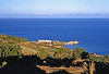
The Phoenicians of Carthage settled in Iol or Jol, a large and important seaport, in the 4th century BCE. The town then became a part of the kingdom of Numidia under Jugurtha, who was executed by Rome in 104 BCE. Under roman rule. it then became known as Caesarea and has various splendid temples and monuments from the Punic, Numidian and Roman periods. Fragments remain of a white marble temple.
The coordinates are being given for the ancient theater.
You may be viewing yesterday's version of this page. To see the most up to date information please register for a free account.
Do not use the above information on other web sites or publications without permission of the contributor.
Nearby Images from Flickr

The above images may not be of the site on this page, but were taken nearby. They are loaded from Flickr so please click on them for image credits.
Click here to see more info for this site
Nearby sites
Click here to view sites on an interactive map of the areaKey: Red: member's photo, Blue: 3rd party photo, Yellow: other image, Green: no photo - please go there and take one, Grey: site destroyed
Download sites to:
KML (Google Earth)
GPX (GPS waypoints)
CSV (Garmin/Navman)
CSV (Excel)
To unlock full downloads you need to sign up as a Contributory Member. Otherwise downloads are limited to 50 sites.
Turn off the page maps and other distractions
Nearby sites listing. In the following links * = Image available
22.6km E 93° Tefessedt* Ancient Village or Settlement
32.6km E 96° Tombeau de la Chrétienne* Pyramid / Mastaba
78.3km ENE 77° Ikosim Ancient Village or Settlement
244.8km NNW 345° Ca Na Costa* Passage Grave
262.5km NNW 344° Sa Caleta Ancient Village or Settlement
263.6km NNW 345° Pou Roig* Holy Well or Sacred Spring
264.6km NNW 346° Puig Des Molins* Museum
265.6km NNW 343° Font den Xiquet* Holy Well or Sacred Spring
269.3km NNW 344° Font de Verger* Holy Well or Sacred Spring
275.3km NNW 345° Pou de Forada* Holy Well or Sacred Spring
275.5km NNW 349° Font de Peralta* Holy Well or Sacred Spring
277.0km NNW 347° Font de Balafi* Holy Well or Sacred Spring
277.4km NNW 347° Pou d’Albarqueta Holy Well or Sacred Spring
280.5km NNW 348° Pou de Labritja* Holy Well or Sacred Spring
280.6km N 349° Cova d'Es Cuieram Cave or Rock Shelter
281.7km NNW 346° Font des ses Torres Holy Well or Sacred Spring
281.8km NNW 348° Pou des Baladre* Holy Well or Sacred Spring
294.6km E 98° Dejmila* Ancient Village or Settlement
301.3km NW 304° La Fonteta* Ancient Village or Settlement
310.6km NNE 15° Punta des Baus* Ancient Village or Settlement
312.3km NNE 14° Ets Antigors* Ancient Village or Settlement
312.9km N 10° Talaies de Cala Pi* Ancient Village or Settlement
313.0km NW 306° L'Alcúdia* Ancient Village or Settlement
315.4km N 10° Capocorb Vell* Ancient Village or Settlement
315.5km NNE 12° Talaiot de Ca n'Estela* Broch or Nuraghe
View more nearby sites and additional images


 We would like to know more about this location. Please feel free to add a brief description and any relevant information in your own language.
 Wir möchten mehr über diese Stätte erfahren. Bitte zögern Sie nicht, eine kurze Beschreibung und relevante Informationen in Deutsch hinzuzufügen.
 Nous aimerions en savoir encore un peu sur les lieux. S'il vous plaît n'hesitez pas à ajouter une courte description et tous les renseignements pertinents dans votre propre langue.
 Quisieramos informarnos un poco más de las lugares. No dude en añadir una breve descripción y otros datos relevantes en su propio idioma.