<< Our Photo Pages >> Hashigui-iwa - Natural Stone / Erratic / Other Natural Feature in Japan in Honshū
Submitted by Aska on Saturday, 21 June 2014 Page Views: 3027
Natural PlacesSite Name: Hashigui-iwa Alternative Name: 橋杭岩Country: Japan
NOTE: This site is 21.95 km away from the location you searched for.
Region: Honshū Type: Natural Stone / Erratic / Other Natural Feature
Nearest Town: Kushimoto-chō (Wakayama pref.) Nearest Village: Kujinokawa 鬮野川
Latitude: 33.488370N Longitude: 135.794690E
Condition:
| 5 | Perfect |
| 4 | Almost Perfect |
| 3 | Reasonable but with some damage |
| 2 | Ruined but still recognisable as an ancient site |
| 1 | Pretty much destroyed, possibly visible as crop marks |
| 0 | No data. |
| -1 | Completely destroyed |
| 5 | Superb |
| 4 | Good |
| 3 | Ordinary |
| 2 | Not Good |
| 1 | Awful |
| 0 | No data. |
| 5 | Can be driven to, probably with disabled access |
| 4 | Short walk on a footpath |
| 3 | Requiring a bit more of a walk |
| 2 | A long walk |
| 1 | In the middle of nowhere, a nightmare to find |
| 0 | No data. |
| 5 | co-ordinates taken by GPS or official recorded co-ordinates |
| 4 | co-ordinates scaled from a detailed map |
| 3 | co-ordinates scaled from a bad map |
| 2 | co-ordinates of the nearest village |
| 1 | co-ordinates of the nearest town |
| 0 | no data |
Internal Links:
External Links:
")
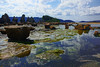
Hashi(=bridge)+Gui(kui=pier)+Iwa(=rocks).
Magma had penetrated the cracks in the stratum, tidal waves washed away the soft stratum then hard igneous rocks remain like bridge piers.
The piers seem to reach Ōshima (大島) island where the wreckage of the Turkish frigate Ertuğrul occurred. The rescue of the foreign victims is the origin of the everlasting friendship between Japan and Turkey, the Turkish Airlines rescued the isolated Japanese resident workers in Tehran after Saddam Hussein's declaration of anti-aircraft fire, as the returning gratitude for the event 95 years ago.
You may be viewing yesterday's version of this page. To see the most up to date information please register for a free account.
")
Do not use the above information on other web sites or publications without permission of the contributor.
Nearby Images from Flickr

The above images may not be of the site on this page, but were taken nearby. They are loaded from Flickr so please click on them for image credits.
Click here to see more info for this site
Nearby sites
Click here to view sites on an interactive map of the areaKey: Red: member's photo, Blue: 3rd party photo, Yellow: other image, Green: no photo - please go there and take one, Grey: site destroyed
Download sites to:
KML (Google Earth)
GPX (GPS waypoints)
CSV (Garmin/Navman)
CSV (Excel)
To unlock full downloads you need to sign up as a Contributory Member. Otherwise downloads are limited to 50 sites.
Turn off the page maps and other distractions
Nearby sites listing. In the following links * = Image available
65.8km NE 34° Kumano-no Shishigaki* Hillfort
74.5km NW 310° Dōjō-ji temple* Modern Stone Circle etc
92.8km NW 324° Jōkoku-ji temple* Modern Stone Circle etc
95.1km NNW 338° Kokawa-dera temple* Modern Stone Circle etc
95.2km NNW 338° JūzenRitsu-in temple* Modern Stone Circle etc
95.2km N 9° Miya-no-Taira* Stone Circle
95.7km N 355° Kongō-ji temple* Modern Stone Circle etc
98.0km N 360° Gangyō-ji temple* Modern Stone Circle etc
104.4km N 1° Gohyaku-Rakan of Tsubosaka-dera temple* Sculptured Stone
105.0km NW 326° Fujito-dai residential town* Modern Stone Circle etc
105.2km N 2° Saruishi (in Takatori town)* Sculptured Stone
106.3km N 357° Muro Miyayama Kofun* Long Barrow
107.0km N 1° Kitora Kofun* Passage Grave
107.1km N 0° Jintōseki* Sculptured Stone
107.4km N 1° Ryūfuku-ji temple* Ancient Temple
107.4km NNW 347° Mani-in temple* Modern Stone Circle etc
107.5km NNW 347° Amanōsan Kongō-ji temple* Modern Stone Circle etc
107.6km N 1° Iwabashi* Ancient Trackway
107.6km NNW 333° Rinshō-ji temple* Modern Stone Circle etc
107.6km N 360° Tsukamyōjin kofun* Passage Grave
107.7km N 0° Omiashi Jinja shrine* Ancient Temple
108.2km N 360° Marukoyama Kofun* Passage Grave
108.3km N 1° Takamatsuzuka Kofun* Passage Grave
108.4km N 1° Maraishi* Standing Stone (Menhir)
108.5km N 2° Miyakozuka Kofun* Passage Grave
View more nearby sites and additional images


 We would like to know more about this location. Please feel free to add a brief description and any relevant information in your own language.
 Wir möchten mehr über diese Stätte erfahren. Bitte zögern Sie nicht, eine kurze Beschreibung und relevante Informationen in Deutsch hinzuzufügen.
 Nous aimerions en savoir encore un peu sur les lieux. S'il vous plaît n'hesitez pas à ajouter une courte description et tous les renseignements pertinents dans votre propre langue.
 Quisieramos informarnos un poco más de las lugares. No dude en añadir una breve descripción y otros datos relevantes en su propio idioma.