<< Other Photo Pages >> Rakhigarhi - Ancient Village or Settlement in India
Submitted by bat400 on Tuesday, 19 October 2021 Page Views: 4938
Multi-periodSite Name: Rakhigarhi Alternative Name: Rakhi Garhi, Rakhi-khas, Rakhi-shahpur, RGR1 through RGR4Country: India Type: Ancient Village or Settlement
Nearest Town: New Dehli Nearest Village: Rakhigarhi
Latitude: 29.289000N Longitude: 76.113000E
Condition:
| 5 | Perfect |
| 4 | Almost Perfect |
| 3 | Reasonable but with some damage |
| 2 | Ruined but still recognisable as an ancient site |
| 1 | Pretty much destroyed, possibly visible as crop marks |
| 0 | No data. |
| -1 | Completely destroyed |
| 5 | Superb |
| 4 | Good |
| 3 | Ordinary |
| 2 | Not Good |
| 1 | Awful |
| 0 | No data. |
| 5 | Can be driven to, probably with disabled access |
| 4 | Short walk on a footpath |
| 3 | Requiring a bit more of a walk |
| 2 | A long walk |
| 1 | In the middle of nowhere, a nightmare to find |
| 0 | No data. |
| 5 | co-ordinates taken by GPS or official recorded co-ordinates |
| 4 | co-ordinates scaled from a detailed map |
| 3 | co-ordinates scaled from a bad map |
| 2 | co-ordinates of the nearest village |
| 1 | co-ordinates of the nearest town |
| 0 | no data |
Internal Links:
External Links:
")
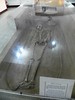
Excavated remains are now covered over, but the site remains susceptible to looting.
Note: Location provided is for the modern village.
See also Mohenjo-daro, another of the largest city-settlements of the Indus Valley Civilization.
Note: First ancient DNA from Indus Valley civilization links its people to modern South Asians (item from 2019). More on our page.
You may be viewing yesterday's version of this page. To see the most up to date information please register for a free account.
")
")
Do not use the above information on other web sites or publications without permission of the contributor.
Nearby Images from Flickr
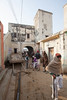
The above images may not be of the site on this page, but were taken nearby. They are loaded from Flickr so please click on them for image credits.
Click here to see more info for this site
Nearby sites
Click here to view sites on an interactive map of the areaKey: Red: member's photo, Blue: 3rd party photo, Yellow: other image, Green: no photo - please go there and take one, Grey: site destroyed
Download sites to:
KML (Google Earth)
GPX (GPS waypoints)
CSV (Garmin/Navman)
CSV (Excel)
To unlock full downloads you need to sign up as a Contributory Member. Otherwise downloads are limited to 50 sites.
Turn off the page maps and other distractions
Nearby sites listing. In the following links * = Image available
75.7km ESE 116° Farmana Harappan burial site Ancient Village or Settlement
134.6km SE 129° Qutab Minar Complex* Ancient Temple
278.8km SW 220° Sarasvati River Indus script Ancient Village or Settlement
295.0km NNE 33° Shri Bhima Kali Temple at Sarahan* Ancient Temple
329.7km NNE 17° Gauri Shankar* Ancient Temple
345.3km NNE 17° Manu Maharishi Temple* Ancient Temple
346.6km WNW 296° Harappa* Ancient Village or Settlement
346.8km NNE 17° Vashisht Temple Bowls* Ancient Temple
350.6km E 83° Lakhudiyar Rock Art Rock Art
430.4km S 186° Bundi* Ancient Village or Settlement
495.2km NNE 18° TaglangLa Pass Buddhist road temple* Ancient Temple
510.1km SSW 197° Chittorgarh fort* Hillfort
520.7km SSW 196° Udaipur* Ancient Temple
524.8km NNE 14° Markha valley Ladakh, Shorten's (Stupa's)* Ancient Temple
528.2km SE 126° Jajmau ka tila Ancient Village or Settlement
548.7km NNE 15° Nyerma Monastery* Ancient Temple
550.1km NNE 15° Thiksey (Kthiksey) Buddhist monestry in Ladak* Ancient Temple
551.2km NNE 15° Shey buddha engravings* Carving
552.7km NNE 14° Ladak N' India* Ancient Temple
552.9km SW 215° Korta, Pali Taluka* Ancient Temple
555.3km NNW 348° Burzahom Archaeological Site Standing Stones
556.8km N 10° Chilungtse altar stone Carving
557.1km NNE 12° Taroo petroglyphs Rock Art
557.8km N 10° Alchi Gompa* Ancient Temple
557.9km NNE 15° Saboo Rock* Rock Art
View more nearby sites and additional images


 We would like to know more about this location. Please feel free to add a brief description and any relevant information in your own language.
 Wir möchten mehr über diese Stätte erfahren. Bitte zögern Sie nicht, eine kurze Beschreibung und relevante Informationen in Deutsch hinzuzufügen.
 Nous aimerions en savoir encore un peu sur les lieux. S'il vous plaît n'hesitez pas à ajouter une courte description et tous les renseignements pertinents dans votre propre langue.
 Quisieramos informarnos un poco más de las lugares. No dude en añadir una breve descripción y otros datos relevantes en su propio idioma.