<< Image Pages >> Bhaja Cave Temples - Ancient Temple in India
Submitted by durhamnature on Monday, 08 April 2013 Page Views: 5664
Multi-periodSite Name: Bhaja Cave TemplesCountry: India
NOTE: This site is 59.217 km away from the location you searched for.
Type: Ancient Temple
Nearest Town: Lonavala Nearest Village: Karli
Latitude: 18.727778N Longitude: 73.481944E
Condition:
| 5 | Perfect |
| 4 | Almost Perfect |
| 3 | Reasonable but with some damage |
| 2 | Ruined but still recognisable as an ancient site |
| 1 | Pretty much destroyed, possibly visible as crop marks |
| 0 | No data. |
| -1 | Completely destroyed |
| 5 | Superb |
| 4 | Good |
| 3 | Ordinary |
| 2 | Not Good |
| 1 | Awful |
| 0 | No data. |
| 5 | Can be driven to, probably with disabled access |
| 4 | Short walk on a footpath |
| 3 | Requiring a bit more of a walk |
| 2 | A long walk |
| 1 | In the middle of nowhere, a nightmare to find |
| 0 | No data. |
| 5 | co-ordinates taken by GPS or official recorded co-ordinates |
| 4 | co-ordinates scaled from a detailed map |
| 3 | co-ordinates scaled from a bad map |
| 2 | co-ordinates of the nearest village |
| 1 | co-ordinates of the nearest town |
| 0 | no data |
Internal Links:
External Links:
")
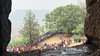
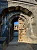
22 Buddhist cave temples in Maharashtra, close to the Karla Cave Temples. The main period of their creation was about 200 years BCE.
You may be viewing yesterday's version of this page. To see the most up to date information please register for a free account.
")
")
")
")
Do not use the above information on other web sites or publications without permission of the contributor.
Nearby Images from Flickr
The above images may not be of the site on this page, but were taken nearby. They are loaded from Flickr so please click on them for image credits.
Click here to see more info for this site
Nearby sites
Click here to view sites on an interactive map of the areaKey: Red: member's photo, Blue: 3rd party photo, Yellow: other image, Green: no photo - please go there and take one, Grey: site destroyed
Download sites to:
KML (Google Earth)
GPX (GPS waypoints)
CSV (Garmin/Navman)
CSV (Excel)
To unlock full downloads you need to sign up as a Contributory Member. Otherwise downloads are limited to 50 sites.
Turn off the page maps and other distractions
Nearby sites listing. In the following links * = Image available
5.8km ENE 67° Bedse Cave Temples* Ancient Temple
6.3km NNW 349° Karla caves* Rock Art
44.7km ESE 120° Pataleshwar cave temple * Ancient Temple
63.6km WNW 294° Elephanta Cave Temples* Ancient Temple
78.1km NW 305° Mahakali Caves Ancient Temple
80.1km NW 305° Jogeshwari Caves Ancient Temple
80.8km NW 311° Kanheri Cave Temples* Ancient Temple
84.5km NW 311° Mandapeshwar Caves Ancient Temple
133.7km N 2° Trimbakeshwar Temple* Ancient Temple
133.8km N 2° Kushavarta Teerth* Ancient Temple
137.6km NNE 12° Pandu Lena* Ancient Temple
145.9km NNE 13° Nashik- Kumbh Mela city* Ancient Temple
228.3km NE 51° Grishneshwar Jyotirlinga Temple* Ancient Temple
229.4km NE 50° Ellora cave temples* Ancient Temple
233.1km NE 55° Aurangabad Caves* Ancient Temple
308.5km NE 49° Ajanta Caves* Cave or Rock Shelter
384.3km SE 142° Kutkankeri* Rock Art
387.5km SE 142° Sri Mahakutta temple* Ancient Temple
389.0km SE 142° Sidlaphadi* Cave or Rock Shelter
390.2km SE 143° Badami Cave temple* Ancient Temple
394.3km SE 139° Aihole Cave Temples* Ancient Temple
394.9km SE 139° Ayawal* Burial Chamber or Dolmen
395.0km SE 141° Bachangudda* Burial Chamber or Dolmen
401.9km NW 307° Somnath Jyotirlinga temple* Ancient Temple
422.9km NNE 19° Bagh Cave Temples* Ancient Temple
View more nearby sites and additional images


 We would like to know more about this location. Please feel free to add a brief description and any relevant information in your own language.
 Wir möchten mehr über diese Stätte erfahren. Bitte zögern Sie nicht, eine kurze Beschreibung und relevante Informationen in Deutsch hinzuzufügen.
 Nous aimerions en savoir encore un peu sur les lieux. S'il vous plaît n'hesitez pas à ajouter une courte description et tous les renseignements pertinents dans votre propre langue.
 Quisieramos informarnos un poco más de las lugares. No dude en añadir una breve descripción y otros datos relevantes en su propio idioma.