<< Text Pages >> Abuja Cup Mark Stone - Rock Art in Nigeria
Submitted by KaiHofmann on Tuesday, 24 September 2013 Page Views: 5085
Rock ArtSite Name: Abuja Cup Mark StoneCountry: Nigeria
NOTE: This site is 492.84 km away from the location you searched for.
Type: Rock Art
Nearest Town: Abuja
Latitude: 9.188432N Longitude: 7.412254E
Condition:
| 5 | Perfect |
| 4 | Almost Perfect |
| 3 | Reasonable but with some damage |
| 2 | Ruined but still recognisable as an ancient site |
| 1 | Pretty much destroyed, possibly visible as crop marks |
| 0 | No data. |
| -1 | Completely destroyed |
| 5 | Superb |
| 4 | Good |
| 3 | Ordinary |
| 2 | Not Good |
| 1 | Awful |
| 0 | No data. |
| 5 | Can be driven to, probably with disabled access |
| 4 | Short walk on a footpath |
| 3 | Requiring a bit more of a walk |
| 2 | A long walk |
| 1 | In the middle of nowhere, a nightmare to find |
| 0 | No data. |
| 5 | co-ordinates taken by GPS or official recorded co-ordinates |
| 4 | co-ordinates scaled from a detailed map |
| 3 | co-ordinates scaled from a bad map |
| 2 | co-ordinates of the nearest village |
| 1 | co-ordinates of the nearest town |
| 0 | no data |
Be the first person to rate this site - see the 'Contribute!' box in the right hand menu.
Internal Links:
External Links:
Rock Art in Nigeria
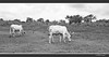
Cup marked stone on a hill above Lower Usuma lake.
You may be viewing yesterday's version of this page. To see the most up to date information please register for a free account.
Do not use the above information on other web sites or publications without permission of the contributor.
Nearby Images from Flickr
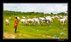
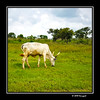
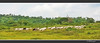
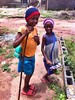
The above images may not be of the site on this page, but were taken nearby. They are loaded from Flickr so please click on them for image credits.
Click here to see more info for this site
Nearby sites
Click here to view sites on an interactive map of the areaKey: Red: member's photo, Blue: 3rd party photo, Yellow: other image, Green: no photo - please go there and take one, Grey: site destroyed
Download sites to:
KML (Google Earth)
GPX (GPS waypoints)
CSV (Garmin/Navman)
CSV (Excel)
To unlock full downloads you need to sign up as a Contributory Member. Otherwise downloads are limited to 50 sites.
Turn off the page maps and other distractions
Nearby sites listing. In the following links * = Image available
11.9km S 191° Jabi Cup Mark Stone Rock Art
32.0km SSE 163° Waru Cup Mark Stone Rock Art
73.2km ENE 62° Taruga* Ancient Village or Settlement
374.3km SSE 161° Ikom Monoliths* Standing Stones
857.8km N 10° Gobero Barrow Cemetery
903.4km NNE 17° Gobero Barrow Cemetery
1012.2km N 2° Air Giraffe Rock Art Rock Art
1099.6km NNE 15° Adrar Madet (Massif) Stone Circle Stone Circle
1261.1km NNW 332° Adrar des Ifoghas petroglyphs Rock Art
1310.5km SW 219° Pictish stone to be unceremoniously uprooted to museum NOT SET
1310.5km SW 219° 6000 year old settlement discovered in NW of Ireland NOT SET
1310.5km SW 219° County Guides No. 1 - Essex NOT SET
1310.5km SW 219° Lords and Ladies by Terry Pratchett at the Rollrights NOT SET
1310.5km SW 219° Crowders Mountain stones Natural Stone / Erratic / Other Natural Feature
1310.5km SW 219° Stone Circle reveals ancient secrets of rising and setting sun NOT SET
1310.5km SW 219° The Ringlemere Cup NOT SET
1310.5km SW 219° 'Sounds of the Stone Age', or Prehistoric Acoustics NOT SET
1310.5km SW 219° Scientists Study Bronze Age Drugs NOT SET
1310.5km SW 219° Coleraine to exploit stone age history NOT SET
1310.5km SW 219° Sutton Common Iron Age site in South Yorkshire NOT SET
1310.5km SW 219° Irish Government buy Poulnabrone Dolmen Burial Chamber or Dolmen
1310.5km SW 219° Prehistoric Music - BBC Radio 4 Frontiers NOT SET
1310.5km SW 219° Winter Solstice Maeshowe Webcam NOT SET
1310.5km SW 219° Ancient Stones around Bristol Natural Stone / Erratic / Other Natural Feature
1310.5km SW 219° Richard Rudgley in forthcoming TV series and conference NOT SET
View more nearby sites and additional images

")
 We would like to know more about this location. Please feel free to add a brief description and any relevant information in your own language.
 Wir möchten mehr über diese Stätte erfahren. Bitte zögern Sie nicht, eine kurze Beschreibung und relevante Informationen in Deutsch hinzuzufügen.
 Nous aimerions en savoir encore un peu sur les lieux. S'il vous plaît n'hesitez pas à ajouter une courte description et tous les renseignements pertinents dans votre propre langue.
 Quisieramos informarnos un poco más de las lugares. No dude en añadir una breve descripción y otros datos relevantes en su propio idioma.