<< Our Photo Pages >> Isimila - Ancient Village or Settlement in Tanzania
Submitted by bat400 on Tuesday, 17 May 2016 Page Views: 17058
Neolithic and Bronze AgeSite Name: Isimila Alternative Name: Isimila Stone Age SiteCountry: Tanzania
NOTE: This site is 269.5 km away from the location you searched for.
Type: Ancient Village or Settlement
Nearest Town: Iringa Nearest Village: Isimila
Latitude: 7.85272S Longitude: 35.630990E
Condition:
| 5 | Perfect |
| 4 | Almost Perfect |
| 3 | Reasonable but with some damage |
| 2 | Ruined but still recognisable as an ancient site |
| 1 | Pretty much destroyed, possibly visible as crop marks |
| 0 | No data. |
| -1 | Completely destroyed |
| 5 | Superb |
| 4 | Good |
| 3 | Ordinary |
| 2 | Not Good |
| 1 | Awful |
| 0 | No data. |
| 5 | Can be driven to, probably with disabled access |
| 4 | Short walk on a footpath |
| 3 | Requiring a bit more of a walk |
| 2 | A long walk |
| 1 | In the middle of nowhere, a nightmare to find |
| 0 | No data. |
| 5 | co-ordinates taken by GPS or official recorded co-ordinates |
| 4 | co-ordinates scaled from a detailed map |
| 3 | co-ordinates scaled from a bad map |
| 2 | co-ordinates of the nearest village |
| 1 | co-ordinates of the nearest town |
| 0 | no data |
Internal Links:
External Links:
")
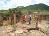
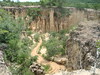
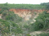
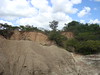
The main pillar area is accessed via a walk down into a steep valley (about one hour round-trip), for which you’ll need a guide (Tsh10,000 per group). Visits are best in the morning or late afternoon, before the sun gets too high.
The site lies about 15 km to the south west of Isimila town. The location given is an approximation based on this.
More details at Lonely Planet
You may be viewing yesterday's version of this page. To see the most up to date information please register for a free account.
")
")
")
Do not use the above information on other web sites or publications without permission of the contributor.
Nearby Images from Flickr

The above images may not be of the site on this page, but were taken nearby. They are loaded from Flickr so please click on them for image credits.
Click here to see more info for this site
Nearby sites
Click here to view sites on an interactive map of the areaKey: Red: member's photo, Blue: 3rd party photo, Yellow: other image, Green: no photo - please go there and take one, Grey: site destroyed
Download sites to:
KML (Google Earth)
GPX (GPS waypoints)
CSV (Garmin/Navman)
CSV (Excel)
To unlock full downloads you need to sign up as a Contributory Member. Otherwise downloads are limited to 50 sites.
Turn off the page maps and other distractions
Nearby sites listing. In the following links * = Image available
185.0km N 5° Dodoma Stones* Natural Stone / Erratic / Other Natural Feature
547.7km WSW 241° Mwela rock paintings Rock Art
578.5km N 351° Gong Rock* Rock Art
731.4km SSW 192° Chongoni Rock Art Rock Art
842.0km NNW 347° Ukula Rock Paintings Rock Art
843.7km N 4° Hyrax Hill Ancient Village or Settlement
923.4km NNE 13° Lewa Rock Gongs Rock Art
979.7km N 355° Orchard Cave, Kenya* Cave or Rock Shelter
1019.0km N 350° Kakoro Rock art Rock Art
1056.1km N 349° Nyero Rockpaintings Rock Art
1101.8km N 3° Namoratunga Rock Engravings Rock Art
1139.6km N 3° Lokori Stone Pillars Standing Stone (Menhir)
1183.5km NNW 328° Matupi Cave Cave or Rock Shelter
1199.9km N 2° Lothagam Pillar site Standing Stones
1235.2km WSW 247° Nyambwezu Rock Shelter Rock Art
1254.0km N 1° Kalokol stone pillars* Standing Stones
1411.6km SW 225° Sikaunda petroglyphs Rock Art
1470.7km SSW 200° Great Zimbabwe* Ancient Village or Settlement
1599.7km N 10° Tutu Fela* Sculptured Stone
1600.5km SSW 208° World's View Matobo National Park* Natural Stone / Erratic / Other Natural Feature
1606.3km SSW 208° Inanke Cave Cave or Rock Shelter
1607.1km SSW 208° Bambata Cave* Cave or Rock Shelter
1739.1km SSW 202° Machete I Rock Art
1757.2km ESE 120° Nosy Mangabe Graves Rock Cut Tomb
1807.1km SW 217° Makgadikgadi* Ancient Village or Settlement
View more nearby sites and additional images


 We would like to know more about this location. Please feel free to add a brief description and any relevant information in your own language.
 Wir möchten mehr über diese Stätte erfahren. Bitte zögern Sie nicht, eine kurze Beschreibung und relevante Informationen in Deutsch hinzuzufügen.
 Nous aimerions en savoir encore un peu sur les lieux. S'il vous plaît n'hesitez pas à ajouter une courte description et tous les renseignements pertinents dans votre propre langue.
 Quisieramos informarnos un poco más de las lugares. No dude en añadir una breve descripción y otros datos relevantes en su propio idioma.