<< Our Photo Pages >> Esperance Stonehenge - Modern Stone Circle etc in Australia
Submitted by Andy B on Monday, 19 September 2011 Page Views: 13450
Modern SitesSite Name: Esperance Stonehenge Alternative Name: 'Stonehenge Down Under'Country: Australia Type: Modern Stone Circle etc
Nearest Town: Esperance
Latitude: 33.7879S Longitude: 122.029600E
Condition:
| 5 | Perfect |
| 4 | Almost Perfect |
| 3 | Reasonable but with some damage |
| 2 | Ruined but still recognisable as an ancient site |
| 1 | Pretty much destroyed, possibly visible as crop marks |
| 0 | No data. |
| -1 | Completely destroyed |
| 5 | Superb |
| 4 | Good |
| 3 | Ordinary |
| 2 | Not Good |
| 1 | Awful |
| 0 | No data. |
| 5 | Can be driven to, probably with disabled access |
| 4 | Short walk on a footpath |
| 3 | Requiring a bit more of a walk |
| 2 | A long walk |
| 1 | In the middle of nowhere, a nightmare to find |
| 0 | No data. |
| 5 | co-ordinates taken by GPS or official recorded co-ordinates |
| 4 | co-ordinates scaled from a detailed map |
| 3 | co-ordinates scaled from a bad map |
| 2 | co-ordinates of the nearest village |
| 1 | co-ordinates of the nearest town |
| 0 | no data |
Internal Links:
External Links:
I have visited· I would like to visit
TheCaptain has visited here
")
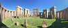
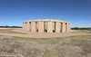
Esperance Stonehenge is currently under construction on the South Coast of Western Australia. While there are thought to be 66 large, permanent replicas of Stonehenge throughout the world, the Esperance project is believed to be the only life size stone one.
Esperance Stonehenge is close to being completed with the outer lintels the only stones left to be placed. All of the ten central stones have been erected and lintels placed on all of them. The 19 blue stones and the alter stones have also being placed, which has completed the inner circle. The grass has been laid within the central stones with the grass in the outer circle to be laid when the outer lintels are placed. We are currently open for viewing whilst under construction for $5 per adult. We currently have no eftpos facilities available.
The tourists that have been out to see Esperance Stonehenge have been astounded about the size and magnitude of the build. Many have said they will be back to see the finished product.
Link to official web site: http://www.esperancestonehenge.com.au
The story of the construction: The shire council in Esperance, 460 miles south-west of Perth, has approved plans for the A$1.2m (£722,749) project, which it hopes will generate much-needed tourist revenue for the small coastal community – its only attraction at the moment is small piece of the US Skylab which fell onto a nearby farm in 1979.
"Stonehenge Down Under" is being spearheaded by the local Rotary club, which wants to build the structure from local pink granite on a council-owned site overlooking Twilight Beach, just outside the town. [makes a change from Australia's Stonehenge I suppose - MegP Ed]
Kim Beale, a spokesman for the Esperance Rotary Club, said the Australian version would be a faithful reproduction of the original Neolithic structure in Wiltshire and will consist of 100 stones, each weighing up to 45 tons.
"Obviously some people may wonder why you'd build Stonehenge at Esperance, but the stone is already here and I think it's a good opportunity. I reckon it's quite fascinating," he said.
Although local tourism operators have thrown their weight behind the prehistoric theme park, other townspeople remain sceptical – an earlier Stonehenge proposal ran into financial difficulties. Rotary, however, is confident that it can raise the necessary funds to complete the new project with giant cut stones donated by a local quarry. Work on Stonehenge Mk 2 is due to begin shortly.
Source: Telegraph, spotted by Runemage
Note: Photos of the pink granite Stonehenge in southern Australia which is nearing completion
You may be viewing yesterday's version of this page. To see the most up to date information please register for a free account.
")
")
")
Do not use the above information on other web sites or publications without permission of the contributor.
Nearby Images from Flickr


The above images may not be of the site on this page, but were taken nearby. They are loaded from Flickr so please click on them for image credits.
Click here to see more info for this site
Nearby sites
Click here to view sites on an interactive map of the areaKey: Red: member's photo, Blue: 3rd party photo, Yellow: other image, Green: no photo - please go there and take one, Grey: site destroyed
Download sites to:
KML (Google Earth)
GPX (GPS waypoints)
CSV (Garmin/Navman)
CSV (Excel)
To unlock full downloads you need to sign up as a Contributory Member. Otherwise downloads are limited to 50 sites.
Turn off the page maps and other distractions
Nearby sites listing. In the following links * = Image available
327.8km WNW 296° Wave Rock* Natural Stone / Erratic / Other Natural Feature
329.5km WNW 299° Mulka's Cave* Rock Art
611.2km WNW 288° Western Australia Museum* Museum
646.6km W 265° Mammoth Cave Margaret River* Cave or Rock Shelter
736.9km WNW 297° The Pinnacles* Natural Stone / Erratic / Other Natural Feature
782.0km ENE 72° Koonalda Cave Cave or Rock Shelter
1236.4km NNW 346° Hope Downs Cave or Rock Shelter
1279.4km NE 45° Ayers Rock* Rock Art
1301.2km NNW 340° Pibara Petroglyphs* Rock Art
1433.9km NNW 343° Nunyerry Creek* Rock Art
1486.5km NE 49° Henbury Meteorite Craters* Natural Stone / Erratic / Other Natural Feature
1552.6km NNW 339° Burrup Peninsula* Rock Art
1562.0km E 84° Warratyi* Cave or Rock Shelter
1584.1km E 85° Nala Stone Men* Modern Stone Circle etc
1722.5km NNE 21° Wolf Creek Crater Natural Stone / Erratic / Other Natural Feature
1746.2km ESE 110° Mount Gambier* Ancient Mine, Quarry or other Industry
1900.6km NE 42° Devil's Marbles* Natural Stone / Erratic / Other Natural Feature
1943.1km E 96° Mungo, Australia* Ancient Village or Settlement
2062.0km ESE 110° Geelong Stone Setting Standing Stones
2068.0km ESE 109° Wurdi Youang* Stone Row / Alignment
2125.4km NNE 14° Drysdale River National Park Rock Art
2205.9km E 89° 25-3-0057 Stone Row / Alignment
2220.9km NNE 13° Kalumburu Cave or Rock Shelter
2324.9km E 89° 17-1-0006 Stone Row / Alignment
2404.5km ESE 122° Jordan River Levee Ancient Village or Settlement
View more nearby sites and additional images


 We would like to know more about this location. Please feel free to add a brief description and any relevant information in your own language.
 Wir möchten mehr über diese Stätte erfahren. Bitte zögern Sie nicht, eine kurze Beschreibung und relevante Informationen in Deutsch hinzuzufügen.
 Nous aimerions en savoir encore un peu sur les lieux. S'il vous plaît n'hesitez pas à ajouter une courte description et tous les renseignements pertinents dans votre propre langue.
 Quisieramos informarnos un poco más de las lugares. No dude en añadir una breve descripción y otros datos relevantes en su propio idioma.