<< Other Photo Pages >> Avencal 1 - Rock Art in Brazil
Submitted by bat400 on Friday, 10 April 2015 Page Views: 6613
Rock ArtSite Name: Avencal 1 Alternative Name: Inscricoes RupestresCountry: Brazil
NOTE: This site is 260.144 km away from the location you searched for.
Type: Rock Art
Nearest Town: Urubici
Latitude: 28.028S Longitude: 49.612W
Condition:
| 5 | Perfect |
| 4 | Almost Perfect |
| 3 | Reasonable but with some damage |
| 2 | Ruined but still recognisable as an ancient site |
| 1 | Pretty much destroyed, possibly visible as crop marks |
| 0 | No data. |
| -1 | Completely destroyed |
| 5 | Superb |
| 4 | Good |
| 3 | Ordinary |
| 2 | Not Good |
| 1 | Awful |
| 0 | No data. |
| 5 | Can be driven to, probably with disabled access |
| 4 | Short walk on a footpath |
| 3 | Requiring a bit more of a walk |
| 2 | A long walk |
| 1 | In the middle of nowhere, a nightmare to find |
| 0 | No data. |
| 5 | co-ordinates taken by GPS or official recorded co-ordinates |
| 4 | co-ordinates scaled from a detailed map |
| 3 | co-ordinates scaled from a bad map |
| 2 | co-ordinates of the nearest village |
| 1 | co-ordinates of the nearest town |
| 0 | no data |
Internal Links:
External Links:
")
Originally documented in the 1960's, some researchers (Da Silva, 2001) hypothosize that the art shows continuity between modern indigenous Jê peoples and the creators of this rock art 4000 years ago by parallels between body paint, archaeological ceramic decoration and rock art motifs.
Some figures have black pigment in some areas (which may not be orginal.)
The figures appear to be on a cliff face within sight of the much more famous Avencal waterfall. From tourist websites it appears that the cliff face immediately fronts on a pass with a modern road. There is signage for the location itself and a roadside parking area, but no infomation on the rockart itself.
Note: Recording Pre-Columbian Engravings in Brazil using Polynomial Texture Mapping. See comment.
You may be viewing yesterday's version of this page. To see the most up to date information please register for a free account.
Do not use the above information on other web sites or publications without permission of the contributor.
Nearby Images from Flickr
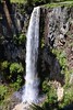
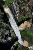
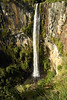
The above images may not be of the site on this page, but were taken nearby. They are loaded from Flickr so please click on them for image credits.
Click here to see more info for this site
Nearby sites
Click here to view sites on an interactive map of the areaKey: Red: member's photo, Blue: 3rd party photo, Yellow: other image, Green: no photo - please go there and take one, Grey: site destroyed
Download sites to:
KML (Google Earth)
GPX (GPS waypoints)
CSV (Garmin/Navman)
CSV (Excel)
To unlock full downloads you need to sign up as a Contributory Member. Otherwise downloads are limited to 50 sites.
Turn off the page maps and other distractions
Nearby sites listing. In the following links * = Image available
86.5km SE 135° Jabuticabeira II Barrow Cemetery
904.9km SW 226° Localidad Rupestre de Chamangá Rock Art
1055.0km NNW 329° Taboco* Rock Art
1098.5km SW 224° La Plata Museum Museum
1106.7km NNE 32° Lapa do Santo Rock shelter* Cave or Rock Shelter
1533.9km NNE 22° Peruaçu* Rock Art
1591.5km W 271° Tafi del Valle* Sculptured Stone
1601.3km NNW 330° Santa Elena (Brazil)* Rock Art
1612.9km W 279° MAAM* Museum
1618.1km W 272° Museo Pachamama* Museum
1630.8km W 271° Fuerte Quemado* Ancient Village or Settlement
1631.8km W 272° Los Quilmes* Ancient Village or Settlement
1650.1km WNW 284° La Huerta Ancient Village or Settlement
1654.6km WNW 284° Pucará de Tilcara* Ancient Village or Settlement
1654.9km WNW 284° Pucará del Angosto de Perchel Hillfort
1655.6km WNW 284° Pucará de Campo Morado Hillfort
1656.9km WNW 285° Pucará de Yacoraite Hillfort
1657.1km WNW 284° Pucará de Juella Hillfort
1661.4km WNW 286° Coctaca Ancient Village or Settlement
1661.6km WNW 285° Los Armarillos Ancient Village or Settlement
1664.1km WNW 285° Pucará de Peñas Blancas Hillfort
1673.0km W 279° Potrero de Payogasta* Ancient Village or Settlement
1675.8km W 277° Archaeological Museum Pío Pablo Díaz* Museum
1676.6km W 277° Mariscal Ancient Village or Settlement
1679.6km W 277° Bogatta Ancient Village or Settlement
View more nearby sites and additional images


 We would like to know more about this location. Please feel free to add a brief description and any relevant information in your own language.
 Wir möchten mehr über diese Stätte erfahren. Bitte zögern Sie nicht, eine kurze Beschreibung und relevante Informationen in Deutsch hinzuzufügen.
 Nous aimerions en savoir encore un peu sur les lieux. S'il vous plaît n'hesitez pas à ajouter une courte description et tous les renseignements pertinents dans votre propre langue.
 Quisieramos informarnos un poco más de las lugares. No dude en añadir una breve descripción y otros datos relevantes en su propio idioma.