<< Our Photo Pages >> Cerro Pintados - Hill Figure or Geoglyph in Chile
Submitted by SolarMegalith on Monday, 18 August 2008 Page Views: 7050
Multi-periodSite Name: Cerro PintadosCountry: Chile
NOTE: This site is 126.75 km away from the location you searched for.
Type: Hill Figure or Geoglyph
Nearest Town: Iquique Nearest Village: Pintados
Latitude: 20.6262S Longitude: 69.6645W
Condition:
| 5 | Perfect |
| 4 | Almost Perfect |
| 3 | Reasonable but with some damage |
| 2 | Ruined but still recognisable as an ancient site |
| 1 | Pretty much destroyed, possibly visible as crop marks |
| 0 | No data. |
| -1 | Completely destroyed |
| 5 | Superb |
| 4 | Good |
| 3 | Ordinary |
| 2 | Not Good |
| 1 | Awful |
| 0 | No data. |
| 5 | Can be driven to, probably with disabled access |
| 4 | Short walk on a footpath |
| 3 | Requiring a bit more of a walk |
| 2 | A long walk |
| 1 | In the middle of nowhere, a nightmare to find |
| 0 | No data. |
| 5 | co-ordinates taken by GPS or official recorded co-ordinates |
| 4 | co-ordinates scaled from a detailed map |
| 3 | co-ordinates scaled from a bad map |
| 2 | co-ordinates of the nearest village |
| 1 | co-ordinates of the nearest town |
| 0 | no data |
Internal Links:
External Links:
I have visited· I would like to visit
SolarMegalith visited on 1st Mar 2007 - their rating: Cond: 4 Amb: 4 Access: 5
")
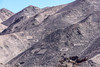
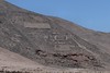
One of the largest groups of geoglyphs in South America. According to some sources there are approximately 300 geoglyphs here ! They were made before 1000 year CE. The site is located on the area of Papma del Tamarugal reserve.
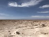
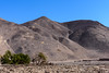
This area has a fantastic ambience - simillar to Toro Muerto one, the whole area looks like a surface of the moon ...
The Googlemaps link above will take you to some photographs of the geoglyphs. Navigate to see geometric figures, animals, and human figures.
You may be viewing yesterday's version of this page. To see the most up to date information please register for a free account.
")
")
Do not use the above information on other web sites or publications without permission of the contributor.
Nearby Images from Flickr

The above images may not be of the site on this page, but were taken nearby. They are loaded from Flickr so please click on them for image credits.
Click here to see more info for this site
Nearby sites
Click here to view sites on an interactive map of the areaKey: Red: member's photo, Blue: 3rd party photo, Yellow: other image, Green: no photo - please go there and take one, Grey: site destroyed
Download sites to:
KML (Google Earth)
GPX (GPS waypoints)
CSV (Garmin/Navman)
CSV (Excel)
To unlock full downloads you need to sign up as a Contributory Member. Otherwise downloads are limited to 50 sites.
Turn off the page maps and other distractions
Nearby sites listing. In the following links * = Image available
75.4km N 2° Atacama Giant* Hill Figure or Geoglyph
81.5km NNE 12° Tarapacá geoglyphs Hill Figure or Geoglyph
124.0km NNW 345° Tiliviche Geoglyphs* Hill Figure or Geoglyph
162.1km NNW 347° Chiza Geoglyphs* Hill Figure or Geoglyph
182.0km SSE 164° Chug Chug Geoglyphs* Hill Figure or Geoglyph
235.6km NNW 348° Azapa Valley Geoglyphs* Hill Figure or Geoglyph
240.7km NNW 347° San Miguel de Azapa Archaeological Museum* Museum
240.8km NNW 346° Cerro Sagrado Geoglyphs Hill Figure or Geoglyph
242.9km NNW 345° La Tropilla Geoglyphs* Hill Figure or Geoglyph
252.0km NNW 346° Lluta Valley Geoglyphs* Hill Figure or Geoglyph
271.6km SSE 147° Petroglifos Yerbas Buenas* Rock Art
293.7km SSE 150° Pucara de Quitor* Stone Fort or Dun
295.2km SSE 149° R. P. Gustavo Le Paige Archaeological Museum* Museum
298.9km SSE 151° Tulor Ancient Village or Settlement
374.1km NNW 333° Museo Chiribaya Museum
374.4km NNW 333° Chiribaya Alta Ancient Village or Settlement
410.5km NNW 342° Cerro Baul Ancient Village or Settlement
423.8km ENE 75° Cerro Rico* Ancient Mine, Quarry or other Industry
424.3km ENE 73° Tarapaya* Natural Stone / Erratic / Other Natural Feature
450.7km N 4° Cuncaicha Natural Stone / Erratic / Other Natural Feature
463.7km NNE 13° Pumapunku* Ancient Temple
464.5km NNE 13° Tiwanaku - Akapana Pyramid* Pyramid / Mastaba
464.6km NNE 13° Tiwanaku* Ancient Village or Settlement
467.5km SSE 166° Llullaillaco Vault Chambered Tomb
476.2km SE 130° Barrancas Rock Art
View more nearby sites and additional images


 We would like to know more about this location. Please feel free to add a brief description and any relevant information in your own language.
 Wir möchten mehr über diese Stätte erfahren. Bitte zögern Sie nicht, eine kurze Beschreibung und relevante Informationen in Deutsch hinzuzufügen.
 Nous aimerions en savoir encore un peu sur les lieux. S'il vous plaît n'hesitez pas à ajouter une courte description et tous les renseignements pertinents dans votre propre langue.
 Quisieramos informarnos un poco más de las lugares. No dude en añadir una breve descripción y otros datos relevantes en su propio idioma.