<< Text Pages >> Sucre Museum of Anthropology - Museum in Bolivia
Submitted by davidmorgan on Thursday, 01 March 2012 Page Views: 3886
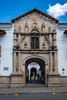
MuseumsSite Name: Sucre Museum of Anthropology Alternative Name: Museo CharcasCountry: Bolivia
NOTE: This site is 160.902 km away from the location you searched for.
Type: Museum
Nearest Town: Sucre
Latitude: 19.050212S Longitude: 65.259156W
Condition:
| 5 | Perfect |
| 4 | Almost Perfect |
| 3 | Reasonable but with some damage |
| 2 | Ruined but still recognisable as an ancient site |
| 1 | Pretty much destroyed, possibly visible as crop marks |
| 0 | No data. |
| -1 | Completely destroyed |
| 5 | Superb |
| 4 | Good |
| 3 | Ordinary |
| 2 | Not Good |
| 1 | Awful |
| 0 | No data. |
| 5 | Can be driven to, probably with disabled access |
| 4 | Short walk on a footpath |
| 3 | Requiring a bit more of a walk |
| 2 | A long walk |
| 1 | In the middle of nowhere, a nightmare to find |
| 0 | No data. |
| 5 | co-ordinates taken by GPS or official recorded co-ordinates |
| 4 | co-ordinates scaled from a detailed map |
| 3 | co-ordinates scaled from a bad map |
| 2 | co-ordinates of the nearest village |
| 1 | co-ordinates of the nearest town |
| 0 | no data |
Internal Links:
External Links:
I have visited· I would like to visit
davidmorgan has visited here
The largest museum in Sucre, it contains some nice examples of Inca mummies and the famous elongated skulls.
More information here.
You may be viewing yesterday's version of this page. To see the most up to date information please register for a free account.
Do not use the above information on other web sites or publications without permission of the contributor.
Nearby Images from Flickr

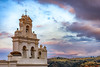

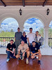

The above images may not be of the site on this page, but were taken nearby. They are loaded from Flickr so please click on them for image credits.
Click here to see more info for this site
Nearby sites
Click here to view sites on an interactive map of the areaKey: Red: member's photo, Blue: 3rd party photo, Yellow: other image, Green: no photo - please go there and take one, Grey: site destroyed
Download sites to:
KML (Google Earth)
GPX (GPS waypoints)
CSV (Garmin/Navman)
CSV (Excel)
To unlock full downloads you need to sign up as a Contributory Member. Otherwise downloads are limited to 50 sites.
Turn off the page maps and other distractions
Nearby sites listing. In the following links * = Image available
72.9km SW 230° Tarapaya* Natural Stone / Erratic / Other Natural Feature
81.5km SW 219° Cerro Rico* Ancient Mine, Quarry or other Industry
171.3km NE 53° Mairana Circular Pyramid Pyramid / Mastaba
180.0km ENE 58° El Fuerte de Samaipata Pyramid / Mastaba
455.3km WSW 257° Tarapacá geoglyphs Hill Figure or Geoglyph
455.5km NW 307° Tiwanaku - Akapana Pyramid* Pyramid / Mastaba
455.6km S 180° Coctaca Ancient Village or Settlement
455.7km NW 307° Tiwanaku* Ancient Village or Settlement
455.7km NW 307° Pumapunku* Ancient Temple
461.4km S 181° Pucará de Peñas Blancas Hillfort
469.2km WSW 257° Atacama Giant* Hill Figure or Geoglyph
479.4km S 181° Los Armarillos Ancient Village or Settlement
480.7km NW 309° Suriki Island* Ancient Mine, Quarry or other Industry
480.8km S 181° Pucará de Yacoraite Hillfort
484.7km S 190° Barrancas Rock Art
486.0km S 181° Pucará de Campo Morado Hillfort
492.1km S 181° La Huerta Ancient Village or Settlement
493.0km WSW 248° Cerro Pintados* Hill Figure or Geoglyph
493.7km S 181° Pucará del Angosto de Perchel Hillfort
496.8km S 182° Pucará de Juella Hillfort
497.3km W 263° Tiliviche Geoglyphs* Hill Figure or Geoglyph
499.3km W 267° Chiza Geoglyphs* Hill Figure or Geoglyph
504.7km S 182° Pucará de Tilcara* Ancient Village or Settlement
508.2km SW 217° Petroglifos Yerbas Buenas* Rock Art
515.0km WNW 302° Cuncaicha Natural Stone / Erratic / Other Natural Feature
View more nearby sites and additional images


 We would like to know more about this location. Please feel free to add a brief description and any relevant information in your own language.
 Wir möchten mehr über diese Stätte erfahren. Bitte zögern Sie nicht, eine kurze Beschreibung und relevante Informationen in Deutsch hinzuzufügen.
 Nous aimerions en savoir encore un peu sur les lieux. S'il vous plaît n'hesitez pas à ajouter une courte description et tous les renseignements pertinents dans votre propre langue.
 Quisieramos informarnos un poco más de las lugares. No dude en añadir una breve descripción y otros datos relevantes en su propio idioma.