<< Our Photo Pages >> Cerro Rico - Ancient Mine, Quarry or other Industry in Bolivia
Submitted by davidmorgan on Sunday, 17 June 2007 Page Views: 6435
Multi-periodSite Name: Cerro RicoCountry: Bolivia
NOTE: This site is 78.221 km away from the location you searched for.
Type: Ancient Mine, Quarry or other Industry
Nearest Town: Potosí
Latitude: 19.618823S Longitude: 65.749625W
Condition:
| 5 | Perfect |
| 4 | Almost Perfect |
| 3 | Reasonable but with some damage |
| 2 | Ruined but still recognisable as an ancient site |
| 1 | Pretty much destroyed, possibly visible as crop marks |
| 0 | No data. |
| -1 | Completely destroyed |
| 5 | Superb |
| 4 | Good |
| 3 | Ordinary |
| 2 | Not Good |
| 1 | Awful |
| 0 | No data. |
| 5 | Can be driven to, probably with disabled access |
| 4 | Short walk on a footpath |
| 3 | Requiring a bit more of a walk |
| 2 | A long walk |
| 1 | In the middle of nowhere, a nightmare to find |
| 0 | No data. |
| 5 | co-ordinates taken by GPS or official recorded co-ordinates |
| 4 | co-ordinates scaled from a detailed map |
| 3 | co-ordinates scaled from a bad map |
| 2 | co-ordinates of the nearest village |
| 1 | co-ordinates of the nearest town |
| 0 | no data |
Internal Links:
External Links:
I have visited· I would like to visit
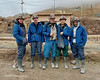
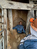
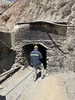
davidmorgan has visited here
")
You may be viewing yesterday's version of this page. To see the most up to date information please register for a free account.
")
")
")
Do not use the above information on other web sites or publications without permission of the contributor.
Nearby Images from Flickr

The above images may not be of the site on this page, but were taken nearby. They are loaded from Flickr so please click on them for image credits.
Click here to see more info for this site
Nearby sites
Click here to view sites on an interactive map of the areaKey: Red: member's photo, Blue: 3rd party photo, Yellow: other image, Green: no photo - please go there and take one, Grey: site destroyed
Download sites to:
KML (Google Earth)
GPX (GPS waypoints)
CSV (Garmin/Navman)
CSV (Excel)
To unlock full downloads you need to sign up as a Contributory Member. Otherwise downloads are limited to 50 sites.
Turn off the page maps and other distractions
Nearby sites listing. In the following links * = Image available
17.5km NNW 344° Tarapaya* Natural Stone / Erratic / Other Natural Feature
81.5km NE 39° Sucre Museum of Anthropology Museum
251.1km NE 49° Mairana Circular Pyramid Pyramid / Mastaba
258.6km NE 52° El Fuerte de Samaipata Pyramid / Mastaba
394.4km W 265° Tarapacá geoglyphs Hill Figure or Geoglyph
395.3km S 173° Coctaca Ancient Village or Settlement
400.4km S 174° Pucará de Peñas Blancas Hillfort
408.0km W 264° Atacama Giant* Hill Figure or Geoglyph
415.3km S 185° Barrancas Rock Art
417.7km S 175° Los Armarillos Ancient Village or Settlement
419.7km S 174° Pucará de Yacoraite Hillfort
423.8km WSW 254° Cerro Pintados* Hill Figure or Geoglyph
424.8km S 174° Pucará de Campo Morado Hillfort
426.7km SW 217° Petroglifos Yerbas Buenas* Rock Art
431.2km S 174° La Huerta Ancient Village or Settlement
432.2km S 175° Pucará del Angosto de Perchel Hillfort
434.9km S 175° Pucará de Juella Hillfort
442.0km W 270° Tiliviche Geoglyphs* Hill Figure or Geoglyph
442.7km S 175° Pucará de Tilcara* Ancient Village or Settlement
445.2km SW 214° R. P. Gustavo Le Paige Archaeological Museum* Museum
445.6km SW 215° Pucara de Quitor* Stone Fort or Dun
449.0km W 275° Chiza Geoglyphs* Hill Figure or Geoglyph
453.2km SW 214° Tulor Ancient Village or Settlement
457.0km SW 231° Chug Chug Geoglyphs* Hill Figure or Geoglyph
459.8km NW 317° Tiwanaku - Akapana Pyramid* Pyramid / Mastaba
View more nearby sites and additional images


 We would like to know more about this location. Please feel free to add a brief description and any relevant information in your own language.
 Wir möchten mehr über diese Stätte erfahren. Bitte zögern Sie nicht, eine kurze Beschreibung und relevante Informationen in Deutsch hinzuzufügen.
 Nous aimerions en savoir encore un peu sur les lieux. S'il vous plaît n'hesitez pas à ajouter une courte description et tous les renseignements pertinents dans votre propre langue.
 Quisieramos informarnos un poco más de las lugares. No dude en añadir una breve descripción y otros datos relevantes en su propio idioma.