<< Text Pages >> Makay Massif Paintings - Rock Art in Madagascar
Submitted by KaiHofmann on Sunday, 27 January 2019 Page Views: 7973
Rock ArtSite Name: Makay Massif PaintingsCountry: Madagascar
NOTE: This site is 318.356 km away from the location you searched for.
Type: Rock Art
Nearest Town: Mandabe Nearest Village: Maromiandra
Latitude: 21.339926S Longitude: 45.173694E
Condition:
| 5 | Perfect |
| 4 | Almost Perfect |
| 3 | Reasonable but with some damage |
| 2 | Ruined but still recognisable as an ancient site |
| 1 | Pretty much destroyed, possibly visible as crop marks |
| 0 | No data. |
| -1 | Completely destroyed |
| 5 | Superb |
| 4 | Good |
| 3 | Ordinary |
| 2 | Not Good |
| 1 | Awful |
| 0 | No data. |
| 5 | Can be driven to, probably with disabled access |
| 4 | Short walk on a footpath |
| 3 | Requiring a bit more of a walk |
| 2 | A long walk |
| 1 | In the middle of nowhere, a nightmare to find |
| 0 | No data. |
| 5 | co-ordinates taken by GPS or official recorded co-ordinates |
| 4 | co-ordinates scaled from a detailed map |
| 3 | co-ordinates scaled from a bad map |
| 2 | co-ordinates of the nearest village |
| 1 | co-ordinates of the nearest town |
| 0 | no data |
Internal Links:
External Links:
Several ancient and newer rock paintings, human burials in caves and cup marks respectively mortars were found by scientist in the canyons and on the hills of the Makay Massif in Madagascar.
The paintings are showing crosses, building like paintings, geometric shapes, animals like cattle and human beings such as shamans with an antler. The large island of Madagascar was populated around 200 CE until 300 BCE. Some of the paintings could be around 2000 years old. For more informations see:
This is a link in French
This is a link in English and French
You may be viewing yesterday's version of this page. To see the most up to date information please register for a free account.
Do not use the above information on other web sites or publications without permission of the contributor.
Nearby Images from Flickr
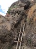
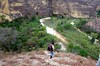


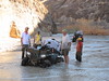
The above images may not be of the site on this page, but were taken nearby. They are loaded from Flickr so please click on them for image credits.
Click here to see more info for this site
Nearby sites
Click here to view sites on an interactive map of the areaKey: Red: member's photo, Blue: 3rd party photo, Yellow: other image, Green: no photo - please go there and take one, Grey: site destroyed
Download sites to:
KML (Google Earth)
GPX (GPS waypoints)
CSV (Garmin/Navman)
CSV (Excel)
To unlock full downloads you need to sign up as a Contributory Member. Otherwise downloads are limited to 50 sites.
Turn off the page maps and other distractions
Nearby sites listing. In the following links * = Image available
810.6km NE 37° Nosy Mangabe Graves Rock Cut Tomb
1393.3km WNW 302° Chongoni Rock Art Rock Art
1478.0km WSW 242° Border Cave* Cave or Rock Shelter
1484.4km W 272° Great Zimbabwe* Ancient Village or Settlement
1536.0km WSW 247° Lion Cavern Ngwenya Ancient Mine, Quarry or other Industry
1544.4km WSW 249° Bantu stone circles* Standing Stones
1642.5km W 264° Machete I Rock Art
1679.8km SW 234° Sibudu Cave* Cave or Rock Shelter
1732.2km W 270° Inanke Cave Cave or Rock Shelter
1732.2km W 270° World's View Matobo National Park* Natural Stone / Erratic / Other Natural Feature
1743.3km W 270° Bambata Cave* Cave or Rock Shelter
1758.0km WSW 258° Palala River Bluffs San Rock Paintings* Rock Art
1794.6km WSW 237° Kamberg rock art Rock Art
1798.4km WSW 251° African Window* Museum
1816.0km NW 324° Isimila* Ancient Village or Settlement
1823.3km WSW 236° Ikanti Shelter I Rock Art
1835.1km WSW 251° Malapa* Cave or Rock Shelter
1848.7km WSW 250° Sterkfontein* Cave or Rock Shelter
1936.5km NW 308° Mwela rock paintings Rock Art
1938.9km WSW 237° Lesob 5 Rock Art
1938.9km WSW 237° Lesob 4 Rock Art
1939.4km WSW 237° Lesob 3 Rock Art
1939.4km WSW 237° Lesob 2 Rock Art
1940.1km WSW 237° Lesob 1 Rock Art
1964.9km NNW 328° Dodoma Stones* Natural Stone / Erratic / Other Natural Feature
View more nearby sites and additional images


 We would like to know more about this location. Please feel free to add a brief description and any relevant information in your own language.
 Wir möchten mehr über diese Stätte erfahren. Bitte zögern Sie nicht, eine kurze Beschreibung und relevante Informationen in Deutsch hinzuzufügen.
 Nous aimerions en savoir encore un peu sur les lieux. S'il vous plaît n'hesitez pas à ajouter une courte description et tous les renseignements pertinents dans votre propre langue.
 Quisieramos informarnos un poco más de las lugares. No dude en añadir una breve descripción y otros datos relevantes en su propio idioma.