


Bryn Cader Faner
Submitted by celticmaiden55 on Wednesday, 30 October 2024 Page Views: 54739
Neolithic and Bronze AgeSite Name: Bryn Cader FanerCountry: Wales County: Gwynedd Type: Ring Cairn
Nearest Town: Porthmadog Nearest Village: Talsarnau
Map Ref: SH64793529 Landranger Map Number: 124
Latitude: 52.897997N Longitude: 4.011505W
Condition:
| 5 | Perfect |
| 4 | Almost Perfect |
| 3 | Reasonable but with some damage |
| 2 | Ruined but still recognisable as an ancient site |
| 1 | Pretty much destroyed, possibly visible as crop marks |
| 0 | No data. |
| -1 | Completely destroyed |
| 5 | Superb |
| 4 | Good |
| 3 | Ordinary |
| 2 | Not Good |
| 1 | Awful |
| 0 | No data. |
| 5 | Can be driven to, probably with disabled access |
| 4 | Short walk on a footpath |
| 3 | Requiring a bit more of a walk |
| 2 | A long walk |
| 1 | In the middle of nowhere, a nightmare to find |
| 0 | No data. |
| 5 | co-ordinates taken by GPS or official recorded co-ordinates |
| 4 | co-ordinates scaled from a detailed map |
| 3 | co-ordinates scaled from a bad map |
| 2 | co-ordinates of the nearest village |
| 1 | co-ordinates of the nearest town |
| 0 | no data |
In The Old Stones Book: p.239
Internal Links:


External Links:


I have visited· I would like to visit
hirnant tlcearth Humbucker Magaret1932 DocRivers eirrac5 Runemage muddysox DrewParsons SumDoood WindC MikeAttwell Orcinus 43559959 lichen Andy B would like to visit
drolaf visited on 9th Jun 2025 Walked over from below Bryn Bwbach, the valley is amazing. Took a ‘short cut’ at Coetty-maur up to the main path higher up at Y Gym. This path is a bit sploshy but not boggy. The weather was dire grey cold windy wet. I would have liked to stay longer but the wind was just grim.
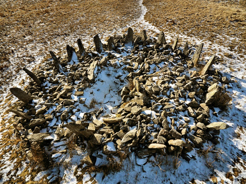
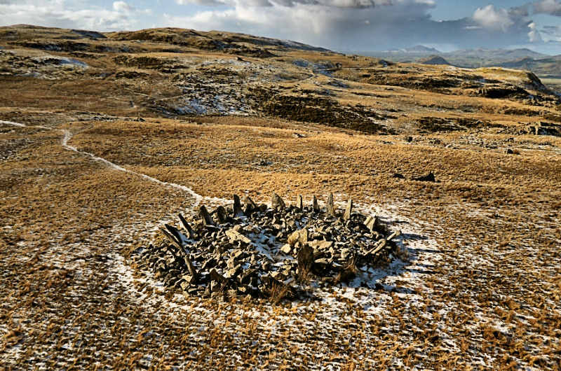
I counted 26 pointy stones, 2 were next to each other. Seeing it on the hillside is a welcome sight after a long trek.
Couplands visited on 16th Nov 2024
Northernchief visited on 23rd Sep 2023 Well worth the walk. The direct path, although wet, was easily passable.
w650marion visited on 18th Apr 2023 Path from Eisingrug the wettest I've seen in 30 years visiting. Waterproof boots, gaiters and bog prodders essential. Return journey was via the hut circle settlements on the slopes above the path. Much easier!
Catrinm visited on 18th Apr 2019 Worth the trek, great views
SteCymru14 visited on 29th Dec 2016
SteCymru14 visited on 29th Dec 2016 https://stecymru14.wordpress.com/2016/12/30/per-mare-per-terram-evorsio/
morphoto visited on 1st Sep 2013 We followed the directions of flyerphil, driving up the track that parallels the Maes-y-Neuadd Hotel on the south side. Be sure to bare to the right as you go up. Once at the car park, leave a donation and follow the trail that is on the south side. It will cross over the Taithardudwy Way Trail. Take that trail, it is much easier and less boggy than flyerphil's path to the lake and then around the lake. It was a chilly, spooky, foggy, rainy day and we spied the crown of thorns topping a hill shrouded in the fog in the distance. It was like being in a mystical world, far away and long ago. The site is much altered, but still stunning. Well worth the hunt.
crystalskull84 visited on 4th May 2011 Superb location! One of the most rewarding finds.
celticmaiden55 w650marion Bladup PAB TimPrevett TheCaptain have visited here
Log in or create a free account to see how our visitors rate this site for condition, ambience and access, and to record your own visits.

Access: 7km of track and trail, some of it through wet and boggy terrain, make this a challenge for the novice circle-hunter. Success is well worth the effort.
Page originally by Tom Bullock
Note: Youtube video producers CoralJackz have made an informative 20 minute documentary of their visit, exploring the history and archaeology Bryn Cader Faner: The Finest Ring Cairn In Wales. The link is the comments
You may be viewing yesterday's version of this page. To see the most up to date information please register for a free account.






These are just the first 25 photos of Bryn Cader Faner. If you log in with a free user account you will be able to see our entire collection.
Do not use the above information on other web sites or publications without permission of the contributor.
Click here to see more info for this site
All Nearby sites
 Click here to view sites on an interactive OS map
Download sites to:
KML (Google Earth)
GPX (GPS waypoints)
CSV (Garmin/Navman)
CSV (Excel)
To unlock full downloads you need to sign up as a Society Member. Otherwise downloads are limited to 50 sites.


Turn off the page maps and other distractions
Nearby sites listing. In the following links * = Image available
277m WSW 243° Bryn Cader Faner Hut Circles* Ancient Village or Settlement (SH64543517)
289m W 270° Stones North East of Llyn Caerwych* Standing Stones (SH645353)
363m SSW 210° Llyn Eiddew Ring Cairn* Ring Cairn (SH64603498)
497m NW 307° Moel Geifr Hut Circles Ancient Village or Settlement (SH644356)
530m NW 316° Y Gyrn Hut Circle Settlement* Ancient Village or Settlement (SH64433568)
720m NE 43° Nant Pasgan Bach Hut Circle Settlement.* Ancient Village or Settlement (SH653358)
733m NE 54° Hut Circles North West of Moel Ddinas* Ancient Village or Settlement (SH654357)
888m NW 307° Y Gyrn* Cairn (SH64093584)
905m SW 218° Llyn Eiddew Bach Stone Rows* Stone Row / Alignment (SH6421534589)
906m SW 218° Llyn Eiddew Bach Ring Cairn 1* Ring Cairn (SH6421534588)
906m SW 219° Llyn Eiddew Bach III* Ring Cairn (SH642346)
1.1km SW 223° Taith Ardudwy* Ancient Trackway (SH640345)
1.2km NW 310° Cairn and Erratic Stone Ring West of Y Gyrn* Cairn (SH63923607)
1.2km SW 227° Afon Eisingrug Hut Circle* Ancient Village or Settlement (SH639345)
1.2km SW 223° Cairn, S of llyn Caerwych* Round Cairn (SH63943444)
1.3km SW 223° Afon Eisingrug Cairns* Barrow Cemetery (SH639344)
1.3km ESE 122° Moel Ysgyfarnogod Cairn* Cairn (SH6584534594)
1.3km WNW 300° Cairn East of Maes y Caerau* Cairn (SH6368235974)
1.3km WSW 237° Hut Circle Settlement South East of Moel Y Geifr* Ancient Village or Settlement (SH63653460)
1.4km NE 40° Nant Pasgan Mawr Hut Circle* Ancient Village or Settlement (SH65753635)
1.5km NW 308° Hut Circle East of Maes y Caerau* Ancient Village or Settlement (SH63673623)
1.5km NE 45° Nant Pasgan Mawr Standing Stone* Standing Stone (Menhir) (SH65913635)
1.6km NW 311° Hut Circle North East of Maes y Caerau* Ancient Village or Settlement (SH63653635)
1.6km NW 304° Maes y Caerau* Ancient Village or Settlement (SH63503621)
1.7km WNW 286° Circular Enclosure South West of Maes Y Caerau* Ancient Village or Settlement (SH632358)
View more nearby sites and additional images


 We would like to know more about this location. Please feel free to add a brief description and any relevant information in your own language.
 Wir möchten mehr über diese Stätte erfahren. Bitte zögern Sie nicht, eine kurze Beschreibung und relevante Informationen in Deutsch hinzuzufügen.
 Nous aimerions en savoir encore un peu sur les lieux. S'il vous plaît n'hesitez pas à ajouter une courte description et tous les renseignements pertinents dans votre propre langue.
 Quisieramos informarnos un poco más de las lugares. No dude en añadir una breve descripción y otros datos relevantes en su propio idioma.