Contributory members are able to log private notes and comments about each site
Sites TheCaptain has logged. View this log as a table or view the most recent logs from everyone
Tumulus de Vierville
Trip No.201 Entry No.1 Date Added: 19th Mar 2020
Site Type: Chambered Tomb
Country: France (Normandie:Manche (50))
Visited: Yes on 19th Nov 2004. My rating: Access 1
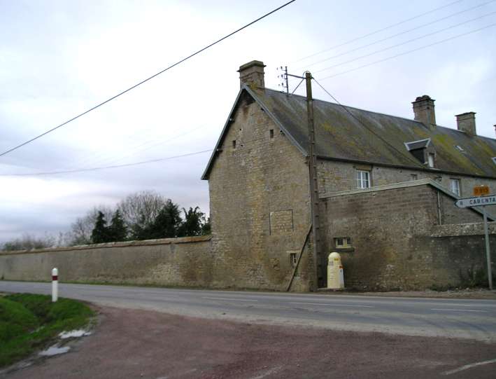
Tumulus de Vierville submitted by thecaptain on 14th Jan 2005. Tumulus de la Butte, Vierville, Manche.
Despite much research, and two visits to this site, I could find no traces of this supposedly wonderful monument, marked on many maps as a notable attraction. My research leads me to believe it is somewhere within this walled garden.
(View photo, vote or add a comment)
Log Text: Try as I might, early in the morning on the way to my sisters from the ferry, by driving up and down every lane and farm track around the village, I couldn’t find any sign of this, despite it being highlighted as a tourist place on the IGN maps. I asked a chap passing on his way to work on a bike if he knew anything of it with no luck, and also an old couple herding cows from one field to another, who said they had lived there all their lives but had also never heard of it. They seemed very intrigued as to what an Englishman was doing in their village asking for a monument and pointing at something on a map. It must have made their day, but it didn’t help me in any way.
After taking a last guess and driving half a mile up a muddy track to the top of a nearby hill, and walking round all the woodland on the top, all I could find was a couple of interested donkeys. An hour had now gone by, and it was time to get on. Not much of a tourist attraction ! Further investigation using more detailed local maps showed the tumulus positioned right opposite the road junction by the church. If accurate, this meant that the tumulus was either in the garden of a large house, or in a nearby farmyard.
Passing near by the site on the way back to the ferry, I stopped off for another look round, this time knowing where to look. There was absolutely no sign of anything to be seen in any farmyards unless it has been covered with either a barn or a dungheap. This left the only place for it to be as in the walled in garden of the large house pictured, which had absolutely no places to look through. I could find nobody around to ask, and didn’t want to just go and call at a perhaps random private house, so had to give up again. It wouldn’t surprise me if it is positioned somewhere under the trees to be seen in the walled garden.
Once home, lots of painstaking research on the internet has revealed nothing more than that it is on private land. Its gotta be in that walled garden. Or is it ?
Tumulus de Montaubert
Trip No.203 Entry No.155 Date Added: 16th Apr 2020
Site Type: Burial Chamber or Dolmen
Country: France (Midi:Aveyron (12))
Visited: Yes on 26th May 2005. My rating: Condition 2 Ambience 3 Access 3
Tumulus de Montaubert submitted by TheCaptain on 10th Apr 2011. Above Salles-la-Source, to the northeast, are roadsigns to the supposedly nicely restored Peyrelebade dolmens, which I did not find.
All I could find for sure while walking north in the scorching heat along the track towards Cadeyrac, was a fenced off small mound in a field to the west of the track.
(View photo, vote or add a comment)
Log Text: Above Salles-la-Source, to the northeast, are roadsigns to the supposedly nicely restored Peyrelevade dolmens, which I did not find. All I could find for sure while walking north in the scorching heat along the track towards Cadeyrac, was a small mound in a field to the west of the track, quite near to where I left the van.
Tumulus de la Boixe B
Trip No.203 Entry No.42 Date Added: 5th Apr 2020
Site Type: Chambered Tomb
Country: France (Poitou:Charente (16))
Visited: Yes on 16th May 2005. My rating: Condition 5 Ambience 5 Access 5
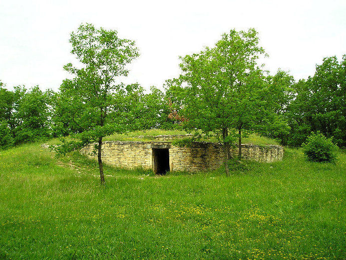
Tumulus de la Boixe B submitted by thecaptain on 4th Jul 2005. In this region to the north of Angoulême are many, many megalithic remains, most of which are almost totally unknown.
This is one of the known sites, the well restored and truly lovely Tumulus de la Boixe, well worth a visit.
(View photo, vote or add a comment)
Log Text: This wonderful tumulus can be found signposted just to the west of the D.116 as it runs through the Forêt-de-Boixe. Said to be one of about 15 such tombs here in the 19th century, but now mostly destroyed.
It’s a lovely tomb, which has been restored, with a chamber still contained fully within its cairn, which must be between 25 and 30 metres in diameter, with two walled and stepped rings around it. A large capstone is still visible from the top which covers the chamber. The entrance passage is slightly curved, and about 8 metres in length.
It looks to me as though many of the stones are new, and indeed some seem to be concrete slabs. There is a side chamber on the right as you go in, which has nicely carved entrance stones giving a fine rounded doorway, with a finely carved edging. Its all very dark inside and you need to take a torch, although the birds like it as it is for nesting inside. The chamber is rectangular, about 3 metres by 1.5 metres. The passageway into the main chamber is exceptionally well made, with most of the stones being very squared, which turns out to be a feature of many of the dolmens around here. The main chamber, more than 8 metres into the tumulus, is another rectangular structure formed with well fitting and squared slabs, and is about 5 metres by 3 metres, wit slab floorstones also.
At the opposite corner of this chamber to where the entrance is, is found another entranceway into a further chamber, this one being about 2 metres square, again made with fantastically fitted stone slabs. The entranceway is carved from two well fitted slabs, and has two grooves carved around it, rather like moulding round a more modern doorway. Above and to the right of this doorway, in the main chamber is a very visible axe carved onto the wall slabs.
Since visiting this tomb, I have found that there are said to be carvings of crooks and axes on one or two of the stones. The monument is in a lovely flower filled clearing in the forest, with the air filled with birdsong, a cuckoo being particularly prominent this morning. It has a noticeboard which states that it is dated to between 4500 and 3700 BC, and that the corridor side stones are original. I went back to my van to get a torch and returned.
Tumulus de Chateaurenaud
Trip No.203 Entry No.46 Date Added: 5th Apr 2020
Site Type: Burial Chamber or Dolmen
Country: France (Poitou:Charente (16))
Visited: Saw from a distance on 16th May 2005
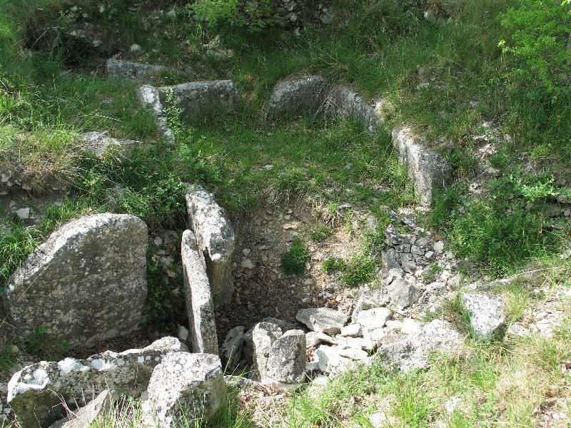
Tumulus de Chateaurenaud submitted by TAUPIN on 15th Nov 2011. Site in Poitou:Charente (16) France
(View photo, vote or add a comment)
Log Text: Another big obvious wood covered tumulus up on the hills above the village. But to get to this one would have meant quite a long walk from anywhere I could have parked and there was no obvious way to it so I did not bother as there are many others to explore locally.
Tumulus de Chassigny
Trip No.204 Entry No.115 Date Added: 4th Aug 2020
Site Type: Round Barrow(s)
Country: France (Poitou:Vienne (86))
Visited: Yes on 18th Jul 2005. My rating: Condition 4 Ambience 3 Access 4
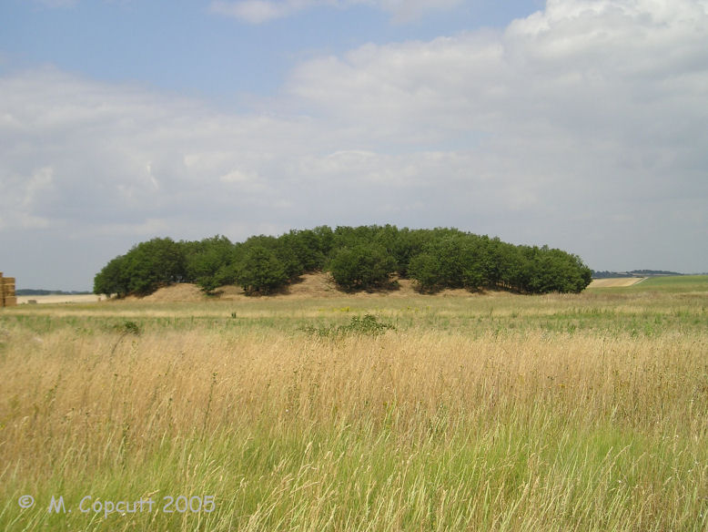
Tumulus de Chassigny submitted by thecaptain on 6th Sep 2009. This is a blinking great big mound, it must be 50 metres in diameter and 10 metres high.
(View photo, vote or add a comment)
Log Text: This is a blinking great big mound, it must be 50 metres in diameter and 10 metres high. It looks to have been well dug into and messed about with, but there is nothing obvious to see except for the large mound. I wonder what is underneath.
Tumuli Landes de Jobourg
Date Added: 29th Oct 2019
Site Type: Barrow Cemetery
Country: France (Normandie:Manche (50))
Visited: Yes on 18th Jan 2019
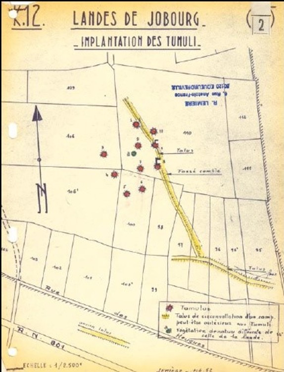
Tumuli Landes de Jobourg submitted by TheCaptain on 18th Jan 2019. Plot of the Joburg Tumuli site by R. Lemière in 1962
(View photo, vote or add a comment)
Log Text: None
Tumuli de Condé-sur-Ifs
Date Added: 18th Sep 2010
Site Type: Chambered Cairn
Country: France (Normandie:Calvados (14))
Visited: Yes on 8th Oct 2006
Tumuli de Condé-sur-Ifs submitted by thecaptain on 8th Oct 2006. Condé-sur-Ifs tumuli, as shown on the sign at Colombiers-sur-Seulles.
(View photo, vote or add a comment)
Log Text: None
Tumiac tumulus
Trip No.203 Entry No.329 Date Added: 4th May 2020
Site Type: Chambered Tomb
Country: France (Bretagne:Morbihan (56))
Visited: Yes on 10th Jun 2005. My rating: Condition 3 Ambience 3 Access 4
Tumiac tumulus submitted by theCaptain on 14th Jun 2012. Information from the noticeboard.
(View photo, vote or add a comment)
Log Text: As driving towards this from the east, it suddenly appears from behind something, before you arrive at the parking area and information sign beside the road. Whoooa, it’s a biggun ! It is said in legend that it is the place from where Caesar watched a great naval battle out to sea to the south of here, but there is not expected to be any truth in this, although from the top there is a tremendous view all around.
The mound is 86 metres in diameter and 20 metres in height, but it only has a single 4 metre by 2 metre magalithic chamber within it, which has been dated to 4700 BC. The insides of the monument are no longer open to public viewing.
Tubby´s Head
Date Added: 5th Oct 2024
Site Type: Promontory Fort / Cliff Castle
Country: England (Cornwall)
Visited: Yes on 5th Aug 2024. My rating: Condition 3 Ambience 4 Access 3

Tubby´s Head submitted by Bladup on 9th Oct 2020. Tubby's Head (mid distance) from the South
(View photo, vote or add a comment)
Log Text: A walk along the coast path from Chapel Porth around St Agnes Head to Trevaunance Cove, meeting up with family for lunch at Schooners bar. A lovely walk with lots of old mine remains, from where we can see Tubby's Head jutting out into the ocean below, just about able to make out some of the defensive ramparts.
Trun menhir
Trip No.202 Entry No.66 Date Added: 29th Mar 2020
Site Type: Standing Stone (Menhir)
Country: France (Normandie:Orne (61))
Visited: Couldn't find on 2nd May 2005
Log Text: There is a menhir somehow incorporated into a southern corner of the church tower of this village where I stopped right by it to buy food and look at the village maps. How stupid I was to miss this one forgetting its existence only while I was there. Its why I went there ! Guess the lateness of getting my lunch was taking its toll.
Truc de Marti
Trip No.205 Entry No.192 Date Added: 25th Nov 2020
Site Type: Ancient Village or Settlement
Country: France (Languedoc:Hérault (34))
Visited: Saw from a distance on 20th Sep 2005
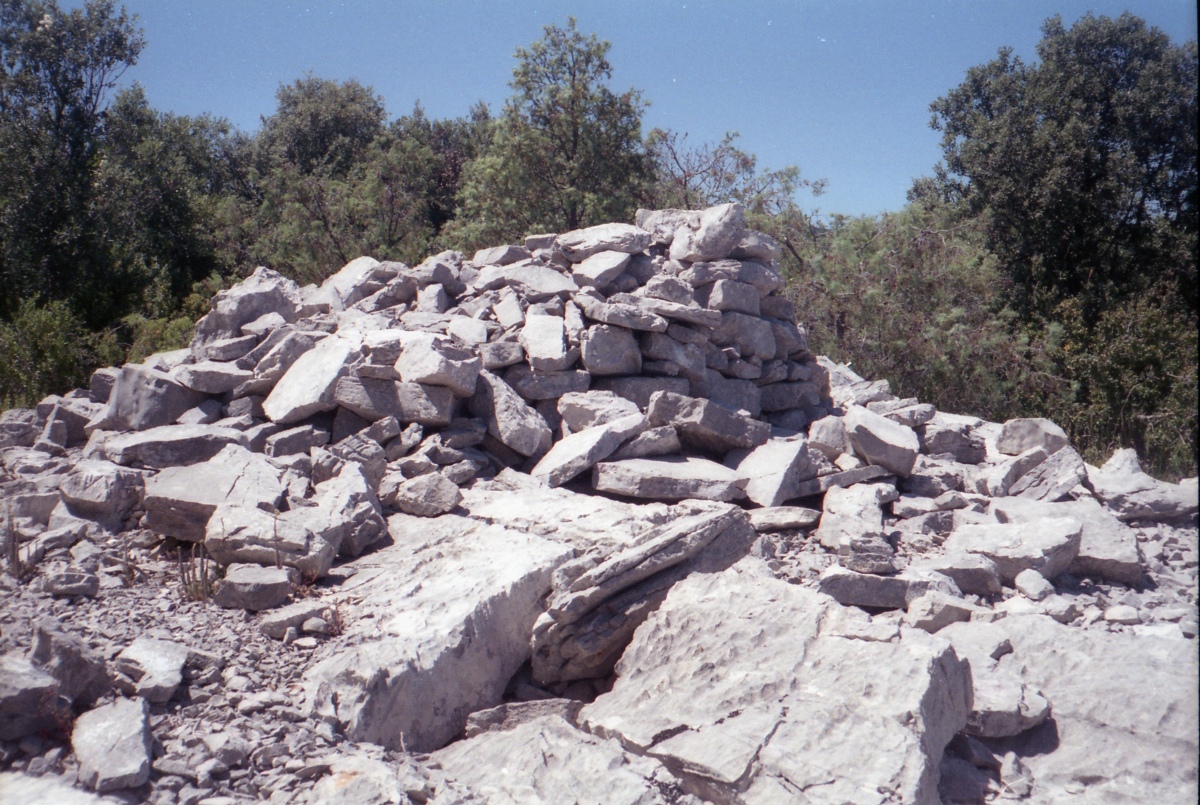
Truc de Marti tombe ovale submitted by johnstone on 30th Mar 2020. Tombe #3, June 26, 2000
(View photo, vote or add a comment)
Log Text: I went to have a look at this hilltop site, but time was getting on, and I could find no quick way up to the top of the hill, which has the remains of a prehistoric village and up to 9 burial chambers on it. I had a look, but could see nothing resembling a path at all, and the place was all very overgrown with rough scrub. I decided that I would probably get lost up there, so I headed off to find a campsite.
Trowlesworthy West row
Date Added: 29th Oct 2019
Site Type: Stone Row / Alignment
Country: England (Devon)
Visited: Yes on 10th Jun 2017
Trowlesworthy West row submitted by TheCaptain on 10th Jun 2017. The junction where the Trowlesworthy West row meets its cairn circle at the upper end.
(View photo, vote or add a comment)
Log Text: None
Trowlesworthy West enclosure
Date Added: 29th Oct 2019
Site Type: Ring Cairn
Country: England (Devon)
Visited: Yes on 22nd May 2013

Trowlesworthy West enclosure submitted by TheCaptain on 22nd May 2013. A little way from the downhill end of the western stone row is a circular enclosure, about 10m in diameter.
I am not sure whether this is some kind of settlement enclosure (too big for hut circle, too small for animal enclosure) or perhaps a ring cairn.
(View photo, vote or add a comment)
Log Text: None
Trowlesworthy West circle
Date Added: 29th Oct 2019
Site Type: Stone Circle
Country: England (Devon)
Visited: Yes on 10th Jun 2017
Trowlesworthy West circle submitted by TheCaptain on 10th Jun 2017. The cairn circle at the uphill end of the Trowlesworthy single stone row.
(View photo, vote or add a comment)
Log Text: None
Trowlesworthy Tor settlement
Date Added: 29th Oct 2019
Site Type: Ancient Village or Settlement
Country: England (Devon)
Visited: Yes on 26th May 2013
Trowlesworthy Tor settlement submitted by theCaptain on 26th May 2013. The slopes of Trowlesworthy Tor are seen in the background of this pic.
Some of the multitudinous remains of the well preserved settlement can be seen, a couple of the circular enclosures clear to the left and one above the leat between markerstone and tor.
(View photo, vote or add a comment)
Log Text: None
Trowlesworthy Tor north settlement
Date Added: 29th Oct 2019
Site Type: Ancient Village or Settlement
Country: England (Devon)
Visited: Yes on 21st May 2013
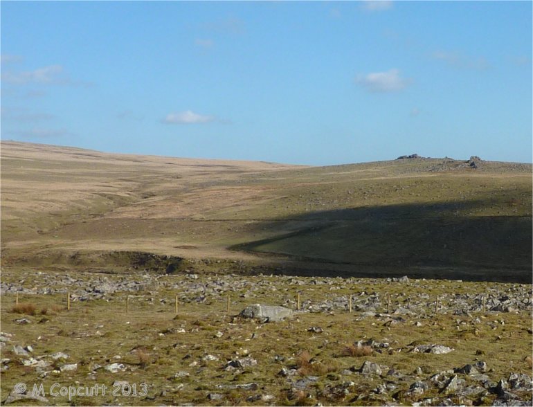
Trowlesworthy Tor north settlement submitted by TheCaptain on 21st May 2013. The view from Legis Tor across the river Plym to Trowlesworthy Tor north settlement.
The settlement remains are in the centre of the photo in the middle distance, below the prominent leat. (most obvious parts in the cloud shadow beside the leakage from the leat)
(View photo, vote or add a comment)
Log Text: None
Trowlesworthy East row
Date Added: 29th Oct 2019
Site Type: Multiple Stone Rows / Avenue
Country: England (Devon)
Visited: Yes on 10th Jun 2017
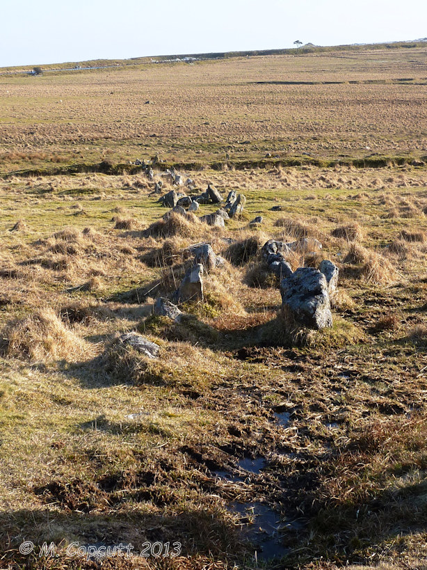
Trowlesworthy East row submitted by TheCaptain on 10th Jun 2017. Seen looking south, the Trowlesworthy East stone row runs down across the hillside from The Pulpit circle.
(View photo, vote or add a comment)
Log Text: None
Trowlesworthy East circle
Date Added: 29th Oct 2019
Site Type: Stone Circle
Country: England (Devon)
Visited: Yes on 12th Sep 2013

Trowlesworthy East circle submitted by TheCaptain on 12th Sep 2013. "The Pulpit" at the head of the Trowlesworthy East stone rows.
Viewed here in April 2013 looking in a south of easterly direction
(View photo, vote or add a comment)
Log Text: None
Trout Hill 3
Date Added: 18th Sep 2010
Site Type: Standing Stones
Country: England (Somerset)
Visited: Yes on 12th Jun 2007
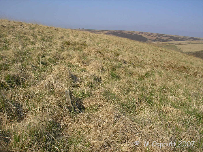
Trout Hill 3 submitted by TheCaptain on 12th Jun 2007. I am not sure that I found the right place, but what I found was the only stone I could find in the long grass anywhere near the given grid reference.
(View photo, vote or add a comment)
Log Text: None
Trout Hill 2
Date Added: 18th Sep 2010
Site Type: Standing Stones
Country: England (Somerset)
Visited: Yes on 26th May 2008
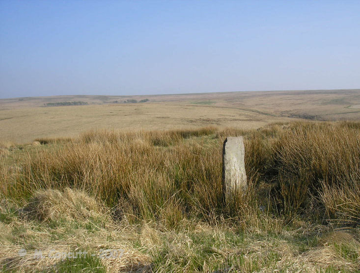
Trout Hill 2 submitted by thecaptain on 26th May 2008. One of the stones is a full metre high, and a splendid stone for Exmoor.
(View photo, vote or add a comment)
Log Text: None
