

<< Our Photo Pages >> La Loge au Loup - Burial Chamber or Dolmen in France in Bretagne:Morbihan (56)
Submitted by thecaptain on Monday, 03 January 2005 Page Views: 4657
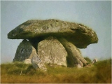
Neolithic and Bronze AgeSite Name: La Loge au Loup Alternative Name: Kerfily dolmenCountry: France Département: Bretagne:Morbihan (56) Type: Burial Chamber or Dolmen
Nearest Town: Vannes Nearest Village: Tredion
Latitude: 47.767330N Longitude: 2.59188W
Condition:
| 5 | Perfect |
| 4 | Almost Perfect |
| 3 | Reasonable but with some damage |
| 2 | Ruined but still recognisable as an ancient site |
| 1 | Pretty much destroyed, possibly visible as crop marks |
| 0 | No data. |
| -1 | Completely destroyed |
| 5 | Superb |
| 4 | Good |
| 3 | Ordinary |
| 2 | Not Good |
| 1 | Awful |
| 0 | No data. |
| 5 | Can be driven to, probably with disabled access |
| 4 | Short walk on a footpath |
| 3 | Requiring a bit more of a walk |
| 2 | A long walk |
| 1 | In the middle of nowhere, a nightmare to find |
| 0 | No data. |
| 5 | co-ordinates taken by GPS or official recorded co-ordinates |
| 4 | co-ordinates scaled from a detailed map |
| 3 | co-ordinates scaled from a bad map |
| 2 | co-ordinates of the nearest village |
| 1 | co-ordinates of the nearest town |
| 0 | no data |
Internal Links:
External Links:
I have visited· I would like to visit
DrewParsons KieKa would like to visit
aolson visited on 19th Jul 2020 - their rating: Cond: 4 Amb: 4 Access: 3 Wonderful place to visit. Interesting to see a different style of structure.
johnstone visited on 22nd Jun 2012 - their rating: Cond: 4 Amb: 5 Access: 4
TheCaptain visited on 11th Jul 2005 - their rating: Cond: 4 Amb: 5 Access: 4 Easily found a few kilometres south of Trédion just to the west of the D.1 road to Elven, this nice site is signposted and has a parking place from where it’s a couple of hundred metres walk up into the lovely woodland on the ridgetop. I thought it to be a strange monument, which looks in some ways to be an Arc Boutté type allée couverte with a V dolmen built on top of it!
The passageway is about 9 metres long and faces 120°, with its paired stones leaning against each other. At the west end is a large capstone, 4 m by 3 m, sitting on top of extra support stones making a sort of chamber 2,5 metres wide, but it is filled up with the leaning stones of the passage. Its almost as if there is a complete V form dolmen built on top of the allée couverte using the same entrance, as there are extra rows of stones outside the passageway. Perhaps the allée couverte was built within the V dolmen. Around the outside are several other shaped stones, no doubt a peristalith of the original mound, of which much remains.
This is a lovely little place to sit in the shade on a hot day, and well worth a visit.
ShamrockStone regina Ogham Jimwithnoname have visited here
Average ratings for this site from all visit loggers: Condition: 4 Ambience: 4.67 Access: 3.67
")
I thought it to be a strange monument, which looks in some ways to be an Arc Boutté type allée couverte with a V dolmen built on top of it!
The passageway is about 9 metres long and faces 120°, with its paired stones leaning against each other. At the west end is a large capstone, 4 m by 3 m, sitting on top of extra support stones making a sort of chamber 2,5 metres wide, but it is filled up with the leaning stones of the passage.
Its almost as if there is a complete V form dolmen built on top of the allée couverte using the same entrance, as there are extra rows of stones outside the passageway. Perhaps the allée couverte was built within the V dolmen. Around the outside are several other shaped stones, no doubt a peristalith of the original mound, of which much remains. This is a lovely little place to sit in the shade on a hot day, and well worth a visit.
You may be viewing yesterday's version of this page. To see the most up to date information please register for a free account.
")
")
")
")
")
")
")
")
")
")
")
")
")
")
")
")
")
")
")
")
Do not use the above information on other web sites or publications without permission of the contributor.
Click here to see more info for this site
Nearby sites
Click here to view sites on an interactive map of the areaKey: Red: member's photo, Blue: 3rd party photo, Yellow: other image, Green: no photo - please go there and take one, Grey: site destroyed
Download sites to:
KML (Google Earth)
GPX (GPS waypoints)
CSV (Garmin/Navman)
CSV (Excel)
To unlock full downloads you need to sign up as a Contributory Member. Otherwise downloads are limited to 50 sites.
Turn off the page maps and other distractions
Nearby sites listing. In the following links * = Image available
895m E 86° La Pierre Branlante (Trédion)* Burial Chamber or Dolmen
1.2km SW 233° Dolmens du Château de Kerfily Burial Chamber or Dolmen
1.4km WNW 288° Menhirs du Bois de Kerfily Standing Stone (Menhir)
1.5km WNW 290° Allée Couverte de Kerfily Passage Grave
1.9km NNE 31° Babouin et Babouine* Standing Stones
2.6km WNW 296° Menhir de Kerdossant Standing Stone (Menhir)
2.7km ESE 105° Menhir de Ker-Antoine Standing Stone (Menhir)
2.7km ESE 121° Dolmen des Miches 1 Burial Chamber or Dolmen
2.7km ESE 122° Dolmen des Miches 2 Burial Chamber or Dolmen
2.8km E 89° Pont Plan* Standing Stone (Menhir)
3.0km E 80° Pierre Tabulaire de la Bataille* Burial Chamber or Dolmen
3.0km ESE 108° Allée Couverte de Coëby Passage Grave
3.4km E 95° Menhirs de Coëby 1* Standing Stones
3.5km NNW 337° Dolmen Prés du Parc Burial Chamber or Dolmen
3.5km E 95° Dolmen de Coëby 2* Burial Chamber or Dolmen
3.6km NNE 16° Dolmen du Stade Burial Chamber or Dolmen
3.7km N 357° Grande Villeneuve Menhir* Standing Stone (Menhir)
3.9km E 85° Dolmen de Coëby 5 Burial Chamber or Dolmen
3.9km E 89° Dolmen de Coëby 3 Burial Chamber or Dolmen
3.9km E 90° Dolmen de Coëby 4 Burial Chamber or Dolmen
4.1km ENE 70° Grand Breuil Menhir* Standing Stone (Menhir)
4.1km NNW 333° Allée Couverte du Prés-du-Parc Passage Grave
4.4km E 87° Dolmen de Coëby 1* Burial Chamber or Dolmen
4.5km E 100° Menhir de la Forêt de Molac 3 Standing Stone (Menhir)
4.5km E 97° Dolmen de la Forêt de Molac 2 Burial Chamber or Dolmen
View more nearby sites and additional images


 We would like to know more about this location. Please feel free to add a brief description and any relevant information in your own language.
 Wir möchten mehr über diese Stätte erfahren. Bitte zögern Sie nicht, eine kurze Beschreibung und relevante Informationen in Deutsch hinzuzufügen.
 Nous aimerions en savoir encore un peu sur les lieux. S'il vous plaît n'hesitez pas à ajouter une courte description et tous les renseignements pertinents dans votre propre langue.
 Quisieramos informarnos un poco más de las lugares. No dude en añadir una breve descripción y otros datos relevantes en su propio idioma.