

<< Our Photo Pages >> Grande Villeneuve Menhir - Standing Stone (Menhir) in France in Bretagne:Morbihan (56)
Submitted by TheCaptain on Monday, 03 January 2005 Page Views: 2990
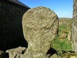
Neolithic and Bronze AgeSite Name: Grande Villeneuve Menhir Alternative Name: Menhir de Grande-VilleneuveCountry: France Département: Bretagne:Morbihan (56) Type: Standing Stone (Menhir)
Nearest Town: Vannes Nearest Village: Tredion
Latitude: 47.800700N Longitude: 2.5941W
Condition:
| 5 | Perfect |
| 4 | Almost Perfect |
| 3 | Reasonable but with some damage |
| 2 | Ruined but still recognisable as an ancient site |
| 1 | Pretty much destroyed, possibly visible as crop marks |
| 0 | No data. |
| -1 | Completely destroyed |
| 5 | Superb |
| 4 | Good |
| 3 | Ordinary |
| 2 | Not Good |
| 1 | Awful |
| 0 | No data. |
| 5 | Can be driven to, probably with disabled access |
| 4 | Short walk on a footpath |
| 3 | Requiring a bit more of a walk |
| 2 | A long walk |
| 1 | In the middle of nowhere, a nightmare to find |
| 0 | No data. |
| 5 | co-ordinates taken by GPS or official recorded co-ordinates |
| 4 | co-ordinates scaled from a detailed map |
| 3 | co-ordinates scaled from a bad map |
| 2 | co-ordinates of the nearest village |
| 1 | co-ordinates of the nearest town |
| 0 | no data |
Internal Links:
External Links:
I have visited· I would like to visit
johnstone visited on 22nd Jun 2012 - their rating: Cond: 3 Amb: 3 Access: 5
TheCaptain visited on 11th Jul 2005 - their rating: Cond: 3 Amb: 3 Access: 5 This menhir is to be found in a garden in the hamlet of the same name, a kilometre or so to the north of Tredion. The menhir is about 4 metres tall and nicely shaped, although it looks to have lost its top at some point, due to a lightning strike.
Average ratings for this site from all visit loggers: Condition: 3 Ambience: 3 Access: 5
")
Wikipedia article
Liste des sites mégalithiques du Morbihan
You may be viewing yesterday's version of this page. To see the most up to date information please register for a free account.
")
")
")
")
Do not use the above information on other web sites or publications without permission of the contributor.
Nearby Images from Flickr


The above images may not be of the site on this page, but were taken nearby. They are loaded from Flickr so please click on them for image credits.
Click here to see more info for this site
Nearby sites
Click here to view sites on an interactive map of the areaKey: Red: member's photo, Blue: 3rd party photo, Yellow: other image, Green: no photo - please go there and take one, Grey: site destroyed
Download sites to:
KML (Google Earth)
GPX (GPS waypoints)
CSV (Garmin/Navman)
CSV (Excel)
To unlock full downloads you need to sign up as a Contributory Member. Otherwise downloads are limited to 50 sites.
Turn off the page maps and other distractions
Nearby sites listing. In the following links * = Image available
1.2km ESE 103° Dolmen du Stade Burial Chamber or Dolmen
1.3km WSW 246° Dolmen Prés du Parc Burial Chamber or Dolmen
1.7km W 268° Allée Couverte du Prés-du-Parc Passage Grave
2.4km SSE 152° Babouin et Babouine* Standing Stones
3.4km SW 221° Menhir de Kerdossant Standing Stone (Menhir)
3.4km SSW 201° Allée Couverte de Kerfily Passage Grave
3.5km SSW 200° Menhirs du Bois de Kerfily Standing Stone (Menhir)
3.7km S 177° La Loge au Loup* Burial Chamber or Dolmen
3.8km SSE 164° La Pierre Branlante (Trédion)* Burial Chamber or Dolmen
4.0km WNW 293° Roche de Migourdy* Burial Chamber or Dolmen
4.3km WSW 250° Menhir de Kervazy 2 Standing Stone (Menhir)
4.3km WSW 249° Menhir de Kervazy 1 Standing Stone (Menhir)
4.5km SE 136° Pierre Tabulaire de la Bataille* Burial Chamber or Dolmen
4.5km WSW 248° Allée couverte de Pont-Bertho Passage Grave
4.5km S 190° Dolmens du Château de Kerfily Burial Chamber or Dolmen
4.6km WSW 251° Menhir de Cadoudal Standing Stone (Menhir)
4.6km WSW 250° Pierre de Pont Bertho Standing Stone (Menhir)
4.6km ESE 120° Grand Breuil Menhir* Standing Stone (Menhir)
4.7km WSW 243° Menhirs de Pont-Bertho 1 Standing Stones
4.7km SE 141° Pont Plan* Standing Stone (Menhir)
4.7km ESE 107° Menhir Fourchu* Standing Stone (Menhir)
5.2km SSE 148° Menhir de Ker-Antoine Standing Stone (Menhir)
5.3km SE 130° Dolmen de Coëby 5 Burial Chamber or Dolmen
5.3km W 267° Allée Couverte de Kerlano Passage Grave
5.3km ESE 119° Menhirs de Belle Alouette* Standing Stones
View more nearby sites and additional images


 We would like to know more about this location. Please feel free to add a brief description and any relevant information in your own language.
 Wir möchten mehr über diese Stätte erfahren. Bitte zögern Sie nicht, eine kurze Beschreibung und relevante Informationen in Deutsch hinzuzufügen.
 Nous aimerions en savoir encore un peu sur les lieux. S'il vous plaît n'hesitez pas à ajouter une courte description et tous les renseignements pertinents dans votre propre langue.
 Quisieramos informarnos un poco más de las lugares. No dude en añadir una breve descripción y otros datos relevantes en su propio idioma.