

<< Our Photo Pages >> Kerara Menhir - Standing Stone (Menhir) in France in Bretagne:Morbihan (56)
Submitted by TheCaptain on Monday, 03 January 2005 Page Views: 4965
Neolithic and Bronze AgeSite Name: Kerara Menhir Alternative Name: Menhir de KeraraCountry: France Département: Bretagne:Morbihan (56) Type: Standing Stone (Menhir)
Nearest Town: Vannes Nearest Village: Moustoir-Ac
Latitude: 47.822900N Longitude: 2.8566W
Condition:
| 5 | Perfect |
| 4 | Almost Perfect |
| 3 | Reasonable but with some damage |
| 2 | Ruined but still recognisable as an ancient site |
| 1 | Pretty much destroyed, possibly visible as crop marks |
| 0 | No data. |
| -1 | Completely destroyed |
| 5 | Superb |
| 4 | Good |
| 3 | Ordinary |
| 2 | Not Good |
| 1 | Awful |
| 0 | No data. |
| 5 | Can be driven to, probably with disabled access |
| 4 | Short walk on a footpath |
| 3 | Requiring a bit more of a walk |
| 2 | A long walk |
| 1 | In the middle of nowhere, a nightmare to find |
| 0 | No data. |
| 5 | co-ordinates taken by GPS or official recorded co-ordinates |
| 4 | co-ordinates scaled from a detailed map |
| 3 | co-ordinates scaled from a bad map |
| 2 | co-ordinates of the nearest village |
| 1 | co-ordinates of the nearest town |
| 0 | no data |
Internal Links:
External Links:
I have visited· I would like to visit
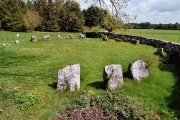
TheCaptain visited on 12th Jul 2005 - their rating: Cond: 4 Amb: 4 Access: 4 This is a nice shaped menhir, just under 4 metres tall, standing in a little clearing in an area of many natural granite rocks. It is just beside the road and has a parking place and signpost, from which it is about a 50 metre walk. Its got some lovely shade for this very hot and sunny afternoon. It is only a few hundred metres from the large Kermarquer menhir.
johnstone visited on 6th Jul 2005 - their rating: Cond: 4 Amb: 4 Access: 4
Ogham have visited here
Average ratings for this site from all visit loggers: Condition: 4 Ambience: 4 Access: 4
")
There is probably a second fallen menhir nearby.
It is only a few hundred metres from the large Kermarquer menhir.
Wikipedia article
Liste des sites mégalithiques du Morbihan
Base Mérimée (Historic Monument)
You may be viewing yesterday's version of this page. To see the most up to date information please register for a free account.
")
")
")
")
")
Do not use the above information on other web sites or publications without permission of the contributor.
Click here to see more info for this site
Nearby sites
Click here to view sites on an interactive map of the areaKey: Red: member's photo, Blue: 3rd party photo, Yellow: other image, Green: no photo - please go there and take one, Grey: site destroyed
Download sites to:
KML (Google Earth)
GPX (GPS waypoints)
CSV (Garmin/Navman)
CSV (Excel)
To unlock full downloads you need to sign up as a Contributory Member. Otherwise downloads are limited to 50 sites.
Turn off the page maps and other distractions
Nearby sites listing. In the following links * = Image available
276m NW 324° Kermarquer menhir* Standing Stone (Menhir)
392m NW 309° Men-Brasi-de-Kermar-Ker* Standing Stone (Menhir)
1.7km NNE 15° Menhir du Mené* Standing Stone (Menhir)
1.8km N 359° Mégalithe-siège, Kerhero* Natural Stone / Erratic / Other Natural Feature
1.8km NNW 345° Pierres de Kerguéris* Natural Stone / Erratic / Other Natural Feature
2.1km WNW 282° Cosquéro Menhir* Standing Stone (Menhir)
2.4km W 268° Menhir de Kerigo Standing Stone (Menhir)
2.9km N 357° Kermorvan Dolmen* Burial Chamber or Dolmen
4.6km SE 143° Cairn de Lost-er-Lenn Cairn
5.1km ESE 112° Larcuste cairns 1* Chambered Cairn
5.1km ESE 113° Larcuste cairns 2* Chambered Cairn
5.1km ESE 112° Larcuste Cairns* Chambered Cairn
5.1km ESE 113° Larcuste cairns 3* Chambered Cairn
5.9km SE 142° Ty Neüé menhir couché* Standing Stone (Menhir)
5.9km ENE 58° Bézo menhir* Standing Stone (Menhir)
6.5km E 83° Kerjagu Menhirs* Standing Stones
6.5km W 266° Dolmen de Soucho Burial Chamber or Dolmen
6.5km E 83° Kerjagu allée couverte* Passage Grave
6.9km WNW 287° Dolmen de Roh Du 2 Burial Chamber or Dolmen
6.9km WNW 285° Dolmen de Roh Du 1* Burial Chamber or Dolmen
7.4km W 272° Menhir dit la Croix Blanche (Morbihan) Standing Stone (Menhir)
7.4km WNW 284° Dolmen de Roh Du 3 Burial Chamber or Dolmen
7.7km NE 37° Kergonfalz Tumulus* Chambered Tomb
7.7km NE 38° Kergonfalz allée couverte* Passage Grave
7.8km E 99° Goh Menhir menhir* Standing Stone (Menhir)
View more nearby sites and additional images


 We would like to know more about this location. Please feel free to add a brief description and any relevant information in your own language.
 Wir möchten mehr über diese Stätte erfahren. Bitte zögern Sie nicht, eine kurze Beschreibung und relevante Informationen in Deutsch hinzuzufügen.
 Nous aimerions en savoir encore un peu sur les lieux. S'il vous plaît n'hesitez pas à ajouter une courte description et tous les renseignements pertinents dans votre propre langue.
 Quisieramos informarnos un poco más de las lugares. No dude en añadir una breve descripción y otros datos relevantes en su propio idioma.