

<< Text Pages >> Menhir de Kerven (Peumérit) - Standing Stone (Menhir) in France in Bretagne:Finistère (29)
Submitted by TheCaptain on Tuesday, 28 December 2004 Page Views: 2106
Neolithic and Bronze AgeSite Name: Menhir de Kerven (Peumérit)Country: France Département: Bretagne:Finistère (29) Type: Standing Stone (Menhir)
Nearest Town: Quimper Nearest Village: Peumerit
Latitude: 47.959650N Longitude: 4.31164W
Condition:
| 5 | Perfect |
| 4 | Almost Perfect |
| 3 | Reasonable but with some damage |
| 2 | Ruined but still recognisable as an ancient site |
| 1 | Pretty much destroyed, possibly visible as crop marks |
| 0 | No data. |
| -1 | Completely destroyed |
| 5 | Superb |
| 4 | Good |
| 3 | Ordinary |
| 2 | Not Good |
| 1 | Awful |
| 0 | No data. |
| 5 | Can be driven to, probably with disabled access |
| 4 | Short walk on a footpath |
| 3 | Requiring a bit more of a walk |
| 2 | A long walk |
| 1 | In the middle of nowhere, a nightmare to find |
| 0 | No data. |
| 5 | co-ordinates taken by GPS or official recorded co-ordinates |
| 4 | co-ordinates scaled from a detailed map |
| 3 | co-ordinates scaled from a bad map |
| 2 | co-ordinates of the nearest village |
| 1 | co-ordinates of the nearest town |
| 0 | no data |
Be the first person to rate this site - see the 'Contribute!' box in the right hand menu.
Internal Links:
External Links:
Menhir in Finistère
Location Source: T4T35
Information and Pictures:
megalithes-breton.fr
You may be viewing yesterday's version of this page. To see the most up to date information please register for a free account.
Do not use the above information on other web sites or publications without permission of the contributor.
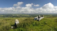
Nearby Images from Flickr
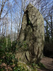
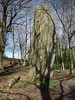
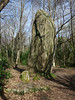

The above images may not be of the site on this page, but were taken nearby. They are loaded from Flickr so please click on them for image credits.
Click here to see more info for this site
Nearby sites
Click here to view sites on an interactive map of the areaKey: Red: member's photo, Blue: 3rd party photo, Yellow: other image, Green: no photo - please go there and take one, Grey: site destroyed
Download sites to:
KML (Google Earth)
GPX (GPS waypoints)
CSV (Garmin/Navman)
CSV (Excel)
To unlock full downloads you need to sign up as a Contributory Member. Otherwise downloads are limited to 50 sites.
Turn off the page maps and other distractions
Nearby sites listing. In the following links * = Image available
85m WSW 255° Ruot Nevez menhir Standing Stone (Menhir)
1.0km S 170° Menhir de Kerloazec 2 Standing Stone (Menhir)
1.1km S 185° Dolmen de Penquélenne* Burial Chamber or Dolmen
1.1km SW 234° Lespurit-Quélen menhir* Standing Stone (Menhir)
1.2km S 169° Menhir de Kerloazec 1 Standing Stone (Menhir)
1.6km W 262° Menhir de Kerguelven Standing Stone (Menhir)
2.1km WSW 256° Menez Roz Tuchic menhir Standing Stone (Menhir)
2.1km WSW 256° Menhir de Kerglogé 2* Standing Stone (Menhir)
2.1km WSW 256° Menhir de Kerglogé 1* Standing Stone (Menhir)
2.5km WSW 242° Saint-Kodelig menhir* Standing Stone (Menhir)
2.5km NW 314° Lesvoe menhir Standing Stone (Menhir)
2.6km WSW 251° Allée Couverte de Plovan Passage Grave
2.8km WSW 250° Menhir de Kersourou Standing Stone (Menhir)
3.2km SSW 203° Menhirs de Kerloazec* Standing Stone (Menhir)
3.6km W 259° Peulven menhir (Pouldreuzic) Standing Stone (Menhir)
4.0km NE 41° Menhir de la Cité du Roz Standing Stone (Menhir)
4.8km WNW 286° Menhirs de Kerdelec* Standing Stone (Menhir)
5.5km SW 216° Menhir de Croaspilo Standing Stone (Menhir)
5.7km WNW 289° Menhir de Kervinou (Plozévet) Standing Stone (Menhir)
5.9km WSW 240° Crugou et Renongar* Chambered Tomb
6.3km SSW 197° Penhors stèle* Standing Stone (Menhir)
6.4km WNW 288° Menhir de Lestrouquy* Standing Stone (Menhir)
6.5km WSW 240° Corn-ar-Palud* Chambered Cairn
6.6km SSE 161° Stèle À Bonnet D'Evêque* Standing Stone (Menhir)
7.0km SSE 160° Trois Dolmens Burial Chamber or Dolmen
View more nearby sites and additional images


 We would like to know more about this location. Please feel free to add a brief description and any relevant information in your own language.
 Wir möchten mehr über diese Stätte erfahren. Bitte zögern Sie nicht, eine kurze Beschreibung und relevante Informationen in Deutsch hinzuzufügen.
 Nous aimerions en savoir encore un peu sur les lieux. S'il vous plaît n'hesitez pas à ajouter une courte description et tous les renseignements pertinents dans votre propre langue.
 Quisieramos informarnos un poco más de las lugares. No dude en añadir una breve descripción y otros datos relevantes en su propio idioma.