 with our Megalithic Portal iPhone app")


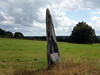
<< Our Photo Pages >> Kerzunis-Vihan menhir - Standing Stone (Menhir) in France in Bretagne:Finistère (29)
Submitted by TheCaptain on Tuesday, 28 December 2004 Page Views: 2064
Neolithic and Bronze AgeSite Name: Kerzunis-Vihan menhirCountry: France Département: Bretagne:Finistère (29) Type: Standing Stone (Menhir)
Nearest Town: Quimper Nearest Village: Laz
Latitude: 48.134180N Longitude: 3.76877W
Condition:
| 5 | Perfect |
| 4 | Almost Perfect |
| 3 | Reasonable but with some damage |
| 2 | Ruined but still recognisable as an ancient site |
| 1 | Pretty much destroyed, possibly visible as crop marks |
| 0 | No data. |
| -1 | Completely destroyed |
| 5 | Superb |
| 4 | Good |
| 3 | Ordinary |
| 2 | Not Good |
| 1 | Awful |
| 0 | No data. |
| 5 | Can be driven to, probably with disabled access |
| 4 | Short walk on a footpath |
| 3 | Requiring a bit more of a walk |
| 2 | A long walk |
| 1 | In the middle of nowhere, a nightmare to find |
| 0 | No data. |
| 5 | co-ordinates taken by GPS or official recorded co-ordinates |
| 4 | co-ordinates scaled from a detailed map |
| 3 | co-ordinates scaled from a bad map |
| 2 | co-ordinates of the nearest village |
| 1 | co-ordinates of the nearest town |
| 0 | no data |
Internal Links:
External Links:
")
IMPORTANT NOTE: Site believed to be near this position
You may be viewing yesterday's version of this page. To see the most up to date information please register for a free account.
")
Do not use the above information on other web sites or publications without permission of the contributor.
Nearby Images from Flickr
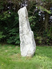
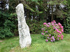
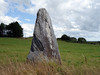
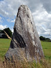
The above images may not be of the site on this page, but were taken nearby. They are loaded from Flickr so please click on them for image credits.
Click here to see more info for this site
Nearby sites
Click here to view sites on an interactive map of the areaKey: Red: member's photo, Blue: 3rd party photo, Yellow: other image, Green: no photo - please go there and take one, Grey: site destroyed
Download sites to:
KML (Google Earth)
GPX (GPS waypoints)
CSV (Garmin/Navman)
CSV (Excel)
To unlock full downloads you need to sign up as a Contributory Member. Otherwise downloads are limited to 50 sites.
Turn off the page maps and other distractions
Nearby sites listing. In the following links * = Image available
278m NE 34° menhir du Mendi* Standing Stone (Menhir)
827m NW 312° Alignement dit Tri Men* Standing Stones
1.1km NE 44° Kroaz An Teureg alignement* Stone Row / Alignment
1.4km NE 48° Menhir de Croaz An Teurec 2* Standing Stone (Menhir)
2.8km NNW 348° Allée Couverte de Quillien Passage Grave
2.9km NNE 21° Allée Couverte de Kerdreign Passage Grave
3.2km ENE 68° Castel-Ruphel* Passage Grave
3.4km NNW 342° Ty Sant Denez allée couverte Passage Grave
3.6km WSW 239° Menhir de Kermez Standing Stone (Menhir)
3.7km NW 310° Coffres de Kerregou Cist
4.3km SSE 165° Men Berr menhir Standing Stone (Menhir)
4.9km ENE 65° Menhir de Guernevez Standing Stone (Menhir)
5.0km SSE 164° Men-Hir menhir* Standing Stone (Menhir)
5.0km ENE 66° Allée Couverte dite Ty-Sant-Denez Passage Grave
5.5km ENE 65° Alignement du Bois du Duc* Standing Stone (Menhir)
5.7km ENE 77° Alignement de Guernangoué* Stone Row / Alignment
6.2km NNE 21° Menhir de Kerescan Standing Stone (Menhir)
8.0km NE 34° Menhir du Bois du Duc* Standing Stone (Menhir)
8.1km NNE 27° Allée Couverte de Kerbasqued Passage Grave
8.1km ESE 119° Petit Moustoir menhir Standing Stone (Menhir)
8.2km ESE 117° Allée Couverte de Kergus* Passage Grave
8.2km ESE 121° Kerbiguetlan Menhir* Standing Stone (Menhir)
9.4km SSW 210° Deux Alignements Stone Row / Alignment
10.3km WNW 283° Tumulus de Ty-Floc'h* Chambered Cairn
12.8km WNW 297° Dolmen de Pendréau* Burial Chamber or Dolmen
View more nearby sites and additional images


 We would like to know more about this location. Please feel free to add a brief description and any relevant information in your own language.
 Wir möchten mehr über diese Stätte erfahren. Bitte zögern Sie nicht, eine kurze Beschreibung und relevante Informationen in Deutsch hinzuzufügen.
 Nous aimerions en savoir encore un peu sur les lieux. S'il vous plaît n'hesitez pas à ajouter une courte description et tous les renseignements pertinents dans votre propre langue.
 Quisieramos informarnos un poco más de las lugares. No dude en añadir una breve descripción y otros datos relevantes en su propio idioma.