

<< Our Photo Pages >> Dolmen de Cosqueriou d'An Traon - Burial Chamber or Dolmen in France in Bretagne:Finistère (29)
Submitted by TheCaptain on Tuesday, 28 December 2004 Page Views: 2424
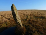
Neolithic and Bronze AgeSite Name: Dolmen de Cosqueriou d'An TraonCountry: France Département: Bretagne:Finistère (29) Type: Burial Chamber or Dolmen
Nearest Town: Quimperlé Nearest Village: Bannalec
Latitude: 47.911470N Longitude: 3.63142W
Condition:
| 5 | Perfect |
| 4 | Almost Perfect |
| 3 | Reasonable but with some damage |
| 2 | Ruined but still recognisable as an ancient site |
| 1 | Pretty much destroyed, possibly visible as crop marks |
| 0 | No data. |
| -1 | Completely destroyed |
| 5 | Superb |
| 4 | Good |
| 3 | Ordinary |
| 2 | Not Good |
| 1 | Awful |
| 0 | No data. |
| 5 | Can be driven to, probably with disabled access |
| 4 | Short walk on a footpath |
| 3 | Requiring a bit more of a walk |
| 2 | A long walk |
| 1 | In the middle of nowhere, a nightmare to find |
| 0 | No data. |
| 5 | co-ordinates taken by GPS or official recorded co-ordinates |
| 4 | co-ordinates scaled from a detailed map |
| 3 | co-ordinates scaled from a bad map |
| 2 | co-ordinates of the nearest village |
| 1 | co-ordinates of the nearest town |
| 0 | no data |
Internal Links:
External Links:
I have visited· I would like to visit
johnstone visited on 21st Jun 2004 - their rating: Cond: 3 Amb: 3 Access: 5
")
Base Mérimée (Historic Monument)
You may be viewing yesterday's version of this page. To see the most up to date information please register for a free account.
Do not use the above information on other web sites or publications without permission of the contributor.
Nearby Images from Flickr

The above images may not be of the site on this page, but were taken nearby. They are loaded from Flickr so please click on them for image credits.
Click here to see more info for this site
Nearby sites
Click here to view sites on an interactive map of the areaKey: Red: member's photo, Blue: 3rd party photo, Yellow: other image, Green: no photo - please go there and take one, Grey: site destroyed
Download sites to:
KML (Google Earth)
GPX (GPS waypoints)
CSV (Garmin/Navman)
CSV (Excel)
To unlock full downloads you need to sign up as a Contributory Member. Otherwise downloads are limited to 50 sites.
Turn off the page maps and other distractions
Nearby sites listing. In the following links * = Image available
3.9km SSW 201° Laniscar menhir* Standing Stone (Menhir)
4.8km NW 306° Dolmen de Sainte-Anne* Burial Chamber or Dolmen
5.3km SW 217° Goalichot Dolmen* Burial Chamber or Dolmen
5.3km ENE 65° Dolmen de Kernobis Burial Chamber or Dolmen
5.6km WSW 248° Kerscao Dolmen* Burial Chamber or Dolmen
6.3km W 277° Trémeur menhir Standing Stone (Menhir)
6.6km WSW 258° Dolmen de Kercoat* Burial Chamber or Dolmen
7.0km SSW 194° Menhir de Kerfary* Standing Stone (Menhir)
7.1km W 267° Allée Couverte de Kermaout* Passage Grave
7.2km SSW 196° Kerregenn Ron* Standing Stone (Menhir)
7.6km WSW 258° Allée Couverte de l'Eglise Blanche Passage Grave
8.3km SSE 151° Dolmen de Toul-ar-Bleiz Burial Chamber or Dolmen
8.5km S 181° Menhir dit le Bonheur des Dames* Standing Stone (Menhir)
8.5km SSW 197° Allée Couverte de Kerléon Passage Grave
9.1km ESE 123° Dolmen de Keransquer Burial Chamber or Dolmen
9.5km SE 140° Pierre Redressée Standing Stone (Menhir)
9.7km WSW 245° Dolmen de la Chapelle Saint-Maudé* Burial Chamber or Dolmen
9.8km SSW 204° Allée Couverte de Saint-Julien* Passage Grave
9.8km S 184° Dolmen del Guilly Burial Chamber or Dolmen
9.8km SE 141° Dolmen de Toulfoën Burial Chamber or Dolmen
10.1km SE 138° Forêt de Carnoët 1 tumulus Chambered Tomb
10.2km W 262° Moulin René* Passage Grave
10.3km ESE 121° Dolmen de Roscasquen* Burial Chamber or Dolmen
10.4km SSE 151° Forêt de Carnoët 2 tumulus Chambered Tomb
10.4km S 186° Menhir de Guily* Standing Stone (Menhir)
View more nearby sites and additional images


 We would like to know more about this location. Please feel free to add a brief description and any relevant information in your own language.
 Wir möchten mehr über diese Stätte erfahren. Bitte zögern Sie nicht, eine kurze Beschreibung und relevante Informationen in Deutsch hinzuzufügen.
 Nous aimerions en savoir encore un peu sur les lieux. S'il vous plaît n'hesitez pas à ajouter une courte description et tous les renseignements pertinents dans votre propre langue.
 Quisieramos informarnos un poco más de las lugares. No dude en añadir una breve descripción y otros datos relevantes en su propio idioma.