

<< Our Photo Pages >> L'Hotié de Viviane - Chambered Tomb in France in Bretagne:Ille-et-Vilaine (35)
Submitted by TheCaptain on Wednesday, 06 June 2007 Page Views: 6366
Neolithic and Bronze AgeSite Name: L'Hotié de Viviane Alternative Name: Maison de Viviane, Tombeau des DruidesCountry: France Département: Bretagne:Ille-et-Vilaine (35) Type: Chambered Tomb
Nearest Town: Ploermel Nearest Village: Paimpont
Latitude: 48.000120N Longitude: 2.2687W
Condition:
| 5 | Perfect |
| 4 | Almost Perfect |
| 3 | Reasonable but with some damage |
| 2 | Ruined but still recognisable as an ancient site |
| 1 | Pretty much destroyed, possibly visible as crop marks |
| 0 | No data. |
| -1 | Completely destroyed |
| 5 | Superb |
| 4 | Good |
| 3 | Ordinary |
| 2 | Not Good |
| 1 | Awful |
| 0 | No data. |
| 5 | Can be driven to, probably with disabled access |
| 4 | Short walk on a footpath |
| 3 | Requiring a bit more of a walk |
| 2 | A long walk |
| 1 | In the middle of nowhere, a nightmare to find |
| 0 | No data. |
| 5 | co-ordinates taken by GPS or official recorded co-ordinates |
| 4 | co-ordinates scaled from a detailed map |
| 3 | co-ordinates scaled from a bad map |
| 2 | co-ordinates of the nearest village |
| 1 | co-ordinates of the nearest town |
| 0 | no data |
Internal Links:
External Links:
I have visited· I would like to visit
43559959 DrewParsons SumDoood would like to visit
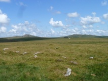
TheCaptain visited on 10th Jul 2005 - their rating: Cond: 3 Amb: 5 Access: 3 This can be found about a kilometre walk from the same car park that is used to visit the Tombeau des Géants, but in the other direction. It is signposted. Just below and to the north of a ridge with tremendous views can be found this little grave, about 3 metres long and 1 metre wide, made with 1.5 metre tall side slabs. It is enclosed within a 12 metre diameter stone cairn with a ring of stones around the outside. It is supposedly a rarity in Brittany, but reminds me of a more complete version of the smaller tombelles near to the Rocher de Bono.
The site was excavated in 1982/1983, when pottery and polished axes were found, and it was carbon dated to about 3000 BC. It is also know b ythe name "Tombeau des Druides.
johnstone visited on 9th Jun 2004 - their rating: Cond: 3 Amb: 5 Access: 3
Ogham have visited here
Average ratings for this site from all visit loggers: Condition: 3 Ambience: 5 Access: 3
")
It is supposedly a rarity in Brittany, but it reminds me of a more complete version of the smaller tombelles near to the Rocher de Bono.
The site was excavated in 1982/1983, when pottery and polished axes were found, and it was carbon dated to about 3000 BC. It is also know by the name "Tombeau des Druides. This can be found about a kilometre walk from the same car park that is used to visit the Tombeau des Géants, but in the other direction, it is signposted.
Base Mérimée (Patrimonial Inventory)
You may be viewing yesterday's version of this page. To see the most up to date information please register for a free account.
")
")
")
")
")
")
")
Do not use the above information on other web sites or publications without permission of the contributor.
Click here to see more info for this site
Nearby sites
Click here to view sites on an interactive map of the areaKey: Red: member's photo, Blue: 3rd party photo, Yellow: other image, Green: no photo - please go there and take one, Grey: site destroyed
Download sites to:
KML (Google Earth)
GPX (GPS waypoints)
CSV (Garmin/Navman)
CSV (Excel)
To unlock full downloads you need to sign up as a Contributory Member. Otherwise downloads are limited to 50 sites.
Turn off the page maps and other distractions
Nearby sites listing. In the following links * = Image available
99m N 350° Sépulture mégalithique de Rauco Cist
913m ENE 71° Coffre de la Guette Burial Chamber or Dolmen
915m S 182° Tombeau des Géants* Passage Grave
1.7km WNW 303° Fontaine Ste-Onenn Holy Well or Sacred Spring
1.8km SSE 151° Le Tombeau du Géant* Chambered Tomb
2.4km NW 315° Butte-Ronde Chambered Tomb
2.7km NW 325° Jardin-aux-Moines tumulus* Chambered Tomb
4.0km E 95° Allée Couverte de l'Orgeril Passage Grave
4.6km NNE 21° Fontaine de Barenton* Holy Well or Sacred Spring
6.1km S 175° Allée Couverte de Brambelay Passage Grave
8.0km SSE 167° Allée couverte dite de Roherman* Passage Grave
8.8km WSW 236° Hino allée couverte* Passage Grave
9.1km N 352° Dolmen dit Pierre des Champs-Morgan Burial Chamber or Dolmen
9.1km NNE 20° Allée Couverte dite Le Rocher Passage Grave
12.1km SSE 149° Allée Couverte dite le Tombeau des Rochettes Passage Grave
12.3km S 184° Allée couverte dite la Roche des Fées* Passage Grave
13.1km SSE 150° La Verrie menhir* Standing Stone (Menhir)
13.4km SSE 162° Allée Couverte dite Château d'Eau Passage Grave
13.5km SSE 158° Lande de Rousse* Standing Stones
13.6km NE 47° Tombeau des Anglais (Paimpont)* Passage Grave
13.6km SSE 156° La Loge Morinais* Passage Grave
13.6km NE 45° Menhir de Coisbois* Standing Stone (Menhir)
13.7km ENE 57° Tombeau de la Duchesse d'Angoulème Burial Chamber or Dolmen
13.8km SSW 205° Maison Neuve menhir* Standing Stone (Menhir)
13.9km NE 39° Menhirs de la Lande de Saint-Jean Standing Stone (Menhir)
View more nearby sites and additional images


 We would like to know more about this location. Please feel free to add a brief description and any relevant information in your own language.
 Wir möchten mehr über diese Stätte erfahren. Bitte zögern Sie nicht, eine kurze Beschreibung und relevante Informationen in Deutsch hinzuzufügen.
 Nous aimerions en savoir encore un peu sur les lieux. S'il vous plaît n'hesitez pas à ajouter une courte description et tous les renseignements pertinents dans votre propre langue.
 Quisieramos informarnos un poco más de las lugares. No dude en añadir una breve descripción y otros datos relevantes en su propio idioma.