

<< Our Photo Pages >> La Hoguette - Chambered Tomb in France in Normandie:Calvados (14)
Submitted by TheCaptain on Sunday, 19 December 2004 Page Views: 5332
Neolithic and Bronze AgeSite Name: La HoguetteCountry: France Département: Normandie:Calvados (14) Type: Chambered Tomb
Nearest Town: Caen Nearest Village: Fontenay-le-Marmion
Latitude: 49.096500N Longitude: 0.3543W
Condition:
| 5 | Perfect |
| 4 | Almost Perfect |
| 3 | Reasonable but with some damage |
| 2 | Ruined but still recognisable as an ancient site |
| 1 | Pretty much destroyed, possibly visible as crop marks |
| 0 | No data. |
| -1 | Completely destroyed |
| 5 | Superb |
| 4 | Good |
| 3 | Ordinary |
| 2 | Not Good |
| 1 | Awful |
| 0 | No data. |
| 5 | Can be driven to, probably with disabled access |
| 4 | Short walk on a footpath |
| 3 | Requiring a bit more of a walk |
| 2 | A long walk |
| 1 | In the middle of nowhere, a nightmare to find |
| 0 | No data. |
| 5 | co-ordinates taken by GPS or official recorded co-ordinates |
| 4 | co-ordinates scaled from a detailed map |
| 3 | co-ordinates scaled from a bad map |
| 2 | co-ordinates of the nearest village |
| 1 | co-ordinates of the nearest town |
| 0 | no data |
Internal Links:
External Links:
I have visited· I would like to visit
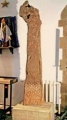
TheCaptain visited on 23rd Apr 2005 - their rating: Cond: 1 Amb: 1 Access: 5 Despite all records stating that this large round tumulus with 8 passage graves is no longer there the remains are quite easy to find within the village. It remains today as a green grassy area within a housing estate surrounded by roads called something like Rue la Tumulus and Rue La Hoguette. There is a large diameter mound with a slight hollow in the middle and remains of some form of signpost.
")
Despite all records stating that this large round tumulus with 8 passage graves is no longer there, the remains are quite easy to find within the village. It remains today as a green grassy area within a housing estate, surrounded by roads called something like Rue la Tumulus and Rue La Hoguette. There is a large diameter mound with a slight hollow in the middle, and remains of some form of signpost.
IMPORTANT NOTE: Positional co-ordinates taken from a gps reciever
You may be viewing yesterday's version of this page. To see the most up to date information please register for a free account.
")
Do not use the above information on other web sites or publications without permission of the contributor.
Nearby Images from Flickr


The above images may not be of the site on this page, but were taken nearby. They are loaded from Flickr so please click on them for image credits.
Click here to see more info for this site
Nearby sites
Click here to view sites on an interactive map of the areaKey: Red: member's photo, Blue: 3rd party photo, Yellow: other image, Green: no photo - please go there and take one, Grey: site destroyed
Download sites to:
KML (Google Earth)
GPX (GPS waypoints)
CSV (Garmin/Navman)
CSV (Excel)
To unlock full downloads you need to sign up as a Contributory Member. Otherwise downloads are limited to 50 sites.
Turn off the page maps and other distractions
Nearby sites listing. In the following links * = Image available
596m W 261° La Hogue* Chambered Tomb
4.5km S 189° Pierre Tournante (Fresnay-le-Puceux)* Standing Stone (Menhir)
6.2km N 354° Fleury-sur-Orne necropolis* Barrow Cemetery
7.5km NNW 332° Menhir dit la Pierre Couchée (Louvigny)* Standing Stone (Menhir)
8.1km SSE 164° Pierre Tourneresse (Gouvix)* Standing Stone (Menhir)
9.9km N 356° Musée de Normandie* Museum
10.5km SE 138° Bretteville-le-Rabet* Ancient Mine, Quarry or other Industry
10.9km W 274° Nécropole mérovingienne à Évrecy* Ancient Village or Settlement
11.4km SSE 167° La Roche Piquée (St-Germain-le-Vasson)* Standing Stone (Menhir)
12.9km NNW 336° Rots necropolis Barrow Cemetery
15.1km NNE 13° Blainville-sur-Orne necropole Barrow Cemetery
16.6km N 10° Les Pierres Branlantes* Chambered Tomb
16.7km NNW 338° Pierre Tourneresse, Cairon* Chambered Tomb
17.1km SE 145° Mont Joly* Ancient Village or Settlement
17.1km SSE 163° Pierre du Pôt* Standing Stone (Menhir)
17.1km SE 146° Bons Tassilly polissoirs* Polissoir
17.5km ESE 110° La Pierre Cornue* Standing Stone (Menhir)
17.5km N 357° Mathieu necropole Barrow Cemetery
17.7km SE 143° Langrais menhirs* Standing Stones
18.2km ESE 115° La Butte du Hu* Chambered Cairn
18.3km ESE 115° Tumuli de Condé-sur-Ifs* Chambered Cairn
18.4km NNW 345° Les Grosses Devises (E)* Standing Stone (Menhir)
18.7km S 169° Menhir dit Pierre de la Hoberie* Standing Stone (Menhir)
18.9km NNW 343° Les Grosses Devises (W)* Standing Stones
19.0km SSE 162° Menhir de la Grurie* Standing Stone (Menhir)
View more nearby sites and additional images


 We would like to know more about this location. Please feel free to add a brief description and any relevant information in your own language.
 Wir möchten mehr über diese Stätte erfahren. Bitte zögern Sie nicht, eine kurze Beschreibung und relevante Informationen in Deutsch hinzuzufügen.
 Nous aimerions en savoir encore un peu sur les lieux. S'il vous plaît n'hesitez pas à ajouter une courte description et tous les renseignements pertinents dans votre propre langue.
 Quisieramos informarnos un poco más de las lugares. No dude en añadir una breve descripción y otros datos relevantes en su propio idioma.