


<< Our Photo Pages >> Dolmen du Bois de la Plesse - Burial Chamber or Dolmen in France in Normandie:Manche (50)
Submitted by TheCaptain on Sunday, 19 December 2004 Page Views: 5103
Neolithic and Bronze AgeSite Name: Dolmen du Bois de la PlesseCountry: France Département: Normandie:Manche (50) Type: Burial Chamber or Dolmen
Nearest Town: La Haye-du-Puits Nearest Village: Lithaire
Latitude: 49.283646N Longitude: 1.492233W
Condition:
| 5 | Perfect |
| 4 | Almost Perfect |
| 3 | Reasonable but with some damage |
| 2 | Ruined but still recognisable as an ancient site |
| 1 | Pretty much destroyed, possibly visible as crop marks |
| 0 | No data. |
| -1 | Completely destroyed |
| 5 | Superb |
| 4 | Good |
| 3 | Ordinary |
| 2 | Not Good |
| 1 | Awful |
| 0 | No data. |
| 5 | Can be driven to, probably with disabled access |
| 4 | Short walk on a footpath |
| 3 | Requiring a bit more of a walk |
| 2 | A long walk |
| 1 | In the middle of nowhere, a nightmare to find |
| 0 | No data. |
| 5 | co-ordinates taken by GPS or official recorded co-ordinates |
| 4 | co-ordinates scaled from a detailed map |
| 3 | co-ordinates scaled from a bad map |
| 2 | co-ordinates of the nearest village |
| 1 | co-ordinates of the nearest town |
| 0 | no data |
Internal Links:
External Links:
I have visited· I would like to visit
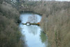
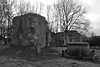
TheCaptain visited on 19th Nov 2004 On the slopes of Mont Castré to the southwest of the village of Lithaire can be found a little leisure park surrounding a quarry with lake. From the car park, cross the lake and climb the steep path to the top of the quarry before following the path around the top to the right through the woods. The monuments are said to have only been discovered in 1965, and with all the other stones laying around in the woods and undergrowth in this area, it wouldn’t surprise me if much more remains to be discovered here. In fact, while walking along the path round the top of the quarry, my eye was caught by an arrangement of large boulders piled on top of each other on a small mound. Having a closer look, I suspect that the large boulders owe more to their current position to relatively modern quarrying than anything ancient, but the mound on which they lie is most interestingly surrounded by what look like very old, carefully placed kerbing stones. I wouldn’t be at all surprised if this is the remains of another Dolmen of some kind.
The coordinates on my GPS (which was slightly misbehaving with low battery power) for this were N 49.28388, W 001.49166 should anyone want a look. Further to the east on Mont Castré are the remains of a Roman encampment, while a bit to the west is a ruined castle, which go to demonstrate the importance of this hill as a place of settlement right through history.
On a further visit here I was not so sure that this was an ancient dolmen this time round, although the circular surrounding stones were still looking like something not natural Perhaps thing as a result of quarrying?
")
On the slopes of Mont Castré southwest of the village of Lithaire is a little leisure park surrounding a quarry with lake. Within this park is an open grassy area within which are the remains of two Allées Couverte.
These monuments are said to have only been discovered in 1965, and with multitudes of other stones laying around in the woods and undergrowth in this area, it wouldn’t surprise me if much more remains to be discovered here.
While walking along the path round the top of the quarry, my eye was caught by an arrangement of large boulders piled on top of each other on a small mound. Having a closer look, I suspect that the large boulders owe more to their current position to relatively modern quarrying than anything ancient, but the mound on which they lie is most interestingly surrounded by what look like very old, carefully placed kerbing stones. I wouldn’t be at all surprised if this is the remains of another Dolmen of some kind.
You may be viewing yesterday's version of this page. To see the most up to date information please register for a free account.
Do not use the above information on other web sites or publications without permission of the contributor.
Nearby Images from Flickr


The above images may not be of the site on this page, but were taken nearby. They are loaded from Flickr so please click on them for image credits.
Click here to see more info for this site
Nearby sites
Click here to view sites on an interactive map of the areaKey: Red: member's photo, Blue: 3rd party photo, Yellow: other image, Green: no photo - please go there and take one, Grey: site destroyed
Download sites to:
KML (Google Earth)
GPX (GPS waypoints)
CSV (Garmin/Navman)
CSV (Excel)
To unlock full downloads you need to sign up as a Contributory Member. Otherwise downloads are limited to 50 sites.
Turn off the page maps and other distractions
Nearby sites listing. In the following links * = Image available
321m NW 313° Allée couverte du Bois de la Plesse (Sud)* Passage Grave
324m NW 315° Allée couverte du Bois de la Plesse (Nord)* Passage Grave
972m WSW 252° Bois du Mont* Passage Grave
9.0km NE 50° Dolmen du Champ de la Pierre Burial Chamber or Dolmen
10.0km N 10° Pierre Butée* Standing Stone (Menhir)
10.2km S 173° Millières menhir* Standing Stone (Menhir)
11.8km ENE 64° Pierre Lée (Appeville) Burial Chamber or Dolmen
12.6km WNW 282° Pierre à l'Homme Standing Stone (Menhir)
17.3km SSW 193° Droits a l'Homme* Modern Stone Circle etc
17.7km SSW 196° Geffosses Ecole-des-Filles* Standing Stone (Menhir)
18.8km NE 42° Ste-Mère-Eglise Borne Gallo/Roman* Marker Stone
19.2km SSW 196° L'Oeuf de Gargantua* Standing Stone (Menhir)
19.6km ENE 65° Tumulus de Vierville* Chambered Tomb
21.1km NW 305° Allée Couverte d'Haye d'Ectot* Passage Grave
21.9km SSW 196° Menhir de Gouville* Standing Stone (Menhir)
22.3km S 184° Pierre de Mélier Standing Stone (Menhir)
22.7km SSW 195° Gouville-sur-Mer Menhir* Standing Stone (Menhir)
23.2km NW 308° Autel des Druides des Moitiers d'Allonne* Passage Grave
23.5km N 350° Pierre Dressée (Nègreville) Standing Stone (Menhir)
23.9km NNW 344° Table des Fées (Rocheville)* Passage Grave
24.5km NNW 343° Petite Roche allée couverte* Passage Grave
24.6km NNW 344° Allée Couverte de Câtillon Passage Grave
25.1km SSW 195° Menhir de Blainville-sur-Mer* Standing Stone (Menhir)
25.2km S 189° St-Malo-de-la-Lande menhir* Standing Stone (Menhir)
25.5km NNW 346° Galerie des Forges Passage Grave
View more nearby sites and additional images


 We would like to know more about this location. Please feel free to add a brief description and any relevant information in your own language.
 Wir möchten mehr über diese Stätte erfahren. Bitte zögern Sie nicht, eine kurze Beschreibung und relevante Informationen in Deutsch hinzuzufügen.
 Nous aimerions en savoir encore un peu sur les lieux. S'il vous plaît n'hesitez pas à ajouter une courte description et tous les renseignements pertinents dans votre propre langue.
 Quisieramos informarnos un poco más de las lugares. No dude en añadir una breve descripción y otros datos relevantes en su propio idioma.