 with our Megalithic Portal iPhone app")


<< Our Photo Pages >> Broadbank - Ancient Village or Settlement in England in Lancashire
Submitted by treehugger on Tuesday, 16 February 2016 Page Views: 8774
Multi-periodSite Name: Broadbank Alternative Name: Burwains Enclosure; Burwains CampCountry: England County: Lancashire Type: Ancient Village or Settlement
Nearest Town: Burnley Nearest Village: Thursden
Map Ref: SD9023935227 Landranger Map Number: 103
Latitude: 53.813234N Longitude: 2.149725W
Condition:
| 5 | Perfect |
| 4 | Almost Perfect |
| 3 | Reasonable but with some damage |
| 2 | Ruined but still recognisable as an ancient site |
| 1 | Pretty much destroyed, possibly visible as crop marks |
| 0 | No data. |
| -1 | Completely destroyed |
| 5 | Superb |
| 4 | Good |
| 3 | Ordinary |
| 2 | Not Good |
| 1 | Awful |
| 0 | No data. |
| 5 | Can be driven to, probably with disabled access |
| 4 | Short walk on a footpath |
| 3 | Requiring a bit more of a walk |
| 2 | A long walk |
| 1 | In the middle of nowhere, a nightmare to find |
| 0 | No data. |
| 5 | co-ordinates taken by GPS or official recorded co-ordinates |
| 4 | co-ordinates scaled from a detailed map |
| 3 | co-ordinates scaled from a bad map |
| 2 | co-ordinates of the nearest village |
| 1 | co-ordinates of the nearest town |
| 0 | no data |
Internal Links:
External Links:
I have visited· I would like to visit
SumDoood would like to visit
")
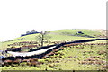
Treehugger wrote in 2004: it is a 'henge like' structure - there is also the remains of a stone circle in this field which I have been told is Burwains Farm Stone Circle. Can anyone shed light on this? [Note April 2017: see comments below for more information].
This circular hill top enclosure is recorded as Pastscape Monument No. 46151, the latest entry of which is from 1975 and tells us the camp was possibly unfinished. The site is also scheduled as Historic England List ID 1013814, which tells us this is: "(a) prehistoric defended settlement. It is located on a hilltop on the northern side of the steep-sided Thursden Valley and includes a circular enclosure surrounded by an inner ditch and an outer bank. The enclosure measures approximately 45m in diameter, the ditch measures c.0.3m wide by 0.25m deep, and the outer bank measures c.2m wide and up to 0.3m high. There are opposed entrances through the bank and across the ditch on the west and east sides".
The Journal of Antiquities also includes an entry for the Broadbank Earth Circle/Enclosure, Briercliffe, Lancashire, which includes directions for finding this enclosure, together with photographs, background information and a list of reference sources for more information.
You may be viewing yesterday's version of this page. To see the most up to date information please register for a free account.
")
")
")
Do not use the above information on other web sites or publications without permission of the contributor.
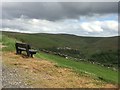
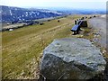
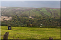
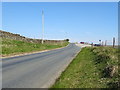
Nearby Images from Geograph Britain and Ireland:
©2015(licence)
©2013(licence)
©2016(licence)
©2019(licence)
©2009(licence)
The above images may not be of the site on this page, they are loaded from Geograph.
Please Submit an Image of this site or go out and take one for us!
Click here to see more info for this site
Nearby sites
Key: Red: member's photo, Blue: 3rd party photo, Yellow: other image, Green: no photo - please go there and take one, Grey: site destroyed
Download sites to:
KML (Google Earth)
GPX (GPS waypoints)
CSV (Garmin/Navman)
CSV (Excel)
To unlock full downloads you need to sign up as a Contributory Member. Otherwise downloads are limited to 50 sites.
Turn off the page maps and other distractions
Nearby sites listing. In the following links * = Image available
294m NW 306° Burwain's Camp* Misc. Earthwork (SD900354)
1.1km S 186° Hellclough Ring Cairn* Cairn (SD9012534145)
1.1km S 182° Hellclough Saucer Barrow* Ring Cairn (SD9020034124)
1.2km SW 222° Bonfire Hill 1* Cairn (SD894343)
1.5km S 187° Delf Hill* Stone Circle (SD9006433732)
1.5km SW 222° Bonfire Hill II* Round Barrow(s) (SD892341)
1.5km WNW 292° Burwain's Farm Stone Circle (SD888358)
1.6km SW 225° Bonfire Hill III* Round Barrow(s) (SD891341)
1.7km SW 227° Beadle Hill (Extwistle) Misc. Earthwork (SD8901834112)
1.9km NNW 341° Knave Hill (Nelson)* Cairn (SD8963636991)
1.9km SW 227° Beth Cross (Holden Clough) Ancient Cross (SD88863395)
2.0km NNW 330° Ring Stones Hill Stone Circle (SD89263693)
2.0km SW 219° Twist Hill Barrow* Round Barrow(s) (SD88983370)
2.1km W 272° Annot Cross (Brierfield) Ancient Cross (SD881353)
2.2km WSW 239° Nogworth Cross (Briercliffe) Ancient Cross (SD8833934086)
2.3km NNW 339° Walton Spire Cross* Standing Stone (Menhir) (SD8941637328)
2.4km WSW 255° Calf Hey Well (Briercliffe) Holy Well or Sacred Spring (SD8794334622)
2.4km NNW 339° Walton Spire Stone* Standing Stone (Menhir) (SD8939137498)
2.7km SW 215° Ring Stones (Worsthorne) Stone Circle (SD8864933006)
2.8km ESE 122° Grey Stone Hill* Rock Art (SD9259433766)
2.8km SSW 203° Hameldon Pasture (I)* Round Barrow(s) (SD8914232622)
2.8km NW 313° Catlow Well/Spring* Holy Well or Sacred Spring (SD8818137169)
2.9km SSW 203° Hameldon Pasture (II)* Cairn (SD8911832597)
3.0km SW 216° Worsthorne Moor* Stone Circle (SD8845932764)
3.1km E 98° Dove Stones (Widdop Moor)* Natural Stone / Erratic / Other Natural Feature (SD93333479)
View more nearby sites and additional images


 We would like to know more about this location. Please feel free to add a brief description and any relevant information in your own language.
 Wir möchten mehr über diese Stätte erfahren. Bitte zögern Sie nicht, eine kurze Beschreibung und relevante Informationen in Deutsch hinzuzufügen.
 Nous aimerions en savoir encore un peu sur les lieux. S'il vous plaît n'hesitez pas à ajouter une courte description et tous les renseignements pertinents dans votre propre langue.
 Quisieramos informarnos un poco más de las lugares. No dude en añadir una breve descripción y otros datos relevantes en su propio idioma.