


<< Our Photo Pages >> Formaston - Class II Pictish Symbol Stone in Scotland in Aberdeenshire
Submitted by ENorn on Thursday, 26 February 2004 Page Views: 9212
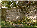
Early Medieval (Dark Age)Site Name: Formaston Alternative Name: Aboyne Cross Slab, St. Adamnan's ChurchCountry: Scotland County: Aberdeenshire Type: Class II Pictish Symbol Stone
Map Ref: NJ541001 Landranger Map Number: 37
Latitude: 57.089592N Longitude: 2.759022W
Condition:
| 5 | Perfect |
| 4 | Almost Perfect |
| 3 | Reasonable but with some damage |
| 2 | Ruined but still recognisable as an ancient site |
| 1 | Pretty much destroyed, possibly visible as crop marks |
| 0 | No data. |
| -1 | Completely destroyed |
| 5 | Superb |
| 4 | Good |
| 3 | Ordinary |
| 2 | Not Good |
| 1 | Awful |
| 0 | No data. |
| 5 | Can be driven to, probably with disabled access |
| 4 | Short walk on a footpath |
| 3 | Requiring a bit more of a walk |
| 2 | A long walk |
| 1 | In the middle of nowhere, a nightmare to find |
| 0 | No data. |
| 5 | co-ordinates taken by GPS or official recorded co-ordinates |
| 4 | co-ordinates scaled from a detailed map |
| 3 | co-ordinates scaled from a bad map |
| 2 | co-ordinates of the nearest village |
| 1 | co-ordinates of the nearest town |
| 0 | no data |
Internal Links:
External Links:
")
Formaston, Aboyne, Aberdeenshire NJ05SW 1; Class 2 (fragment); Ogham on front face about half way up the right hand side, transliterated as “MAQQOoiTALLUORRH | NxHHTVROBBACCxNNEVV”.
Ogham characters are on two parallel artificial stem-lines.
You may be viewing yesterday's version of this page. To see the most up to date information please register for a free account.
")
")
")
Do not use the above information on other web sites or publications without permission of the contributor.
Nearby Images from Geograph Britain and Ireland:
©2006(licence)
©2007(licence)
©2007(licence)
©2020(licence)
©2007(licence)
The above images may not be of the site on this page, they are loaded from Geograph.
Please Submit an Image of this site or go out and take one for us!
Click here to see more info for this site
Nearby sites
Key: Red: member's photo, Blue: 3rd party photo, Yellow: other image, Green: no photo - please go there and take one, Grey: site destroyed
Download sites to:
KML (Google Earth)
GPX (GPS waypoints)
CSV (Garmin/Navman)
CSV (Excel)
To unlock full downloads you need to sign up as a Contributory Member. Otherwise downloads are limited to 50 sites.
Turn off the page maps and other distractions
Nearby sites listing. In the following links * = Image available
1.1km WSW 243° Lady Well (Aboyne)* Holy Well or Sacred Spring (NO531996)
1.4km E 100° Dess Stone Circle* Modern Stone Circle etc (NO55449985)
2.0km WSW 236° Image Wood* Stone Circle (NO524990)
2.3km SSW 199° Waterside Hut Circles Ancient Village or Settlement (NO533979)
3.1km SSE 153° Birse* Class I Pictish Symbol Stone (NO555973)
5.0km W 275° Blue Cairn (Cairn)* Cairn (NJ49070059)
5.1km E 94° St Erchan's Well* Holy Well or Sacred Spring (NO592997)
5.3km WNW 303° North Gellan Ancient Village or Settlement (NJ497030)
5.6km ENE 58° Cairn Mude* Cairn (NJ58870301)
5.8km WSW 254° Ferrar Ancient Village or Settlement (NO485986)
6.3km W 276° Balnacraig Cairn Aberdeenshire Chambered Cairn (NJ47830082)
6.4km NE 35° Macbeth's Cairn* Cairn (NJ578053)
6.4km WNW 301° Tomnaverie* Stone Circle (NJ48650348)
6.5km NW 326° Culsh* Souterrain (Fogou, Earth House) (NJ5048305488)
7.1km ENE 60° Balnacraig Stone Circle* Stone Circle (NJ60330353)
7.1km SE 138° Berrysloch* Standing Stone (Menhir) (NO588947)
7.6km W 269° Knockenzie Ancient Village or Settlement (NJ465000)
7.8km NNW 334° Hillhead Stone Circle Stone Circle (NJ50720714)
8.0km ESE 120° Inchbaire Stone Circle (NO610960)
8.1km NW 307° Waulkmill* Stone Circle (NJ47630500)
8.1km SE 141° Finzean House* Chambered Cairn (NO591937)
8.1km SE 138° Dardannus Stone* Standing Stone (Menhir) (NO595940)
8.2km SE 137° Corsedardar* Standing Stone (Menhir) (NO59709405)
8.5km NW 313° Doune Hill Stone Circle (NJ480060)
8.6km NW 305° Melgum Centre* Stone Circle (NJ471052)
View more nearby sites and additional images


 We would like to know more about this location. Please feel free to add a brief description and any relevant information in your own language.
 Wir möchten mehr über diese Stätte erfahren. Bitte zögern Sie nicht, eine kurze Beschreibung und relevante Informationen in Deutsch hinzuzufügen.
 Nous aimerions en savoir encore un peu sur les lieux. S'il vous plaît n'hesitez pas à ajouter une courte description et tous les renseignements pertinents dans votre propre langue.
 Quisieramos informarnos un poco más de las lugares. No dude en añadir una breve descripción y otros datos relevantes en su propio idioma.