

<< Our Photo Pages >> Sepulture Bois Noirs - Burial Chamber or Dolmen in France in Pays de la Loire:Maine-et-Loire 49
Submitted by TheCaptain on Friday, 06 May 2011 Page Views: 1845
Neolithic and Bronze AgeSite Name: Sepulture Bois NoirsCountry: France Département: Pays de la Loire:Maine-et-Loire 49 Type: Burial Chamber or Dolmen
Nearest Town: Angers Nearest Village: Meon
Latitude: 47.462900N Longitude: 0.101200E
Condition:
| 5 | Perfect |
| 4 | Almost Perfect |
| 3 | Reasonable but with some damage |
| 2 | Ruined but still recognisable as an ancient site |
| 1 | Pretty much destroyed, possibly visible as crop marks |
| 0 | No data. |
| -1 | Completely destroyed |
| 5 | Superb |
| 4 | Good |
| 3 | Ordinary |
| 2 | Not Good |
| 1 | Awful |
| 0 | No data. |
| 5 | Can be driven to, probably with disabled access |
| 4 | Short walk on a footpath |
| 3 | Requiring a bit more of a walk |
| 2 | A long walk |
| 1 | In the middle of nowhere, a nightmare to find |
| 0 | No data. |
| 5 | co-ordinates taken by GPS or official recorded co-ordinates |
| 4 | co-ordinates scaled from a detailed map |
| 3 | co-ordinates scaled from a bad map |
| 2 | co-ordinates of the nearest village |
| 1 | co-ordinates of the nearest town |
| 0 | no data |
Be the first person to rate this site - see the 'Contribute!' box in the right hand menu.
Internal Links:
External Links:
I have visited· I would like to visit
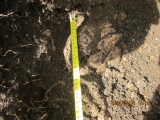
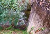
Silver1 visited on 1st Apr 2016 - their rating: Cond: 3 Amb: 3 Access: 1 We have a house nearby and even with the coordinates giving us an idea of where it was it took several visits over a couple of years to find! Don't try it during the summer or autumnas the bracken is too high and the undergrowth too thick. Best approach is from the field track to the south. Turn N off this track when you get to the tallest tree - it is obvious when you get there - and march straight in due noirth. The dolmen is all but buried with the capstone just above ground level but is recogniseable for what it is. Tip: Start looking for the alignment Bois Noir (adjacent to it) once you have located the sepulchre Bois Noir - it made the search easier for us as there are numerous stone outcrops that you can spend hours scratching your head about!.
")
You may be viewing yesterday's version of this page. To see the most up to date information please register for a free account.
")
")
Do not use the above information on other web sites or publications without permission of the contributor.
Nearby Images from Flickr

The above images may not be of the site on this page, but were taken nearby. They are loaded from Flickr so please click on them for image credits.
Click here to see more info for this site
Nearby sites
Click here to view sites on an interactive map of the areaKey: Red: member's photo, Blue: 3rd party photo, Yellow: other image, Green: no photo - please go there and take one, Grey: site destroyed
Download sites to:
KML (Google Earth)
GPX (GPS waypoints)
CSV (Garmin/Navman)
CSV (Excel)
To unlock full downloads you need to sign up as a Contributory Member. Otherwise downloads are limited to 50 sites.
Turn off the page maps and other distractions
Nearby sites listing. In the following links * = Image available
793m ENE 75° Alignement Bois Noirs* Stone Row / Alignment
8.1km SSE 162° Pierre Posée du Chateau Burial Chamber or Dolmen
8.3km ESE 112° Alignement dit les Trois Chiens Stone Row / Alignment
9.1km SSE 147° Menhir de la Délugrie* Standing Stone (Menhir)
9.5km SE 144° Dolmen de La Roche Meon Burial Chamber or Dolmen
9.5km ESE 117° Menhir de La Besselière Standing Stone (Menhir)
10.6km SE 138° Menhir de La Garenne Standing Stone (Menhir)
11.1km E 98° La Pierre Saint Urbain Standing Stone (Menhir)
11.9km SE 134° Continvoir Dolmen* Burial Chamber or Dolmen
12.0km SE 135° Cromlech de Continvoir* Stone Circle
12.6km NW 310° Sepulture du Grand Trouvé Burial Chamber or Dolmen
12.9km NNE 22° Dolmen de Bareil Burial Chamber or Dolmen
12.9km W 276° Pierre-Fritte (Cuon) Standing Stone (Menhir)
12.9km NE 45° Dolmen de la Bénardière Burial Chamber or Dolmen
13.1km WNW 288° Pierre du Guedeniau Standing Stone (Menhir)
13.1km S 180° La Mere Michel Standing Stone (Menhir)
13.5km NNE 24° Dolmen de Chantepierre Burial Chamber or Dolmen
13.6km NNE 17° La Pierre Couverte de la Planche* Burial Chamber or Dolmen
13.8km NW 312° Pierre du Géant (Pontigné) Standing Stone (Menhir)
13.8km NNE 12° Dolmen de Laurière Burial Chamber or Dolmen
14.0km NNE 12° L'Aurière menhir Standing Stone (Menhir)
15.7km NNE 25° Dolmen du Moulin à Vent Burial Chamber or Dolmen
16.2km NW 307° Pierre Couverte (Pontigné)* Passage Grave
16.4km NW 307° Polissoir de la Motte Polissoir
16.4km NW 308° Menhir de la Motte Standing Stone (Menhir)
View more nearby sites and additional images


 We would like to know more about this location. Please feel free to add a brief description and any relevant information in your own language.
 Wir möchten mehr über diese Stätte erfahren. Bitte zögern Sie nicht, eine kurze Beschreibung und relevante Informationen in Deutsch hinzuzufügen.
 Nous aimerions en savoir encore un peu sur les lieux. S'il vous plaît n'hesitez pas à ajouter une courte description et tous les renseignements pertinents dans votre propre langue.
 Quisieramos informarnos un poco más de las lugares. No dude en añadir una breve descripción y otros datos relevantes en su propio idioma.