


<< Our Photo Pages >> Dolmen de la Prade (Allenc) - Burial Chamber or Dolmen in France in Languedoc:Lozère (48)
Submitted by TheCaptain on Friday, 06 May 2011 Page Views: 2282
Neolithic and Bronze AgeSite Name: Dolmen de la Prade (Allenc) Alternative Name: Lo Liech dau GeïonCountry: France Département: Languedoc:Lozère (48) Type: Burial Chamber or Dolmen
Nearest Town: Mende Nearest Village: Allenc
Latitude: 44.570316N Longitude: 3.678449E
Condition:
| 5 | Perfect |
| 4 | Almost Perfect |
| 3 | Reasonable but with some damage |
| 2 | Ruined but still recognisable as an ancient site |
| 1 | Pretty much destroyed, possibly visible as crop marks |
| 0 | No data. |
| -1 | Completely destroyed |
| 5 | Superb |
| 4 | Good |
| 3 | Ordinary |
| 2 | Not Good |
| 1 | Awful |
| 0 | No data. |
| 5 | Can be driven to, probably with disabled access |
| 4 | Short walk on a footpath |
| 3 | Requiring a bit more of a walk |
| 2 | A long walk |
| 1 | In the middle of nowhere, a nightmare to find |
| 0 | No data. |
| 5 | co-ordinates taken by GPS or official recorded co-ordinates |
| 4 | co-ordinates scaled from a detailed map |
| 3 | co-ordinates scaled from a bad map |
| 2 | co-ordinates of the nearest village |
| 1 | co-ordinates of the nearest town |
| 0 | no data |
Internal Links:
External Links:
I have visited· I would like to visit
johnstone visited on 11th Jul 2007 - their rating: Cond: 2 Amb: 4 Access: 4
 (PID:34537)")
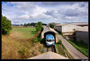
Dolmen de la Prade is a burial chamber in the community of Allenc, Departement of Lozere, Region of Languedoc-Rousillon
Location Source: T4T35.fr
You may be viewing yesterday's version of this page. To see the most up to date information please register for a free account.
 (PID:187581)")
 (PID:187580)")
Do not use the above information on other web sites or publications without permission of the contributor.
Nearby Images from Flickr

The above images may not be of the site on this page, but were taken nearby. They are loaded from Flickr so please click on them for image credits.
Click here to see more info for this site
Nearby sites
Click here to view sites on an interactive map of the areaKey: Red: member's photo, Blue: 3rd party photo, Yellow: other image, Green: no photo - please go there and take one, Grey: site destroyed
Download sites to:
KML (Google Earth)
GPX (GPS waypoints)
CSV (Garmin/Navman)
CSV (Excel)
To unlock full downloads you need to sign up as a Contributory Member. Otherwise downloads are limited to 50 sites.
Turn off the page maps and other distractions
Nearby sites listing. In the following links * = Image available
1.5km NW 309° Menhir de Laubert* Standing Stone (Menhir)
2.5km NW 321° Menhir du Col de la Pierre Plantée (Laubert)* Modern Stone Circle etc
3.0km NE 42° Menhir de Montbel* Standing Stone (Menhir)
4.8km ESE 122° Menhir dit la Pierre Plantée (Allenc)* Standing Stone (Menhir)
6.0km NW 311° Dolmen du Chapel Burial Chamber or Dolmen
6.1km W 277° Dolmen de la Tailladisse* Burial Chamber or Dolmen
6.6km NW 321° Menhir du Plot de la Fage 4* Standing Stone (Menhir)
7.4km NW 312° Menhir du Plot de la Fage 1* Standing Stone (Menhir)
7.4km NW 313° Menhir du Plot de la Fage 5* Standing Stone (Menhir)
7.4km NW 314° Menhir du Plot de la Fage 3* Standing Stone (Menhir)
7.4km NW 314° Menhir du Plot de la Fage 2* Standing Stone (Menhir)
8.4km S 187° Menhir de la Fergère* Standing Stone (Menhir)
8.5km SSW 199° Menhir de l'Oustel-Cremat* Standing Stone (Menhir)
8.5km WSW 246° Dolmen de la Rouvière (Pelouse) Burial Chamber or Dolmen
9.3km W 263° Dolmen du Féron Burial Chamber or Dolmen
9.4km S 173° Menhir de Cheyroux* Standing Stone (Menhir)
10.4km ENE 62° Pascalou Menhir* Standing Stone (Menhir)
11.5km SW 227° Mausoleum Lanuéjols* Ancient Temple
11.7km SSW 205° Menhir de Brajon Standing Stone (Menhir)
12.7km SW 228° Menhir du Boy* Standing Stone (Menhir)
13.6km SW 223° Dolmen de la Blachère Burial Chamber or Dolmen
14.9km NNE 13° Menhir de Pierrefiche (Mende)* Standing Stone (Menhir)
17.3km SSW 205° Menhir de la Borie 2 Standing Stone (Menhir)
17.6km SSW 192° Menhir dit de la Maisonnette 1* Standing Stone (Menhir)
17.7km SSW 192° Menhirs dit de la Maisonnette 2* Standing Stone (Menhir)
View more nearby sites and additional images


 We would like to know more about this location. Please feel free to add a brief description and any relevant information in your own language.
 Wir möchten mehr über diese Stätte erfahren. Bitte zögern Sie nicht, eine kurze Beschreibung und relevante Informationen in Deutsch hinzuzufügen.
 Nous aimerions en savoir encore un peu sur les lieux. S'il vous plaît n'hesitez pas à ajouter une courte description et tous les renseignements pertinents dans votre propre langue.
 Quisieramos informarnos un poco más de las lugares. No dude en añadir una breve descripción y otros datos relevantes en su propio idioma.