

<< Our Photo Pages >> Féchain Polissoir - Polissoir in France in Nord:Nord (59)
Submitted by AlexHunger on Tuesday, 17 May 2005 Page Views: 4085
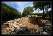
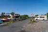
Neolithic and Bronze AgeSite Name: Féchain PolissoirCountry: France Département: Nord:Nord (59) Type: Polissoir
Nearest Town: Arras Nearest Village: Féchain
Latitude: 50.265787N Longitude: 3.211926E
Condition:
| 5 | Perfect |
| 4 | Almost Perfect |
| 3 | Reasonable but with some damage |
| 2 | Ruined but still recognisable as an ancient site |
| 1 | Pretty much destroyed, possibly visible as crop marks |
| 0 | No data. |
| -1 | Completely destroyed |
| 5 | Superb |
| 4 | Good |
| 3 | Ordinary |
| 2 | Not Good |
| 1 | Awful |
| 0 | No data. |
| 5 | Can be driven to, probably with disabled access |
| 4 | Short walk on a footpath |
| 3 | Requiring a bit more of a walk |
| 2 | A long walk |
| 1 | In the middle of nowhere, a nightmare to find |
| 0 | No data. |
| 5 | co-ordinates taken by GPS or official recorded co-ordinates |
| 4 | co-ordinates scaled from a detailed map |
| 3 | co-ordinates scaled from a bad map |
| 2 | co-ordinates of the nearest village |
| 1 | co-ordinates of the nearest town |
| 0 | no data |
Internal Links:
External Links:
")
1.10 metres tall and 1.70 metres long with marks. Grey Limestone. In front of church.
Address: Rue Louis Chantreau.
You may be viewing yesterday's version of this page. To see the most up to date information please register for a free account.
")
Do not use the above information on other web sites or publications without permission of the contributor.
davidmorgan has found this location on Google Street View:
Nearby Images from Flickr


The above images may not be of the site on this page, but were taken nearby. They are loaded from Flickr so please click on them for image credits.
Click here to see more info for this site
Nearby sites
Click here to view sites on an interactive map of the areaKey: Red: member's photo, Blue: 3rd party photo, Yellow: other image, Green: no photo - please go there and take one, Grey: site destroyed
Download sites to:
KML (Google Earth)
GPX (GPS waypoints)
CSV (Garmin/Navman)
CSV (Excel)
To unlock full downloads you need to sign up as a Contributory Member. Otherwise downloads are limited to 50 sites.
Turn off the page maps and other distractions
Nearby sites listing. In the following links * = Image available
4.7km W 272° La-Pierre-qui-Pousse (Aubigny-au-Bac)* Standing Stone (Menhir)
5.8km NNW 330° Menhir dit la Borne-Grand-Père* Marker Stone
8.0km W 272° Palluel Menhir Statue* Standing Stone (Menhir)
8.5km W 261° Le Gros Caillou (Oisy-le-Verger)* Standing Stone (Menhir)
9.9km SSE 166° Pierres Jumelles (Cambrai)* Standing Stone (Menhir)
11.2km W 280° Dolmen dit les Pierres Chavattes* Burial Chamber or Dolmen
13.2km SSE 168° Cromlech de Niergnies* Stone Circle
13.2km W 272° La Pierre du Diable (Lécluse)* Standing Stone (Menhir)
16.9km W 274° Cromlech dit Les-Sept-Bonnettes* Stone Circle
17.0km NNW 340° Douai Musée d'Archéologie* Museum
21.0km E 89° Menhir dit le Gros Caillou* Standing Stone (Menhir)
25.0km SSE 148° Menhir de Clary* Standing Stone (Menhir)
32.0km ESE 118° Le-Polissoir-d'Ors* Standing Stone (Menhir)
32.2km NW 314° Tombe de Pont-a-Vendin Burial Chamber or Dolmen
32.3km NNE 26° Brunehault* Standing Stone (Menhir)
36.8km N 356° Mont des Tombes Hillfort
38.3km NNE 27° Tumulus du Trou de Billemont* Artificial Mound
38.8km NE 52° Bernissart, Jardin Géologique* Museum
39.1km WNW 284° Les Pierres Jumelles (Mont-Saint-Éloi)* Standing Stones
39.9km NNE 18° Musée archéologique de Tournai* Museum
40.1km E 80° Menhir dit la Pierre Croûte* Standing Stone (Menhir)
41.3km E 85° Bavay Musée Archéologique* Museum
41.9km SSW 205° Le Doigt de Gargantua (Doingt)* Standing Stone (Menhir)
46.1km WNW 292° Dolmen dit la Table des Fées* Burial Chamber or Dolmen
47.4km NE 43° Archéosite* Museum
View more nearby sites and additional images


 We would like to know more about this location. Please feel free to add a brief description and any relevant information in your own language.
 Wir möchten mehr über diese Stätte erfahren. Bitte zögern Sie nicht, eine kurze Beschreibung und relevante Informationen in Deutsch hinzuzufügen.
 Nous aimerions en savoir encore un peu sur les lieux. S'il vous plaît n'hesitez pas à ajouter une courte description et tous les renseignements pertinents dans votre propre langue.
 Quisieramos informarnos un poco más de las lugares. No dude en añadir una breve descripción y otros datos relevantes en su propio idioma.