 with our Megalithic Portal iPhone app")


<< Our Photo Pages >> Roc de l'Oie - Rock Outcrop in France in Midi:Tarn (81)
Submitted by TheCaptain on Saturday, 16 April 2005 Page Views: 2830
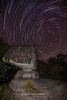
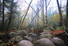
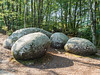
Natural PlacesSite Name: Roc de l'Oie Alternative Name: SidobreCountry: France Département: Midi:Tarn (81) Type: Rock Outcrop
Nearest Town: Castres Nearest Village: Lacrouzette
Latitude: 43.668332N Longitude: 2.389586E
Condition:
| 5 | Perfect |
| 4 | Almost Perfect |
| 3 | Reasonable but with some damage |
| 2 | Ruined but still recognisable as an ancient site |
| 1 | Pretty much destroyed, possibly visible as crop marks |
| 0 | No data. |
| -1 | Completely destroyed |
| 5 | Superb |
| 4 | Good |
| 3 | Ordinary |
| 2 | Not Good |
| 1 | Awful |
| 0 | No data. |
| 5 | Can be driven to, probably with disabled access |
| 4 | Short walk on a footpath |
| 3 | Requiring a bit more of a walk |
| 2 | A long walk |
| 1 | In the middle of nowhere, a nightmare to find |
| 0 | No data. |
| 5 | co-ordinates taken by GPS or official recorded co-ordinates |
| 4 | co-ordinates scaled from a detailed map |
| 3 | co-ordinates scaled from a bad map |
| 2 | co-ordinates of the nearest village |
| 1 | co-ordinates of the nearest town |
| 0 | no data |
Internal Links:
External Links:
I have visited· I would like to visit
johnstone visited on 12th Sep 2018 - their rating: Cond: 4 Amb: 4 Access: 3
TheCaptain visited on 24th Sep 2000 - their rating: Cond: 4 Amb: 4 Access: 3 Celebrated rock shaped like a goose, in the Sidobre region to the east of Castres.
Average ratings for this site from all visit loggers: Condition: 4 Ambience: 4 Access: 3
")
Part of the “Sentier des Merveilles”, a walking tour between Crémaussel and Ricard, also belonging to the GR36
Roc de l'Oie, Chemin de Lacrouzette à Cros, Caminade, Lacrouzette, Castres, Tarn, Midi-Pyrénées
Location Source: OpenStreetMap
You may be viewing yesterday's version of this page. To see the most up to date information please register for a free account.
")
")
")
Do not use the above information on other web sites or publications without permission of the contributor.
Nearby Images from Flickr
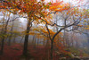
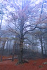
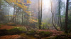
The above images may not be of the site on this page, but were taken nearby. They are loaded from Flickr so please click on them for image credits.
Click here to see more info for this site
Nearby sites
Click here to view sites on an interactive map of the areaKey: Red: member's photo, Blue: 3rd party photo, Yellow: other image, Green: no photo - please go there and take one, Grey: site destroyed
Download sites to:
KML (Google Earth)
GPX (GPS waypoints)
CSV (Garmin/Navman)
CSV (Excel)
To unlock full downloads you need to sign up as a Contributory Member. Otherwise downloads are limited to 50 sites.
Turn off the page maps and other distractions
Nearby sites listing. In the following links * = Image available
142m ENE 65° Le Billard* Rock Outcrop
207m ENE 60° L'Eléphant* Rock Outcrop
258m ESE 105° Roc Le Fauteuil* Rock Outcrop
268m ENE 69° Le Fauteuil du Diable* Rock Outcrop
289m ENE 65° La Balme de l’Empreinte* Rock Outcrop
309m NNW 327° Les Trois Fromages* Rock Outcrop
337m ENE 62° Le Mur de la Mort* Rock Outcrop
413m ENE 68° Le Squale* Rock Outcrop
479m ESE 110° Les Roches Décalées* Rock Outcrop
517m E 91° Le Corridor Rock Outcrop
712m W 262° Le Chapeau du Curé* Rock Outcrop
2.1km SSW 213° Le Chaos de la Resse* Rock Outcrop
2.2km WSW 246° Peyro Clabado* Rock Outcrop
2.3km S 181° Le Roc de l'Escargot* Rock Outcrop
2.9km ESE 112° Sécun statue-menhir* Sculptured Stone
3.0km WSW 246° Le Rocher Tremblant de la Barque* Rock Outcrop
3.3km ESE 121° Montjarié menhir 2 Standing Stone (Menhir)
3.4km SE 135° Statue Menhir de La Baïssas* Sculptured Stone
3.9km S 178° Rocher Tremblant de Sept Faux* Rock Outcrop
4.0km SW 226° Le Roc du Verdier* Rock Outcrop
4.1km SSE 159° Menhir de la Maison du Sidobre* Modern Stone Circle etc
5.3km SE 140° Guior-Haut statue-menhir* Sculptured Stone
5.6km SE 143° Croix-de-Guior menhir* Sculptured Stone
5.7km SSE 163° Le Roc de l'Enclume* Rock Outcrop
5.7km SE 143° Montjarié menhir 1* Standing Stone (Menhir)
View more nearby sites and additional images


 We would like to know more about this location. Please feel free to add a brief description and any relevant information in your own language.
 Wir möchten mehr über diese Stätte erfahren. Bitte zögern Sie nicht, eine kurze Beschreibung und relevante Informationen in Deutsch hinzuzufügen.
 Nous aimerions en savoir encore un peu sur les lieux. S'il vous plaît n'hesitez pas à ajouter une courte description et tous les renseignements pertinents dans votre propre langue.
 Quisieramos informarnos un poco más de las lugares. No dude en añadir una breve descripción y otros datos relevantes en su propio idioma.