


<< Text Pages >> Grotte de Miers - Cave or Rock Shelter in France in Midi:Lot (46)
Submitted by TheCaptain on Saturday, 16 April 2005 Page Views: 2043
Natural PlacesSite Name: Grotte de MiersCountry: France Département: Midi:Lot (46) Type: Cave or Rock Shelter
Nearest Town: Souillac Nearest Village: Miers
Latitude: 44.854000N Longitude: 1.726000E
Condition:
| 5 | Perfect |
| 4 | Almost Perfect |
| 3 | Reasonable but with some damage |
| 2 | Ruined but still recognisable as an ancient site |
| 1 | Pretty much destroyed, possibly visible as crop marks |
| 0 | No data. |
| -1 | Completely destroyed |
| 5 | Superb |
| 4 | Good |
| 3 | Ordinary |
| 2 | Not Good |
| 1 | Awful |
| 0 | No data. |
| 5 | Can be driven to, probably with disabled access |
| 4 | Short walk on a footpath |
| 3 | Requiring a bit more of a walk |
| 2 | A long walk |
| 1 | In the middle of nowhere, a nightmare to find |
| 0 | No data. |
| 5 | co-ordinates taken by GPS or official recorded co-ordinates |
| 4 | co-ordinates scaled from a detailed map |
| 3 | co-ordinates scaled from a bad map |
| 2 | co-ordinates of the nearest village |
| 1 | co-ordinates of the nearest town |
| 0 | no data |
Be the first person to rate this site - see the 'Contribute!' box in the right hand menu.
Internal Links:
External Links:
Grotte in Lot
IMPORTANT NOTE: Site believed to be near this position
You may be viewing yesterday's version of this page. To see the most up to date information please register for a free account.
Do not use the above information on other web sites or publications without permission of the contributor.
Nearby Images from Flickr
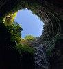
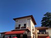
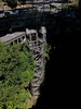
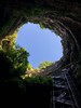
The above images may not be of the site on this page, but were taken nearby. They are loaded from Flickr so please click on them for image credits.
Click here to see more info for this site
Nearby sites
Click here to view sites on an interactive map of the areaKey: Red: member's photo, Blue: 3rd party photo, Yellow: other image, Green: no photo - please go there and take one, Grey: site destroyed
Download sites to:
KML (Google Earth)
GPX (GPS waypoints)
CSV (Garmin/Navman)
CSV (Excel)
To unlock full downloads you need to sign up as a Contributory Member. Otherwise downloads are limited to 50 sites.
Turn off the page maps and other distractions
Nearby sites listing. In the following links * = Image available
649m NE 47° Moussie Dolmen Burial Chamber or Dolmen
1.2km ENE 78° Dolmen du Champ de Monsieur* Burial Chamber or Dolmen
1.4km E 85° Dolmen d'Escurettes* Burial Chamber or Dolmen
2.0km ENE 76° Gouffre de Padirac* Cave or Rock Shelter
2.3km E 89° Dolmen dit des Pendus 1 Burial Chamber or Dolmen
2.4km E 85° Dolmen dit des Pendus 3* Burial Chamber or Dolmen
2.6km ESE 120° Dolmen des Claouzelles Burial Chamber or Dolmen
2.7km E 97° Dolmen des Calcas* Burial Chamber or Dolmen
2.8km ENE 65° Dolmen de Bougoulat* Burial Chamber or Dolmen
3.1km NW 325° Dolmen de Niars Burial Chamber or Dolmen
3.2km WNW 286° Dolmen de Sabadel Burial Chamber or Dolmen
3.2km ENE 77° Croix d'Helene dolmen* Burial Chamber or Dolmen
3.2km NW 307° Dolmen de Barrières 1* Burial Chamber or Dolmen
3.4km WNW 302° Dolmen des Barrières 2* Burial Chamber or Dolmen
3.5km E 90° Dolmen du Pech Plumet 1* Burial Chamber or Dolmen
3.6km WNW 287° Dolmen de la Carture Burial Chamber or Dolmen
3.7km N 7° Dolmen des Igues de Magnagues Burial Chamber or Dolmen
3.7km WNW 296° Dolmen dit la Pierre Levée (Lecusses)* Burial Chamber or Dolmen
3.8km WSW 245° Dolmen du Pech 1* Burial Chamber or Dolmen
3.8km NW 318° Fieux Dolmen* Burial Chamber or Dolmen
3.9km E 89° Dolmen du Pech Plumet 2 Burial Chamber or Dolmen
3.9km NW 311° Gisement de Fieux* Cave or Rock Shelter
4.0km WSW 245° Dolmen du Pech 4 Burial Chamber or Dolmen
4.0km NW 324° Dolmen dit Peyrebru (Miers)* Burial Chamber or Dolmen
4.8km WNW 298° Dolmen du Pech des Auques Burial Chamber or Dolmen
View more nearby sites and additional images


 We would like to know more about this location. Please feel free to add a brief description and any relevant information in your own language.
 Wir möchten mehr über diese Stätte erfahren. Bitte zögern Sie nicht, eine kurze Beschreibung und relevante Informationen in Deutsch hinzuzufügen.
 Nous aimerions en savoir encore un peu sur les lieux. S'il vous plaît n'hesitez pas à ajouter une courte description et tous les renseignements pertinents dans votre propre langue.
 Quisieramos informarnos un poco más de las lugares. No dude en añadir una breve descripción y otros datos relevantes en su propio idioma.