 with our Megalithic Portal iPhone app")

<< Our Photo Pages >> Pierre a Cupules (Arnac) - Standing Stone (Menhir) in France in Limousin:Haute-Vienne (87)
Submitted by TheCaptain on Friday, 27 July 2012 Page Views: 7368
Neolithic and Bronze AgeSite Name: Pierre a Cupules (Arnac) Alternative Name: Arnac Pierre a Cupules, Arnac menhirCountry: France Département: Limousin:Haute-Vienne (87) Type: Standing Stone (Menhir)
Nearest Town: Limoges Nearest Village: Cieux
Latitude: 45.979700N Longitude: 0.974200E
Condition:
| 5 | Perfect |
| 4 | Almost Perfect |
| 3 | Reasonable but with some damage |
| 2 | Ruined but still recognisable as an ancient site |
| 1 | Pretty much destroyed, possibly visible as crop marks |
| 0 | No data. |
| -1 | Completely destroyed |
| 5 | Superb |
| 4 | Good |
| 3 | Ordinary |
| 2 | Not Good |
| 1 | Awful |
| 0 | No data. |
| 5 | Can be driven to, probably with disabled access |
| 4 | Short walk on a footpath |
| 3 | Requiring a bit more of a walk |
| 2 | A long walk |
| 1 | In the middle of nowhere, a nightmare to find |
| 0 | No data. |
| 5 | co-ordinates taken by GPS or official recorded co-ordinates |
| 4 | co-ordinates scaled from a detailed map |
| 3 | co-ordinates scaled from a bad map |
| 2 | co-ordinates of the nearest village |
| 1 | co-ordinates of the nearest town |
| 0 | no data |
Internal Links:
External Links:
I have visited· I would like to visit
johnstone visited on 3rd Sep 2014 - their rating: Cond: 5 Amb: 3 Access: 5
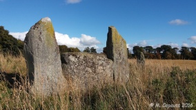
TheCaptain visited on 22nd Jul 2005 - their rating: Cond: 5 Amb: 3 Access: 5 On a green grassy area at the southern edge of the village of Arnac, is found this nice standing stone, standing about 2.5 metres tall. But the noticeable thing about this stone are all the cupules, or cupmarks, engraved into it.
Not immediately obvious in the mid day sunshine, but the first marks to stand out are on the southeast edge, where there appears to be a couple of rows of 35 mm diameter holes running in a line up the edge. Closer inspection shows a very flat southern face - possibly with checkerboard markings on it, and cupules running up the edges from top to bottom. On the northern face, also flattened, the whole stone is covered with these cupules, loads and loads of them. There must be at least a hundred. There does not appear to be anything on the two sides of the stone.
Average ratings for this site from all visit loggers: Condition: 5 Ambience: 3 Access: 5
 (PID:47520)")
Not immediately obvious in the mid day sunshine, but the first marks to stand out are on the southeast edge, where there appears to be a couple of rows of 35 mm diameter holes running in a line up the edge. Closer inspection shows a very flat southern face - possibly with checkerboard markings on it, and cupules running up the edges from top to bottom.
On the northern face, also flattened, the whole stone is covered with these cupules, loads and loads of them. There must be at least a hundred. There does not appear to be anything on the two sides of the stone.
Base Mérimée (Historic Monument)
You may be viewing yesterday's version of this page. To see the most up to date information please register for a free account.
 (PID:91701)")
 (PID:177965)")
 (PID:91700)")
 (PID:91699)")
 (PID:91698)")
 (PID:91697)")
 (PID:20471)")
 (PID:20470)")
Do not use the above information on other web sites or publications without permission of the contributor.
Click here to see more info for this site
Nearby sites
Click here to view sites on an interactive map of the areaKey: Red: member's photo, Blue: 3rd party photo, Yellow: other image, Green: no photo - please go there and take one, Grey: site destroyed
Download sites to:
KML (Google Earth)
GPX (GPS waypoints)
CSV (Garmin/Navman)
CSV (Excel)
To unlock full downloads you need to sign up as a Contributory Member. Otherwise downloads are limited to 50 sites.
Turn off the page maps and other distractions
Nearby sites listing. In the following links * = Image available
1.0km WSW 249° Rouffignac Dolmen* Burial Chamber or Dolmen
1.5km ENE 68° Grotte dite le Rocher des Fées (Cieux)* Cave or Rock Shelter
1.7km NW 308° Ceinturat Menhir* Standing Stone (Menhir)
1.9km NW 308° Ceinturat Menhir 2 Standing Stone (Menhir)
2.0km NNW 347° Pierre à Sacrifice de Cieux* Rock Outcrop
2.8km SE 134° Menhir du Pic* Standing Stone (Menhir)
3.0km SSE 164° Menhir de la Valette Standing Stone (Menhir)
3.6km NE 48° Pierre Branlante de Boscartus* Natural Stone / Erratic / Other Natural Feature
6.0km E 92° Dolmen de la Betoulle* Burial Chamber or Dolmen
6.1km NNE 30° Les Rochers de Puychaud* Rock Outcrop
6.1km NNE 30° Dolmen de Puychaud* Burial Chamber or Dolmen
6.7km N 11° Menhir de Rousseix Standing Stone (Menhir)
7.8km NNE 25° Menhir de Combe Libert Standing Stone (Menhir)
7.8km NNE 26° Menhir de Ruilleres Standing Stone (Menhir)
11.5km NNE 32° Dolmen du Cluzeau 1 Burial Chamber or Dolmen
11.5km NNE 32° Dolmen du Cluzeau 2 Burial Chamber or Dolmen
11.8km NE 40° Belleix Dolmen Burial Chamber or Dolmen
12.1km NE 35° Drouilles Dolmen Burial Chamber or Dolmen
12.2km NE 56° Dolmen du Got Burial Chamber or Dolmen
12.4km WSW 246° Menhirs La Vallade* Standing Stones
12.9km NE 39° La Lue Dolmen* Burial Chamber or Dolmen
13.1km NE 37° Borderie Dolmen* Burial Chamber or Dolmen
13.1km NE 54° Betoulle dolmen 4* Burial Chamber or Dolmen
13.2km NE 54° Betoulle dolmen 3* Burial Chamber or Dolmen
13.2km NE 53° Betoulle dolmen 1* Burial Chamber or Dolmen
View more nearby sites and additional images


 We would like to know more about this location. Please feel free to add a brief description and any relevant information in your own language.
 Wir möchten mehr über diese Stätte erfahren. Bitte zögern Sie nicht, eine kurze Beschreibung und relevante Informationen in Deutsch hinzuzufügen.
 Nous aimerions en savoir encore un peu sur les lieux. S'il vous plaît n'hesitez pas à ajouter une courte description et tous les renseignements pertinents dans votre propre langue.
 Quisieramos informarnos un poco más de las lugares. No dude en añadir una breve descripción y otros datos relevantes en su propio idioma.